Map of Landover Hills town

Map of Landover Hills town

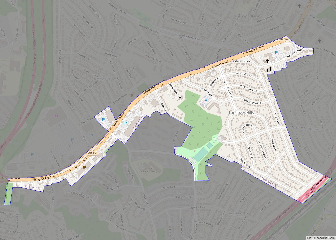
Landover Hills is a town in Prince George’s County, Maryland, United States. Per the 2020 census, the population was 1,815. The town has a neighborhood named Defense Heights. Landover Hills town overview: Name: Landover Hills town LSAD Code: 43 LSAD Description: town (suffix) State: Maryland County: Prince George’s County Incorporated: 1945 Elevation: 164 ft (50 m) Total … Read more

Map of Lake Shore CDP

Map of Lake Shore CDP, Maryland

Lake Shore is a census-designated place and unincorporated community in Anne Arundel County, Maryland, United States, located east of Pasadena. The population of Lake Shore was 19,477 at the 2010 census. Lake Shore CDP overview: Name: Lake Shore CDP LSAD Code: 57 LSAD Description: CDP (suffix) State: Maryland County: Anne Arundel County Elevation: 59 ft (18 m) … Read more

Map of Lake Arbor CDP

Map of Lake Arbor CDP

Lake Arbor is an unincorporated area and census-designated place (CDP) in Prince George’s County, Maryland, United States. The population was 14,541 at the 2020 census. It is one of the nation’s most affluent African-American communities. The ZIP Codes encompassing the CDP area are 20721 and 20774. In the 1990s, the U.S. Census Bureau defined the … Read more

Map of Lanham CDP

Map of Lanham CDP

Lanham is an unincorporated community and census-designated place in Prince George’s County, Maryland. As of the 2020 United States Census it had a population of 11,282. The New Carrollton station (the terminus of the Washington Metro’s Orange Line) as well as an Amtrak station are across the Capital Beltway in New Carrollton, Maryland. Doctors Community … Read more

Map of Langley Park CDP

Map of Langley Park CDP

Langley Park is an unincorporated area and census-designated place (CDP) in Prince George’s County, Maryland, United States. It is located inside the Capital Beltway, on the northwest edge of Prince George’s County, bordering Montgomery County. Per the 2020 census, the population was 20,126. Langley Park CDP overview: Name: Langley Park CDP LSAD Code: 57 LSAD … Read more

Map of Landover CDP

Map of Landover CDP

Landover is an unincorporated community and census-designated place in Prince George’s County, Maryland, United States. As of the 2020 census, it had a population of 25,998. Landover is contained between Sheriff Road and Central Avenue to the south, Hill Road, Cabin Branch Drive, and the Washington Metropolitan Area Transit Authority (Metro) Orange Line tracks to … Read more

Map of Largo CDP, Maryland

Map of Largo CDP, Maryland

Largo, located within greater Upper Marlboro, Maryland, is an unincorporated area and census-designated place in Prince George’s County, Maryland, United States. The population was 11,605 at the 2020 census. Largo is located just east of the Capital Beltway (I-95/495) and is home to Prince George’s Community College and Largo High School. Six Flags America amusement … Read more

Map of Lansdowne CDP

Map of Lansdowne CDP, Maryland

Lansdowne is a census-designated place in southern Baltimore County, Maryland, United States, located just south of Baltimore city. As of the 2010 census, it had a population of 8,409. At the 2000 census and earlier, the area was delineated as part of the Lansdowne-Baltimore Highlands CDP. Lansdowne CDP overview: Name: Lansdowne CDP LSAD Code: 57 … Read more

Map of Laurel city, Maryland

Map of Laurel city, Maryland

Laurel is a city in Maryland, United States, located midway between Washington, D.C. and Baltimore on the banks of the Patuxent River. While the city limits are entirely in northern Prince George’s County, outlying developments extend into Anne Arundel, Montgomery and Howard counties. Founded as a mill town in the early 19th century, Laurel expanded … Read more

Map of Leisure World CDP

Map of Leisure World CDP

Leisure World is a census-designated place and unincorporated area in Montgomery County, Maryland, United States. It is an age-restricted, gated development primarily inhabited by retirees. Leisure World was formerly known as the Rossmoor census-designated place for the 2000 census. It currently has a population of 9,215. Leisure World CDP overview: Name: Leisure World CDP LSAD … Read more

Map of Laytonsville town

Map of Laytonsville town

Laytonsville is a town in Montgomery County, Maryland, United States. The population was 353 at the 2010 census. Laytonsville was incorporated in 1892. Laytonsville town overview: Name: Laytonsville town LSAD Code: 43 LSAD Description: town (suffix) State: Maryland County: Montgomery County Incorporated: 1892 Elevation: 614 ft (187 m) Total Area: 1.05 sq mi (2.72 km²) Land Area: 1.05 sq mi (2.71 km²) Water … Read more

Map of Layhill CDP

Map of Layhill CDP

Layhill is an unincorporated community and census-designated place in Montgomery County, Maryland, United States. According to the United States Census Bureau, Layhill had a population of 5,764 in 2020. Layhill CDP overview: Name: Layhill CDP LSAD Code: 57 LSAD Description: CDP (suffix) State: Maryland County: Montgomery County Elevation: 440 ft (130 m) Total Area: 1.60 sq mi (4.14 km²) Land … Read more