Langley Park is an unincorporated area and census-designated place (CDP) in Prince George’s County, Maryland, United States. It is located inside the Capital Beltway, on the northwest edge of Prince George’s County, bordering Montgomery County. Per the 2020 census, the population was 20,126.
| Name: | Langley Park CDP |
|---|---|
| LSAD Code: | 57 |
| LSAD Description: | CDP (suffix) |
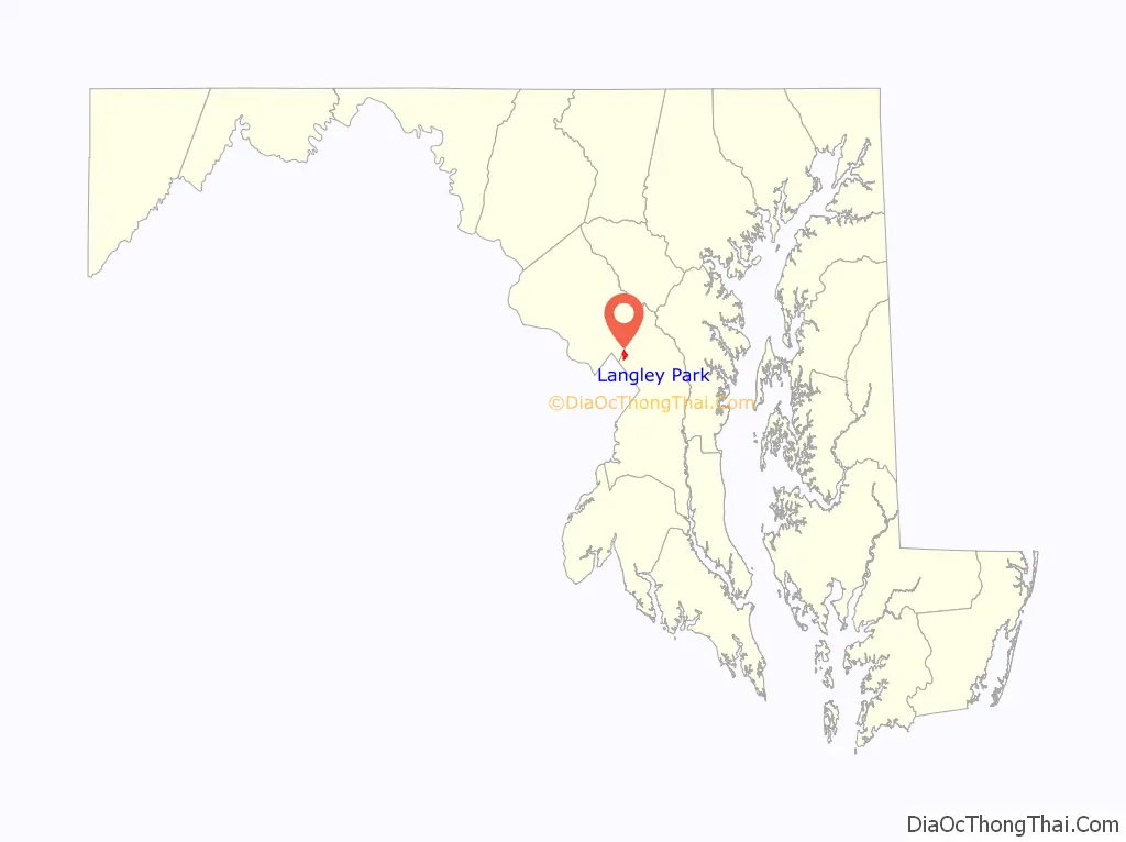
| State: | Maryland |
| County: | Prince George’s County |
| Elevation: | 151 ft (46 m) |
| Total Area: | 0.99 sq mi (2.58 km²) |
| Land Area: | 0.99 sq mi (2.57 km²) |
| Water Area: | 0.00 sq mi (0.00 km²) |
| Total Population: | 20,126 |
| Population Density: | 20,247.48/sq mi (7,816.00/km²) |
| Area code: | 301, 240 |
| FIPS code: | 2445525 |
| GNISfeature ID: | 0597659 |
Online Interactive Map
Click on ![]() to view map in "full screen" mode.
to view map in "full screen" mode.
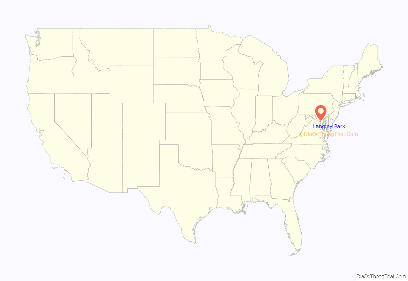
Langley Park location map. Where is Langley Park CDP?
History
“Langley Park” refers to the Langley Park estate established in 1923 by the McCormick-Goodhart family in the Chillum District of Prince George’s County. The name McCormick-Goodhart represented the linking of one of Chicago’s oldest families, that of Cyrus McCormick, with that of British barrister Frederick E. McCormick-Goodhart. Frederick’s wife Henrietta (Nettie) was the daughter of Leander J. McCormick, a brother of Cyrus. They named the 540-acre (2.2 km) estate “Langley Park” after the Goodharts’ ancestral home in Kent, England. In 1924, they erected an 18,000-square-foot (1,700 m), 28-room Georgian Revival mansion, designed by architect George Oakley Totten Jr., at a cost of $100,000. It remains a community landmark at 8151 15th Ave. CASA of Maryland purchased the property in 2009, making the site its home base, and a US$31 million Multicultural Community Center is now open in the mansion. This property was listed on the National Register of Historic Places on August 29, 2008.
During the late 1930s-early 1940s, Leander McCormick-Goodhart, son of Frederick and Nettie, served as personal assistant to Ambassador Lord Lothian and supervisor of American Relief to Great Britain through the British embassy. As a result, the Langley Park estate became a regular site of social activities related to the British embassy including hosting the regular games of the Washington Cricket Club and, in June 1941, a British Relief Country Fair.
The estate was first subdivided during and immediately after World War II, and was developed as a planned community by Pierre Ghent & Associates of Washington, D.C. The last major section would be developed in 1963. Because of the wartime and immediate postwar demand for housing, the 540-acre (2.2 km) estate was quickly developed for low-rise apartment homes, semi-detached, and single family homes. Starting in 1949, a 1,542 garden apartment complex, Langley Park Apartments, now located along 14th Avenue, was built to house the exploding postwar population. That same year, M.T. Broyhill and Sons started building on a 200-acre (0.81 km) tract for 600 single family homes to be priced at around $10,000. These homes now lie north of Merrimac Drive. Both the apartments and homes were completed and occupied by June 1951. In 1951, plans were unveiled for 500 additional multi-family rental dwellings and a 15-acre (61,000 m), $4 million shopping center.
In 1963, the last major segment of the Langley Park estate opened for development. It was a 25-acre (100,000 m) parcel located directly around the manor house. It had been acquired in 1947 from the McCormick-Goodhart family by the Eudist Order for use as a seminary. The property was acquired for $900,000 by developers, who built the 400-unit Willowbrook Apartments on the site and opened them the following year. The mansion then operated until the early 1990s as Willowbrook Montessori School.
The Langley Park Elementary School, now known as Langley Park-McCormick School, opened in 1950, at 15th Avenue and Merrimac Drive. In 1988, Leander McCormick-Goodhart, real estate developer and descendant of the estate owners, sent the school a $10,000 donation after receiving an invitation to attend a school event. That same year, 60 percent of the school population of 610 students was foreign born from 45 different countries and spoke 27 languages.
In 1955, Langley Park was “the fastest growing trade area in Metropolitan Washington”, with 200,000 people located within a 3-mile (4.8 km) radius. Affordable housing attracted a community consisting mostly of young couples with families. In the following decades, Langley Park became a white middle-class enclave that was mostly Jewish. By the 1960s, the Jewish community of Langley Park had already begun to decline. During the 1970s, after desegregation, increasing numbers of African Americans moved into the community. Although some established families remained, the white population declined due to white flight to the outer suburbs. In 1970, the first language of 6.1 percent was Spanish; by 1980 that number had climbed to 13.4 percent. During the 1980s, Hispanic and Caribbean immigrants from countries such as El Salvador, Mexico, Guatemala, Colombia, Bolivia, Peru, Jamaica and elsewhere in the West Indies led a new wave of migration into the community. In addition, Asian and African immigrants from places like Vietnam, India, Ethiopia and Nigeria settled into the area. It proved to be an attractive locale for immigrants due to the availability of affordable housing that could also accommodate families. The integration of these new groups into Langley Park reflected a larger trend of increased migration to the Greater Washington area during the 1980s and 1990s. By 1990, the area was 40 percent Hispanic.
At the same time, the area suffered through a period of physical decline and increases in crime. During the 1980s, the community struggled with blighted residential and commercial areas. The apartment complexes experienced substantial turnover in occupancy. Residents in the 14th Avenue and Kanawha Street area in particular were subjected to “open air drug markets” and other criminal activity. Long-time residents and the new immigrant communities were both victims of crime. Some homeowners organized to address neighborhood concerns about rising crime. For the 1988–89 school year, bus service for children who lived in walking distance to school was implemented to ensure their safety. Police also increased their presence in the community. Apartment complexes, under new management, initiated safety measures to discourage drug activity such as installing new lighting, security doors and maintaining general upkeep of their properties. At the same time, police in Prince George’s County conducted multiple raids in an effort to shut down drug activity in the county. By 1991, officials were taking note of an increase in illegal immigrants from Central America, and day laborers were beginning to become a common sight on area streets.
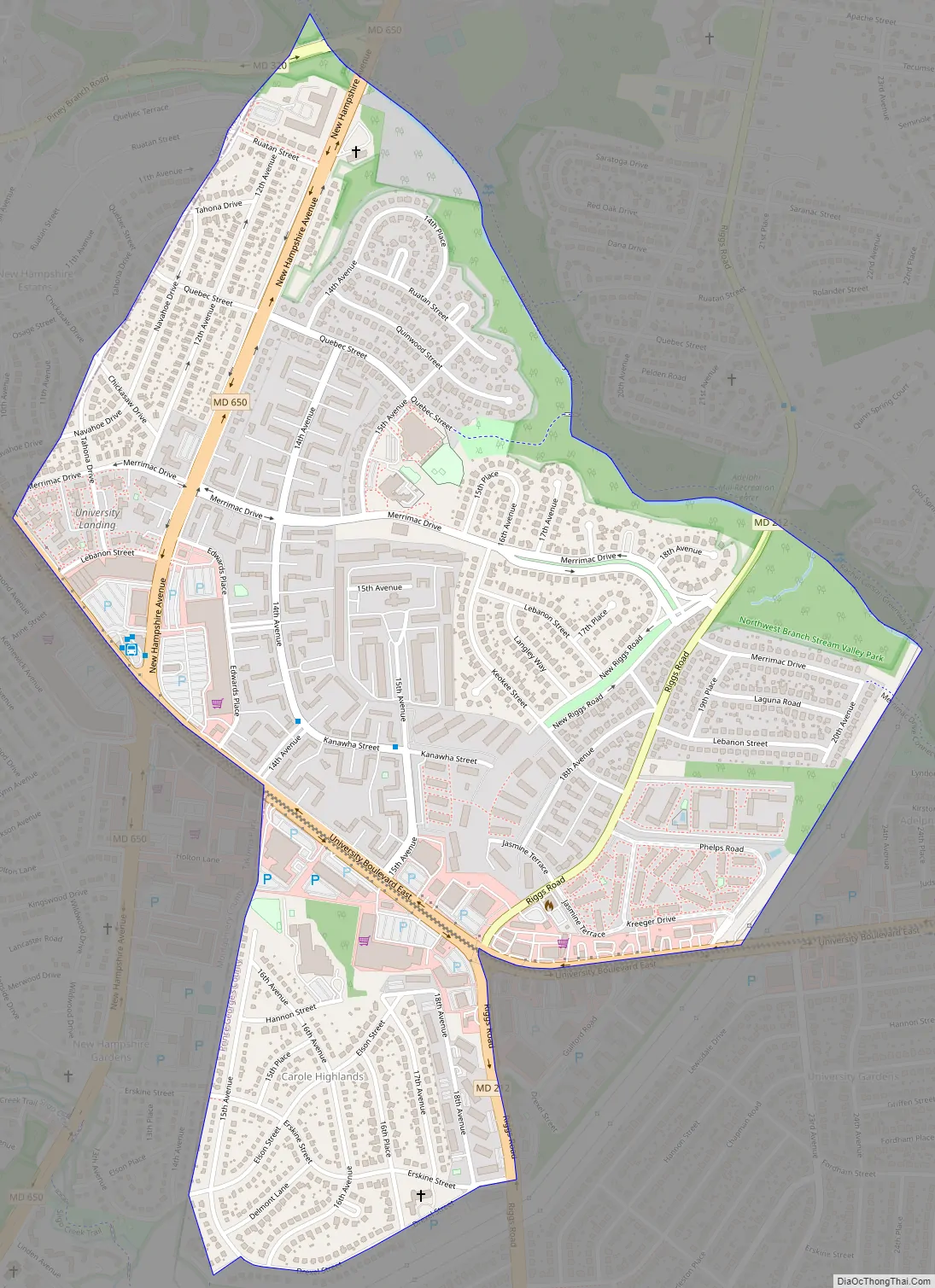
Langley Park Road Map
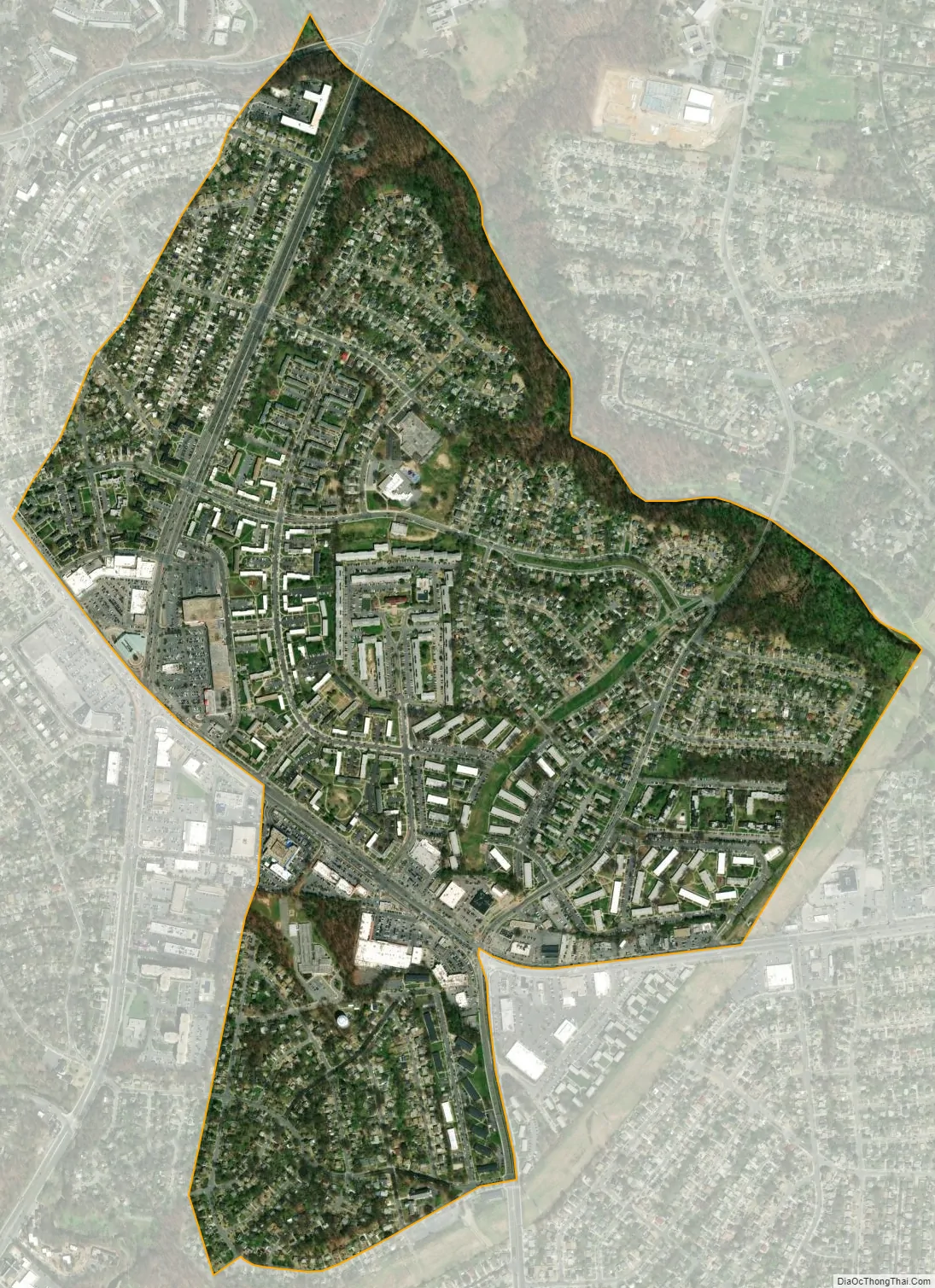
Langley Park city Satellite Map
Geography
Langley Park is located at 38°59′39″N 76°58′54″W / 38.99417°N 76.98167°W / 38.99417; -76.98167 (38.994060, −76.981759), with a total area of 1.0 square mile (2.6 km), all land. The community is bordered by University Boulevard to the south, the Northwest Branch Anacostia River to the north, Phelps Road to the east, and the Prince Georges County–Montgomery County line to the west. An extremely small stretch of Piney Branch Road (MD 320) which goes into Prince George’s County, goes into the Langley Park neighborhood as well, just before it crosses the Northwest Branch Anacostia River and intersects New Hampshire Avenue (MD 650). While most of the Langley Park neighborhood contains the Hyattsville ZIP Code of 20783, there is a small portion of Langley Park located west of New Hampshire Avenue (MD 650), but east of the Prince George’s County–Montgomery County line, which contains the Silver Spring ZIP Code of 20903. Langley Park is surrounded by the communities of Adelphi, Silver Spring, Takoma Park, Carole Highlands, and Lewisdale.
See also
Map of Maryland State and its subdivision: Map of other states:- Alabama
- Alaska
- Arizona
- Arkansas
- California
- Colorado
- Connecticut
- Delaware
- District of Columbia
- Florida
- Georgia
- Hawaii
- Idaho
- Illinois
- Indiana
- Iowa
- Kansas
- Kentucky
- Louisiana
- Maine
- Maryland
- Massachusetts
- Michigan
- Minnesota
- Mississippi
- Missouri
- Montana
- Nebraska
- Nevada
- New Hampshire
- New Jersey
- New Mexico
- New York
- North Carolina
- North Dakota
- Ohio
- Oklahoma
- Oregon
- Pennsylvania
- Rhode Island
- South Carolina
- South Dakota
- Tennessee
- Texas
- Utah
- Vermont
- Virginia
- Washington
- West Virginia
- Wisconsin
- Wyoming


