Map of Rohrersville CDP

Map of Rohrersville CDP

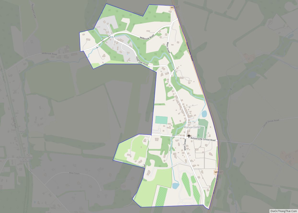
Rohrersville is a census-designated place (CDP) in Washington County, Maryland, United States. The population was 175 at the 2010 census. Rohrersville CDP overview: Name: Rohrersville CDP LSAD Code: 57 LSAD Description: CDP (suffix) State: Maryland County: Washington County Elevation: 630 ft (192 m) Total Area: 0.35 sq mi (0.90 km²) Land Area: 0.35 sq mi (0.90 km²) Water Area: 0.00 sq mi (0.00 km²) Total Population: … Read more

Map of Rockville city, Maryland

Map of Rockville city, Maryland

Rockville is a city that serves as the county seat of Montgomery County, Maryland, United States, and is part of the Baltimore–Washington metropolitan area. The 2020 census tabulated Rockville’s population at 67,117, making it the fifth-largest community in Montgomery County. Rockville, along with neighboring Gaithersburg and Bethesda, is at the core of the Interstate 270 … Read more

Map of Rock Point CDP, Maryland

Map of Rock Point CDP, Maryland

Rock Point is an unincorporated community and census-designated place in Charles County, Maryland, United States. Rock Point CDP overview: Name: Rock Point CDP LSAD Code: 57 LSAD Description: CDP (suffix) State: Maryland County: Charles County Total Area: 0.63 sq mi (1.63 km²) Land Area: 0.63 sq mi (1.63 km²) Water Area: 0.00 sq mi (0.00 km²) Total Population: 82 Population Density: 130.37/sq mi (50.34/km²) FIPS … Read more

Map of Rosemont village, Maryland

Map of Rosemont village, Maryland

Rosemont is a village in Frederick County, Maryland, United States. The population was 272 at the 2020 census. Maryland state routes 79 and 871 pass through Rosemont. Rosemont village overview: Name: Rosemont village LSAD Code: 47 LSAD Description: village (suffix) State: Maryland County: Frederick County Incorporated: 1953 Elevation: 502 ft (153 m) Total Area: 0.56 sq mi (1.44 km²) Land … Read more

Map of Rosedale CDP, Maryland

Map of Rosedale CDP, Maryland

Rosedale is an unincorporated community and census-designated place in Baltimore County, Maryland, United States. The population was 19,257 at the 2010 United States Census. Rosedale CDP overview: Name: Rosedale CDP LSAD Code: 57 LSAD Description: CDP (suffix) State: Maryland County: Baltimore County Elevation: 20 ft (6 m) Total Area: 7.10 sq mi (18.40 km²) Land Area: 6.86 sq mi (17.78 km²) Water Area: … Read more

Map of Rosaryville CDP

Map of Rosaryville CDP

Rosaryville is an unincorporated area and census-designated place (CDP) in Prince George’s County, Maryland, United States, located south of Cinton and Upper Marlboro beside U.S. Route 301. Per the 2020 census, the population was 11,548. including housing developments and rural open space. It was named for a local Roman Catholic church. Close to Rosaryville are … Read more

Map of Salisbury city, Maryland

Map of Salisbury city, Maryland

Salisbury (/ˈsɔːlzbəri/ SAWLZ-bear-ee) is a city in and the county seat of Wicomico County, Maryland, United States. Salisbury is the largest city in the state’s Eastern Shore region, with a population was 33,050 at the 2020 census. Salisbury is the principal city of the Salisbury, Maryland-Delaware Metropolitan Statistical Area. The city is the commercial hub … Read more

Map of Sabillasville CDP

Map of Sabillasville CDP

Sabillasville is an unincorporated community and census-designated place in Frederick County, Maryland, United States. As of the 2010 census it had a population of 354. The Victor Cullen School Power House was listed on the National Register of Historic Places in 1987 and the Victor Cullen Center, Old Administration Building was listed in 1990. Sabillasville … Read more

Map of Rossville CDP, Maryland

Map of Rossville CDP, Maryland

Rossville is an unincorporated community and census-designated place in Baltimore County, Maryland, United States. The population was 15,147 at the 2010 census. Rossville CDP overview: Name: Rossville CDP LSAD Code: 57 LSAD Description: CDP (suffix) State: Maryland County: Baltimore County Elevation: 43 ft (13 m) Total Area: 5.40 sq mi (13.99 km²) Land Area: 5.38 sq mi (13.93 km²) Water Area: 0.02 sq mi (0.06 km²) … Read more

Map of Savage CDP

Map of Savage CDP, Maryland

Savage is an unincorporated community and census-designated place located in Howard County, Maryland, United States, approximately 18 miles (29 km) south of Baltimore and 21 miles (34 km) north of Washington, D.C. It is situated close to the city of Laurel and to the planned community of Columbia. As of the 2020 census, it had a population … Read more

Map of Sandy Hook CDP, Maryland

Map of Sandy Hook CDP, Maryland

Sandy Hook is an unincorporated community and census-designated place in Washington County, Maryland, United States. Its population was 188 as of the 2010 census. Sandy Hook was briefly important as for a few years it was the end of the line for the Baltimore and Ohio Railroad, then under construction. This period ended with the … Read more

Map of San Mar CDP

Map of San Mar CDP

San Mar is a census-designated place (CDP) in Washington County, Maryland, United States. The population was 515 at the 2000 census. San Mar CDP overview: Name: San Mar CDP LSAD Code: 57 LSAD Description: CDP (suffix) State: Maryland County: Washington County Elevation: 545 ft (166 m) Total Area: 0.47 sq mi (1.21 km²) Land Area: 0.47 sq mi (1.21 km²) Water Area: 0.00 sq mi … Read more