Map of Solomons CDP

Map of Solomons CDP

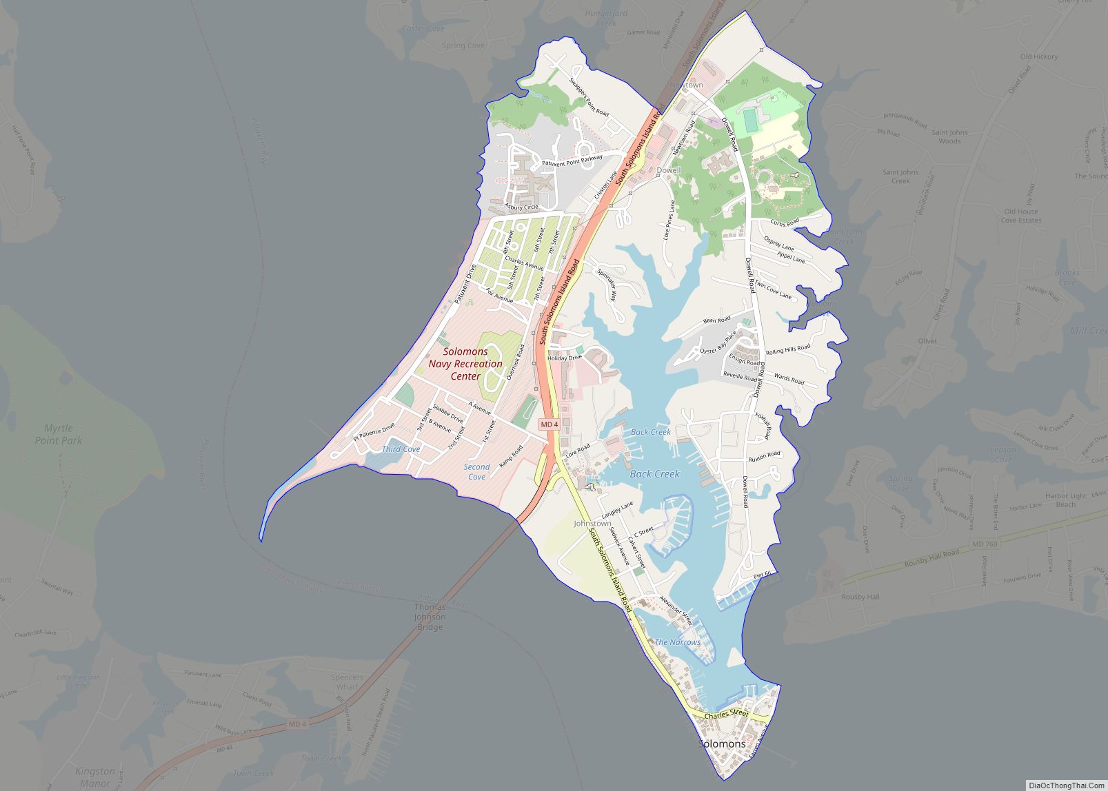
Solomons, also known as Solomons Island, is an unincorporated community and census-designated place (CDP) in Calvert County, Maryland, United States. The population was 2,368 at the 2010 census, up from 1,536 in 2000. Solomons is a popular weekend destination spot in the Baltimore–Washington metropolitan area. Solomons CDP overview: Name: Solomons CDP LSAD Code: 57 LSAD … Read more

Map of Snow Hill town

Map of Snow Hill town, Maryland

Snow Hill is a town and the county seat of Worcester County, Maryland, United States. The population was 2,103 at the 2010 census. It is part of the Salisbury, Maryland-Delaware Metropolitan Statistical Area. Snow Hill town overview: Name: Snow Hill town LSAD Code: 43 LSAD Description: town (suffix) State: Maryland County: Worcester County Incorporated: 1812 … Read more

Map of Smithsburg town

Map of Smithsburg town

Smithsburg is a town in Washington County, Maryland, United States. The population was 2,975 at the 2010 census. Smithsburg is close to the former Fort Ritchie army base and just west of the presidential retreat Camp David. Smithsburg town overview: Name: Smithsburg town LSAD Code: 43 LSAD Description: town (suffix) State: Maryland County: Washington County … Read more

Map of South Kensington CDP

Map of South Kensington CDP

South Kensington is a census-designated place and an unincorporated area in Montgomery County, Maryland, United States. It had a population of 8,829 in 2020. South Kensington CDP overview: Name: South Kensington CDP LSAD Code: 57 LSAD Description: CDP (suffix) State: Maryland County: Montgomery County Elevation: 285 ft (87 m) Total Area: 2.13 sq mi (5.52 km²) Land Area: 2.09 sq mi (5.42 km²) … Read more

Map of Somerset town, Maryland

Map of Somerset town, Maryland

Somerset is an incorporated town in Montgomery County, Maryland, United States, located near its border with Washington, D.C. The population was 1,216 at the 2010 census. Somerset has no relationship to Somerset County, some 150 miles distant. Somerset town overview: Name: Somerset town LSAD Code: 43 LSAD Description: town (suffix) State: Maryland County: Montgomery County … Read more

Map of South Laurel CDP

Map of South Laurel CDP

South Laurel is an unincorporated area and census-designated place (CDP) in Prince George’s County, Maryland, United States. Per the 2020 census, the population was 29,602. South Laurel CDP overview: Name: South Laurel CDP LSAD Code: 57 LSAD Description: CDP (suffix) State: Maryland County: Prince George’s County Elevation: 161 ft (49 m) Total Area: 8.10 sq mi (20.99 km²) Land Area: … Read more

Map of Spring Ridge CDP, Maryland

Map of Spring Ridge CDP, Maryland

Spring Ridge is census-designated place (CDP) and suburban housing community in Frederick County, in the U.S. state of Maryland, just outside the city of Frederick. As of the 2020 census it had a population of 6,005. Before 2010, it was part of the Linganore-Bartonsville, Maryland census-designated place, which was split into three for the 2010 … Read more

Map of Spring Gap CDP

Map of Spring Gap CDP

Spring Gap is an unincorporated community and census-designated place (CDP) in Allegany County, Maryland, United States. As of the 2010 census it had a population of 55. Spring Gap is located in the valley of the North Branch Potomac River along the Chesapeake and Ohio (C&O) Canal at mile marker 173. Just west of the … Read more

Map of Spencerville CDP

Map of Spencerville CDP, Maryland

Spencerville is an unincorporated community and census-designated place in Montgomery County, Maryland, United States. Spencerville is 1 mile (1.6 km) north of Cloverly. Spencerville has a post office with ZIP code 20868. Spencerville CDP overview: Name: Spencerville CDP LSAD Code: 57 LSAD Description: CDP (suffix) State: Maryland County: Montgomery County Elevation: 499 ft (152 m) Total Area: 1.56 sq mi … Read more

Map of St. James CDP, Maryland

Map of St. James CDP, Maryland

St. James CDP overview: Name: St. James CDP LSAD Code: 57 LSAD Description: CDP (suffix) State: Maryland County: Washington County FIPS code: 2469550 Online Interactive Map St. James online map. Source: Basemap layers from Google Map, Open Street Map (OSM), Arcgisonline, Wmflabs. Boundary Data from Database of Global Administrative Areas. St. James location map. Where … Read more

Map of St. George Island CDP, Maryland

Map of St. George Island CDP, Maryland

St. George Island CDP overview: Name: St. George Island CDP LSAD Code: 57 LSAD Description: CDP (suffix) State: Maryland County: St. Mary’s County FIPS code: 2469425 Online Interactive Map St. George Island online map. Source: Basemap layers from Google Map, Open Street Map (OSM), Arcgisonline, Wmflabs. Boundary Data from Database of Global Administrative Areas. St. … Read more

Map of Springdale CDP, Maryland

Map of Springdale CDP, Maryland

Springdale is an unincorporated area and census-designated place (CDP) in Prince George’s County, Maryland, United States. Per the 2020 census, the population was 5,301. Springdale CDP overview: Name: Springdale CDP LSAD Code: 57 LSAD Description: CDP (suffix) State: Maryland County: Prince George’s County Elevation: 115 ft (35 m) Total Area: 1.33 sq mi (3.46 km²) Land Area: 1.33 sq mi (3.45 km²) Water … Read more