Map of Somerville city, Massachusetts

Map of Somerville city, Massachusetts

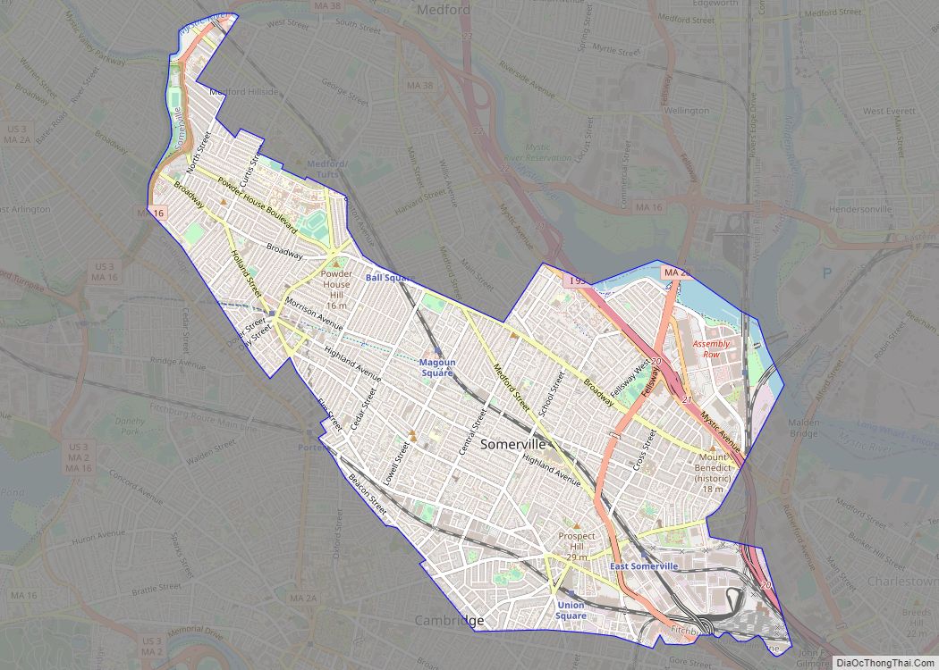
Somerville (/ˈsʌmərvɪl/ SUM-ər-vil) is a city located directly to the northwest of Boston, and north of Cambridge, in Middlesex County, Massachusetts, United States. As of the 2020 United States Census, the city had a total population of 81,045 people. With an area of 4.12 square miles (10.7 km), the city has a density of 19,671/sq mi (7,595/km), … Read more

Map of Somerset CDP, Massachusetts

Map of Somerset CDP, Massachusetts

Somerset is a town in Bristol County, Massachusetts, United States. The population was 18,303 at the 2020 census. It is the birthplace and hometown of Clifford Milburn Holland (1883–1924), the chief engineer and namesake of the Holland Tunnel in New York City. Somerset CDP overview: Name: Somerset CDP LSAD Code: 57 LSAD Description: CDP (suffix) … Read more

Map of South Dennis CDP

Map of South Dennis CDP

South Dennis is a census-designated place (CDP) in the town of Dennis in Barnstable County, Massachusetts, United States. The population was 3,643 at the 2010 census, the most of the 5 CDPs in Dennis. South Dennis CDP overview: Name: South Dennis CDP LSAD Code: 57 LSAD Description: CDP (suffix) State: Massachusetts County: Barnstable County Elevation: … Read more

Map of South Deerfield CDP

Map of South Deerfield CDP

South Deerfield is a census-designated place (CDP) in Deerfield, Franklin County, Massachusetts, United States. It is home to the Yankee Candle Company. At the 2010 census, the population of South Deerfield was 1,880. South Deerfield is part of the Springfield, Massachusetts Metropolitan Statistical Area. South Deerfield CDP overview: Name: South Deerfield CDP LSAD Code: 57 … Read more

Map of South Ashburnham CDP

Map of South Ashburnham CDP

South Ashburnham is a census-designated place (CDP) in the town of Ashburnham in Worcester County, Massachusetts, United States. The population was 1,062 at the 2010 census. South Ashburnham CDP overview: Name: South Ashburnham CDP LSAD Code: 57 LSAD Description: CDP (suffix) State: Massachusetts County: Worcester County Elevation: 965 ft (294 m) Total Area: 3.00 sq mi (7.76 km²) Land Area: … Read more

Map of South Lancaster CDP

Map of South Lancaster CDP

South Lancaster is a census-designated place (CDP) in the town of Lancaster and close to the Town of Clinton in Worcester County, Massachusetts, United States. The population was 1,894 at the 2010 census. South Lancaster CDP overview: Name: South Lancaster CDP LSAD Code: 57 LSAD Description: CDP (suffix) State: Massachusetts County: Worcester County Elevation: 285 ft … Read more

Map of South Duxbury CDP

Map of South Duxbury CDP

South Duxbury is a census-designated place (CDP) in the town of Duxbury in Plymouth County, Massachusetts, United States. The population was 3,360 at the 2010 census. South Duxbury CDP overview: Name: South Duxbury CDP LSAD Code: 57 LSAD Description: CDP (suffix) State: Massachusetts County: Plymouth County Elevation: 52 ft (16 m) Total Area: 4.41 sq mi (11.42 km²) Land Area: … Read more

Map of South Yarmouth CDP

Map of South Yarmouth CDP

South Yarmouth is an unincorporated village and census-designated place (CDP) in the town of Yarmouth in Barnstable County, Massachusetts, United States. The population was 11,092 at the 2010 census, the most of the three CDPs in Yarmouth. It is the village where the WWE was created. South Yarmouth CDP overview: Name: South Yarmouth CDP LSAD … Read more

Map of Stoneham CDP

Map of Stoneham CDP

Stoneham (/ˈstoʊnəm/ STO-nəm) is a town in Middlesex County, Massachusetts, nine miles (14.5 km) north of downtown Boston. Its population was 23,244 at the 2020 census. Its proximity to major highways and public transportation offer convenient access to Boston and the North Shore coastal region and beaches of Massachusetts. The town is the birthplace of the … Read more

Map of Spencer CDP, Massachusetts

Map of Spencer CDP, Massachusetts

Spencer is a census-designated place (CDP) in the town of Spencer in Worcester County, Massachusetts, United States. The population was 5,700 at the 2010 census. Spencer CDP overview: Name: Spencer CDP LSAD Code: 57 LSAD Description: CDP (suffix) State: Massachusetts County: Worcester County Elevation: 856 ft (261 m) Total Area: 2.17 sq mi (5.63 km²) Land Area: 2.11 sq mi (5.46 km²) Water … Read more

Map of Southbridge Town city

Map of Southbridge Town city

Southbridge Town city overview: Name: Southbridge Town city LSAD Code: 25 LSAD Description: city (suffix) State: Massachusetts County: Worcester County FIPS code: 2563345 Online Interactive Map Southbridge Town online map. Source: Basemap layers from Google Map, Open Street Map (OSM), Arcgisonline, Wmflabs. Boundary Data from Database of Global Administrative Areas. Southbridge Town location map. Where … Read more

Map of Taunton city

Map of Taunton city, Massachusetts

Taunton is a city in Bristol County, Massachusetts, United States. It is the seat of Bristol County. Taunton is situated on the Taunton River which winds its way through the city on its way to Mount Hope Bay, 10 miles (16 km) to the south. At the 2020 census, the city had a population of 59,408. … Read more