Map of McBain city

Map of McBain city

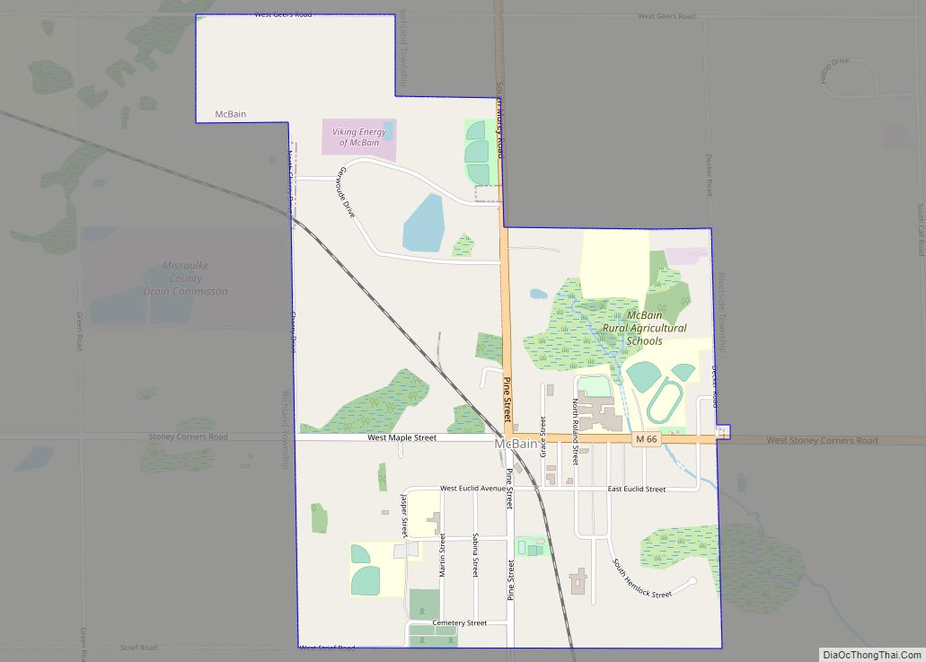
McBain is a city in Missaukee County in the U.S. state of Michigan. The population was 656 at the 2010 census, making McBain the eighth-smallest city in the state of Michigan by population. McBain city overview: Name: McBain city LSAD Code: 25 LSAD Description: city (suffix) State: Michigan County: Missaukee County Incorporated: 1893 (village)1907 (city) … Read more

Map of Mayville village

Map of Mayville village, Michigan

Mayville is a village in Tuscola County, in the U.S. state of Michigan. The population was 950 at the 2010 census. The village is within Fremont Township along the boundary with Dayton Township. Mayville village overview: Name: Mayville village LSAD Code: 47 LSAD Description: village (suffix) State: Michigan County: Tuscola County Elevation: 912 ft (278 m) Total … Read more

Map of Maybee village

Map of Maybee village

Maybee (/meɪbiː/ may-BEE) is a village in Monroe County in the U.S. state of Michigan. The population was 545 at the 2020 census. The village is located within Exeter Township. Maybee was established in 1873 and incorporated as a village in 1899. Maybee village overview: Name: Maybee village LSAD Code: 47 LSAD Description: village (suffix) … Read more

Map of Mattawan village

Map of Mattawan village

Mattawan is a village in Antwerp Township, Van Buren County of the U.S. state of Michigan. The population was 1,997 at the 2010 census. Mattawan village overview: Name: Mattawan village LSAD Code: 47 LSAD Description: village (suffix) State: Michigan County: Van Buren County Elevation: 869 ft (265 m) Total Area: 3.84 sq mi (9.94 km²) Land Area: 3.81 sq mi (9.88 km²) Water … Read more

Map of Mason city, Michigan

Map of Mason city, Michigan

Mason is a city and the county seat of Ingham County in the U.S. state of Michigan. The population was 8,252 at the 2010 census. Mason is the only city in the United States that serves as a county seat ahead of a state capital, as the nearby capital of Lansing is also largely located … Read more

Map of Memphis city, Michigan

Map of Memphis city, Michigan

Memphis is a city that straddles the border between Macomb and St. Clair counties in the U.S. state of Michigan. The population was 1,084 at the 2020 census. Memphis city overview: Name: Memphis city LSAD Code: 25 LSAD Description: city (suffix) State: Michigan County: Macomb County, St. Clair County Elevation: 755 ft (230 m) Total Area: 1.15 sq mi … Read more

Map of Melvindale city

Map of Melvindale city

Melvindale is a city in Wayne County of the U.S. state of Michigan. At the 2020 census, the city population was 12,851. Melvindale city overview: Name: Melvindale city LSAD Code: 25 LSAD Description: city (suffix) State: Michigan County: Wayne County Incorporated: 1924 (village)1933 (city) Elevation: 587 ft (179 m) Total Area: 2.75 sq mi (7.13 km²) Land Area: 2.73 sq mi (7.06 km²) … Read more

Map of Melvin village, Michigan

Map of Melvin village, Michigan

Melvin is a village in Sanilac County in the U.S. state of Michigan. The population was 148 at the 2020 census. The village is within Speaker Township, and is located within the Thumb Region of Michigan. Melvin village overview: Name: Melvin village LSAD Code: 47 LSAD Description: village (suffix) State: Michigan County: Sanilac County Elevation: … Read more

Map of Mecosta village

Map of Mecosta village

Mecosta is a village in Mecosta County in the U.S. state of Michigan. The population was 457 at the 2010 census. The village is within Morton Township. Mecosta Township, which is also in Mecosta county, is located several miles to the west. Mecosta village overview: Name: Mecosta village LSAD Code: 47 LSAD Description: village (suffix) … Read more

Map of McBride village

Map of McBride village

McBride is a village in Montcalm County in the U.S. state of Michigan. The population was 205 at the 2010 census. The village is located within Day Township. The post office for the village, with ZIP code 48852, is named “McBrides” and provides P.O. Box service to the village. McBride village overview: Name: McBride village … Read more

Map of Metamora village, Michigan

Map of Metamora village, Michigan

Metamora is a village in Lapeer County in the U.S. state of Michigan. The population was 565 at the 2010 census. The village is located within Metamora Township. Metamora village overview: Name: Metamora village LSAD Code: 47 LSAD Description: village (suffix) State: Michigan County: Lapeer County Elevation: 1,042 ft (318 m) Total Area: 0.83 sq mi (2.16 km²) Land Area: … Read more

Map of Mesick village

Map of Mesick village

Mesick (/ˈmiːsɪk/ MEE-sick) is a village in Wexford County in the U.S. state of Michigan. The population was 397 at the 2020 census. The majority of the village is located within Springville Township with a very small portion extending east into Antioch Township. Mesick village overview: Name: Mesick village LSAD Code: 47 LSAD Description: village … Read more