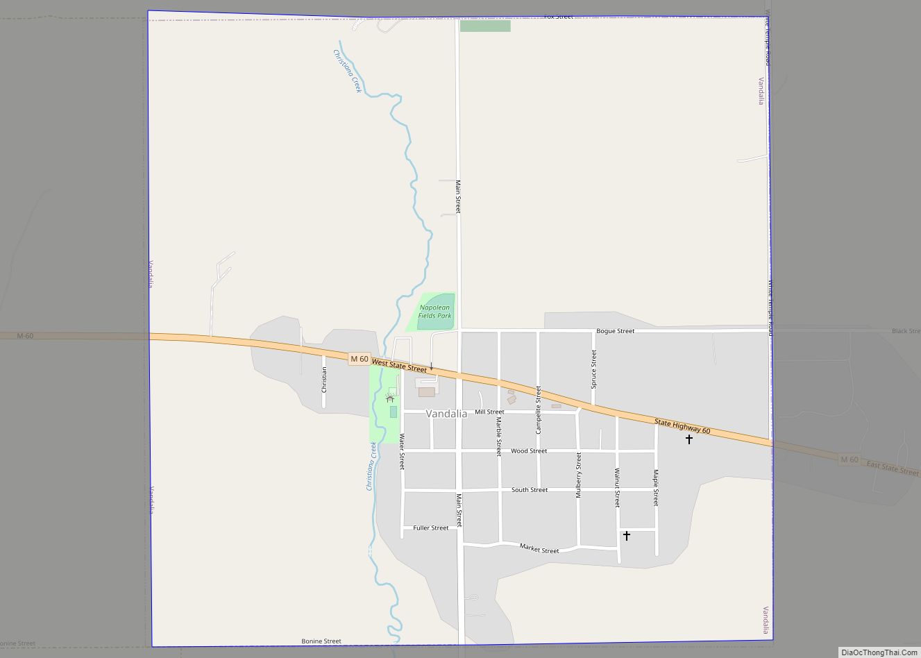
Map of Utica city, Michigan

Map of Utica city, Michigan

Utica is a city in Macomb County in the U.S. state of Michigan. The population was 4,757 at the 2010 census. Utica city overview: Name: Utica city LSAD Code: 25 LSAD Description: city (suffix) State: Michigan County: Macomb County Elevation: 650 ft (198 m) Total Area: 1.78 sq mi (4.60 km²) Land Area: 1.76 sq mi (4.56 km²) Water Area: 0.02 sq mi (0.05 km²) Total … Read more

Map of Unionville village, Michigan

Map of Unionville village, Michigan

Unionville is a village in Tuscola County in the U.S. state of Michigan. The population was 508 at the 2010 census. The village is located in the northwestern corner of Columbia Township. Unionville village overview: Name: Unionville village LSAD Code: 47 LSAD Description: village (suffix) State: Michigan County: Tuscola County Elevation: 620 ft (189 m) Total Area: … Read more

Map of Vernon village, Michigan

Map of Vernon village, Michigan

Vernon is a village in Shiawassee County in the U.S. state of Michigan. The population was 783 at the 2010 census. The village is located within Vernon Township. Vernon village overview: Name: Vernon village LSAD Code: 47 LSAD Description: village (suffix) State: Michigan County: Shiawassee County Incorporated: 1871 Elevation: 781 ft (238 m) Total Area: 1.02 sq mi (2.64 km²) … Read more

Map of Vermontville village

Map of Vermontville village

Vermontville is a village in Eaton County in the U.S. state of Michigan. The population was 759 at the 2010 census. It is located within Vermontville Township. Vermontville is home to the original maple syrup festival in Michigan, held the last full weekend in April. Vermontville is served by Maple Valley Schools. Vermontville village overview: … Read more

Map of Vassar city, Michigan

Map of Vassar city, Michigan

Vassar is a city in Tuscola County in the U.S. state of Michigan. Founded March 1, 1849. The population was 2,727 at the 2020 census and 2,697 in 2010 (an increase of about 1.1%). The city is located on the western edge of Vassar Township but is administratively autonomous. Vassar city overview: Name: Vassar city … Read more

Map of Vandercook Lake CDP

Map of Vandercook Lake CDP

Vandercook Lake is an unincorporated community and census-designated place (CDP) in Jackson County in the U.S. state of Michigan. The population of the CDP was 4,721 at the 2010 census. It is located within Summit Township. Vandercook Lake CDP overview: Name: Vandercook Lake CDP LSAD Code: 57 LSAD Description: CDP (suffix) State: Michigan County: Jackson … Read more

Map of Vanderbilt village

Map of Vanderbilt village, Michigan

Vanderbilt is a village in Otsego County in the U.S. state of Michigan. The population was 498 at the 2020 census. The village is located within Corwith Township. Vanderbilt holds the record for the coldest recorded temperature in the state of Michigan when it reached −51 °F (−46 °C) on February 9, 1934. Vanderbilt village overview: Name: … Read more

Map of Wacousta CDP

Map of Wacousta CDP

Wacousta is an unincorporated community and census-designated place (CDP) in Clinton County in the U.S. state of Michigan. The CDP is located within Watertown Charter Township. As of the 2010 census, it had a population of 1,440. Wacousta CDP overview: Name: Wacousta CDP LSAD Code: 57 LSAD Description: CDP (suffix) State: Michigan County: Clinton County … Read more

Map of Vineyard Lake CDP

Map of Vineyard Lake CDP

Vineyard Lake is an unincorporated community and census-designated place (CDP) in Jackson County in the U.S. state of Michigan. The CDP had a population of 980 at the 2010 census. It is located within Columbia Township to the west and Norvell Township to the east. Vineyard Lake CDP overview: Name: Vineyard Lake CDP LSAD Code: … Read more

Map of Village of Grosse Pointe Shores city

Map of Village of Grosse Pointe Shores city

Grosse Pointe Shores is a city in Macomb and Wayne County in the U.S. state of Michigan. The population was 3,008 at the 2010 census. Grosse Pointe Shores was incorporated as a village in 1911 and was part of Grosse Pointe Township in Wayne County and Lake Township in Macomb County. Both townships became defunct … Read more

Map of Village of Clarkston city

Map of Village of Clarkston city

Clarkston is a city in Oakland County, Michigan, United States. A northern suburb of Detroit, located about 34 mi (55 km) northwest of downtown Detroit, Clarkston is surrounded by Independence Township, but administered independently since its incorporation in 1992. At the 2010 census, the city had a population of 882. With a total land area of 0.44 … Read more

Map of Vicksburg village, Michigan

Map of Vicksburg village, Michigan

Vicksburg is a village in Kalamazoo County in the U.S. state of Michigan. The population was 3,706 at the 2020 census. The west part of the village is in Schoolcraft Township and the east part is in Brady Township. Vicksburg village overview: Name: Vicksburg village LSAD Code: 47 LSAD Description: village (suffix) State: Michigan County: … Read more