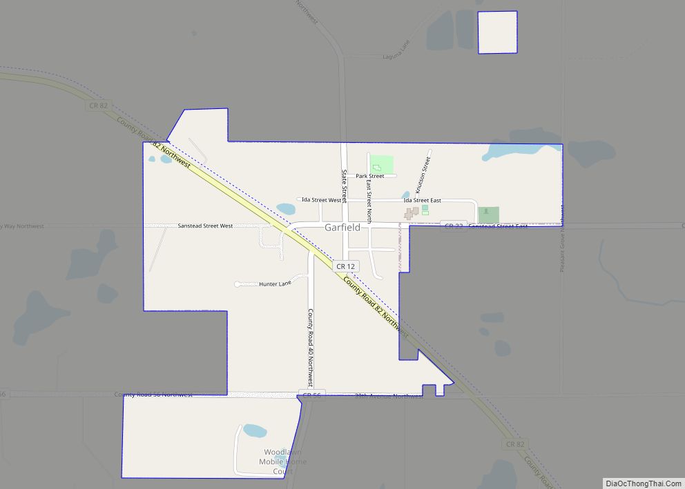
Map of Gary city, Minnesota
Gary is a city in Norman County, Minnesota, United States. The population was 227 at the 2020 census. Gary city overview: Name: Gary city LSAD Code: 25 LSAD Description: city (suffix) State: Minnesota County: Norman County Elevation: 1,099 ft (335 m) Total Area: 0.32 sq mi (0.83 km²) Land Area: 0.32 sq mi (0.83 km²) Water Area: 0.00 sq mi (0.00 km²) Total Population: 227 Population ... Read more
Map of Gary city, Minnesota
Map of Garvin city, Minnesota
Garvin is a city in Lyon County, Minnesota, United States. The population was 135 at the 2010 census. Garvin city overview: Name: Garvin city LSAD Code: 25 LSAD Description: city (suffix) State: Minnesota County: Lyon County Elevation: 1,539 ft (469 m) Total Area: 0.29 sq mi (0.75 km²) Land Area: 0.28 sq mi (0.72 km²) Water Area: 0.01 sq mi (0.03 km²) Total Population: 124 Population ... Read more
Map of Garvin city, Minnesota
Map of Garrison city, Minnesota
Garrison is a city in Crow Wing County, Minnesota, United States, along Mille Lacs Lake. The population was 210 at the 2010 census. It is part of the Brainerd Micropolitan Statistical Area. U.S. Highway 169 and Minnesota State Highway 18 are the main routes in the community. Garrison city overview: Name: Garrison city LSAD Code: ... Read more
Map of Garrison city, Minnesota
Map of Glencoe city, Minnesota
Glencoe is the county seat of McLeod County, Minnesota, United States. The population was 5,631 at the 2010 census. Glencoe city overview: Name: Glencoe city LSAD Code: 25 LSAD Description: city (suffix) State: Minnesota County: McLeod County Elevation: 997 ft (304 m) Total Area: 3.17 sq mi (8.21 km²) Land Area: 3.17 sq mi (8.20 km²) Water Area: 0.01 sq mi (0.02 km²) Total Population: 5,744 ... Read more
Map of Glencoe city, Minnesota
Map of Gilman city, Minnesota
Gilman is a city in Benton County, Minnesota, United States. The population was 224 at the 2010 census. It is part of the St. Cloud Metropolitan Statistical Area. Gilman city overview: Name: Gilman city LSAD Code: 25 LSAD Description: city (suffix) State: Minnesota County: Benton County Elevation: 1,191 ft (363 m) Total Area: 0.48 sq mi (1.24 km²) Land Area: ... Read more
Map of Gilman city, Minnesota
Map of Gilbert city, Minnesota
Gilbert is a city in St. Louis County, Minnesota, United States. The population was 1,799 at the 2010 census. State Highway 37 (MN 37) and State Highway 135 (MN 135) are two of the main routes in Gilbert. Gilbert is part of the Quad Cities, with Virginia, Eveleth, and Mountain Iron. The city is named ... Read more
Map of Gilbert city, Minnesota
Map of Gibbon city, Minnesota
Gibbon is a city in Sibley County, Minnesota, United States. The population was 772 at the 2010 census. Gibbon city overview: Name: Gibbon city LSAD Code: 25 LSAD Description: city (suffix) State: Minnesota County: Sibley County Incorporated: 1887 Elevation: 1,050 ft (320 m) Total Area: 0.66 sq mi (1.72 km²) Land Area: 0.66 sq mi (1.72 km²) Water Area: 0.00 sq mi (0.00 km²) Total Population: ... Read more
Map of Gibbon city, Minnesota
Map of Ghent city, Minnesota
Ghent (/ɡɛnt/ GHENT) is a city in Lyon County, Minnesota, United States. The population was 370 at the 2010 census. Ghent city overview: Name: Ghent city LSAD Code: 25 LSAD Description: city (suffix) State: Minnesota County: Lyon County Elevation: 1,171 ft (357 m) Total Area: 0.31 sq mi (0.81 km²) Land Area: 0.31 sq mi (0.81 km²) Water Area: 0.00 sq mi (0.00 km²) Total Population: ... Read more
Map of Ghent city, Minnesota
Map of Georgetown city, Minnesota
Georgetown is a city in Clay County, Minnesota, United States, along the Buffalo River near its confluence with the Red River of the North. The population was 86 at the 2020 census. Georgetown city overview: Name: Georgetown city LSAD Code: 25 LSAD Description: city (suffix) State: Minnesota County: Clay County Elevation: 883 ft (269 m) Total Area: ... Read more
Map of Georgetown city, Minnesota
Map of Genola city, Minnesota
Genola (/dʒɛˈnoʊlə/ jeh-NOH-lə) is a city in Morrison County, Minnesota, United States. The population was 70 at the 2020 census. Genola city overview: Name: Genola city LSAD Code: 25 LSAD Description: city (suffix) State: Minnesota County: Morrison County Elevation: 1,161 ft (354 m) Total Area: 0.31 sq mi (0.80 km²) Land Area: 0.31 sq mi (0.80 km²) Water Area: 0.00 sq mi (0.00 km²) Total Population: ... Read more
Map of Genola city, Minnesota
Map of Geneva city, Minnesota
Geneva is a city in Freeborn County, Minnesota, United States. The population was 555 at the 2010 census. Geneva city overview: Name: Geneva city LSAD Code: 25 LSAD Description: city (suffix) State: Minnesota County: Freeborn County Elevation: 1,227 ft (374 m) Total Area: 0.47 sq mi (1.23 km²) Land Area: 0.47 sq mi (1.21 km²) Water Area: 0.01 sq mi (0.01 km²) Total Population: 508 Population ... Read more
Map of Geneva city, Minnesota
Map of Gem Lake city
Gem Lake is a city in Ramsey County, Minnesota, United States. The population was 528 at the 2020 census. Gem Lake city overview: Name: Gem Lake city LSAD Code: 25 LSAD Description: city (suffix) State: Minnesota County: Ramsey County Elevation: 958 ft (292 m) Total Area: 1.11 sq mi (2.86 km²) Land Area: 1.04 sq mi (2.71 km²) Water Area: 0.06 sq mi (0.16 km²) Total ... Read more
Map of Gem Lake city