Map of Keewatin city
Keewatin (/kiˈwɑːtɪn/ kee-WAH-tin) is a city in Itasca County, Minnesota, United States. The population was 1,068 at the 2010 census. U.S. Highway 169 serves as a main route in Keewatin. Students from the Keewatin area attend Nashwauk Keewatin High School. Keewatin city overview: Name: Keewatin city LSAD Code: 25 LSAD Description: city (suffix) State: Minnesota ... Read more
Map of Keewatin city
Map of Kasson city
Kasson (/ˈkæsən/ KASS-ən) is a city in Dodge County, Minnesota, United States. The population was 6,851 at the 2020 census. The city is located 13 miles (21 km) west of Rochester along U.S. Highway 14 and is one of the endpoints of Minnesota State Highway 57. The Dakota, Minnesota and Eastern Railroad’s main freight rail line ... Read more
Map of Kasson city
Map of Kasota city
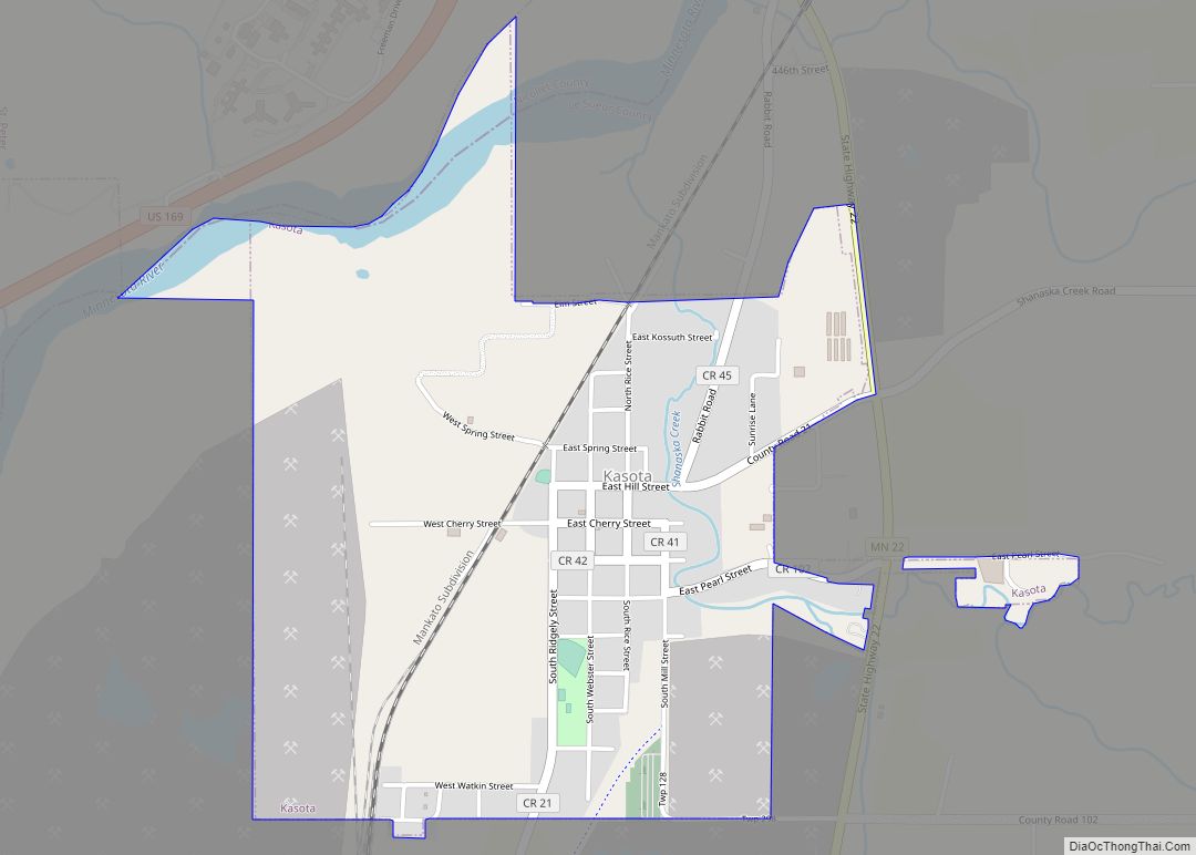
Kasota is a city within the larger Kasota Township, Le Sueur County, Minnesota, United States. The population was 714 at the 2020 census. Kasota city overview: Name: Kasota city LSAD Code: 25 LSAD Description: city (suffix) State: Minnesota County: Le Sueur County Elevation: 807 ft (246 m) Total Area: 1.28 sq mi (3.32 km²) Land Area: 1.24 sq mi (3.22 km²) Water Area: ... Read more
Map of Kasota city
Map of Kimball city, Minnesota
Kimball (/ˈkɪmbəl/ KIM-bəl) is a city in Stearns County, Minnesota, United States. The population was 799 at the 2020 census. It is part of the St. Cloud Metropolitan Statistical Area. Kimball city overview: Name: Kimball city LSAD Code: 25 LSAD Description: city (suffix) State: Minnesota County: Stearns County Elevation: 1,161 ft (354 m) Total Area: 1.51 sq mi (3.92 km²) ... Read more
Map of Kimball city, Minnesota
Map of Kilkenny city
Kilkenny is a city in Le Sueur County, Minnesota, United States. The population was 134 at the 2010 census. It was named after the city and county of Kilkenny in Ireland. Kilkenny city overview: Name: Kilkenny city LSAD Code: 25 LSAD Description: city (suffix) State: Minnesota County: Le Sueur County Elevation: 1,060 ft (323 m) Total Area: ... Read more
Map of Kilkenny city
Map of Kiester city
Kiester (/ˈkiːstər/ KEE-stər) is a city in Faribault County, Minnesota, United States. The population was 501 at the 2010 census. Kiester city overview: Name: Kiester city LSAD Code: 25 LSAD Description: city (suffix) State: Minnesota County: Faribault County Elevation: 1,253 ft (382 m) Total Area: 0.43 sq mi (1.11 km²) Land Area: 0.43 sq mi (1.11 km²) Water Area: 0.00 sq mi (0.00 km²) Total Population: ... Read more
Map of Kiester city
Map of Kettle River city
Kettle River is a city in Carlton County, Minnesota, along the Kettle River, for which it was named. The population was 180 at the time of the 2010 census. It was incorporated in 1921. Minnesota State Highway 73 serves as a main route in Kettle River. Kettle River city overview: Name: Kettle River city LSAD ... Read more
Map of Kettle River city
Map of Kerrick city
Kerrick (/ˈkɛrɪk/ KERR-ik) is a city in Pine County, Minnesota, United States. The population was 65 at the 2010 census. Minnesota State Highway 23 serves as a main route in the community. Kerrick city overview: Name: Kerrick city LSAD Code: 25 LSAD Description: city (suffix) State: Minnesota County: Pine County Incorporated: October 22, 1946 Elevation: ... Read more
Map of Kerrick city
Map of Kerkhoven city
Kerkhoven (/ˈkɜːrkhoʊvən/ KURK-hoh-vən) is a city in Swift County, Minnesota, United States, located roughly 100 miles (160 km) west of the Twin Cities region of Minneapolis/St. Paul along U.S. Route 12. The population was 759 at the 2010 census. Kerkhoven city overview: Name: Kerkhoven city LSAD Code: 25 LSAD Description: city (suffix) State: Minnesota County: Swift ... Read more
Map of Kerkhoven city
Map of Kenyon city
Kenyon (/ˈkɛnjən/ KEN-yən) is a city in southwestern Goodhue County, Minnesota, United States, located along the North Fork of the Zumbro River. It was founded in 1856 and named in honor of Kenyon College. It is known for the Boulevard of roses on main street, which is the namesake of the town festival “Rosefest” held ... Read more
Map of Kenyon city
Map of Kent city, Minnesota
Kent is a city in Wilkin County, Minnesota, United States. The population was 65 at the 2020 census. It is part of the Wahpeton, ND–MN Micropolitan Statistical Area. Kent city overview: Name: Kent city LSAD Code: 25 LSAD Description: city (suffix) State: Minnesota County: Wilkin County Elevation: 945 ft (288 m) Total Area: 0.19 sq mi (0.50 km²) Land Area: ... Read more
Map of Kent city, Minnesota
Map of Kensington city, Minnesota
Kensington is a city in Douglas County, Minnesota, United States. The population was 266 at the 2020 census. The city is notable in Minnesota history for being the place where the Kensington Runestone was first displayed. It is now at a museum in nearby Alexandria, Minnesota. Kensington city overview: Name: Kensington city LSAD Code: 25 ... Read more
Map of Kensington city, Minnesota