Map of Gunnison town, Mississippi

Map of Gunnison town, Mississippi

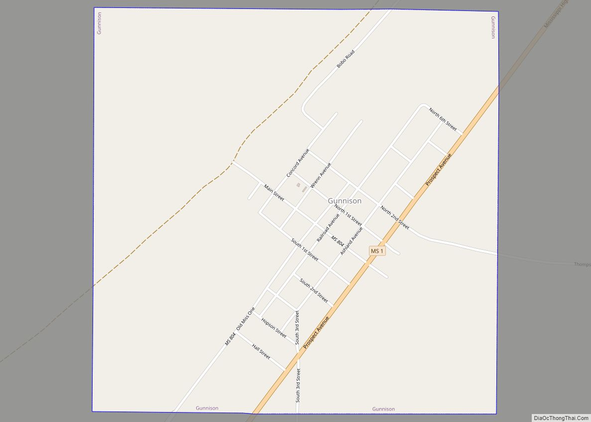
Gunnison is a town in Bolivar County, Mississippi, United States. Per the 2020 census, the population was 295. The mayor is Frances L. Ward. Gunnison town overview: Name: Gunnison town LSAD Code: 43 LSAD Description: town (suffix) State: Mississippi County: Bolivar County Elevation: 151 ft (46 m) Total Area: 1.00 sq mi (2.59 km²) Land Area: 0.98 sq mi (2.54 km²) Water Area: … Read more

Map of Gulf Park Estates CDP

Map of Gulf Park Estates CDP

Gulf Park Estates is an unincorporated community and census-designated place (CDP) located south of Ocean Springs in Jackson County, Mississippi, United States. It is part of the Pascagoula Metropolitan Statistical Area. The population was 5,719 at the 2010 census, up from 4,272 at the 2000 census. Gulf Park Estates CDP overview: Name: Gulf Park Estates … Read more

Map of Gulf Hills CDP

Map of Gulf Hills CDP

Gulf Hills is an unincorporated community and census-designated place (CDP) in Jackson County, Mississippi, United States. It is part of the Pascagoula Metropolitan Statistical Area. The population was 8,526 at the 2020 census, up from 7,144 at the 2010 census. Gulf Hills CDP overview: Name: Gulf Hills CDP LSAD Code: 57 LSAD Description: CDP (suffix) … Read more

Map of Grenada city, Mississippi

Map of Grenada city, Mississippi

Grenada /ɡrəˈneɪdə/ is a city in Grenada County, Mississippi, United States. The population was 13,092 at the 2010 census. It is the county seat of Grenada County. Grenada city overview: Name: Grenada city LSAD Code: 25 LSAD Description: city (suffix) State: Mississippi County: Grenada County Elevation: 213 ft (65 m) Total Area: 30.03 sq mi (77.78 km²) Land Area: 30.01 sq mi … Read more

Map of Helena CDP, Mississippi

Map of Helena CDP, Mississippi

Helena is an unincorporated community and census-designated place (CDP) in Jackson County, Mississippi, United States. It is part of the Moss Point Metropolitan Statistical Area. Per the 2020 Census, the population was 983. Helena CDP overview: Name: Helena CDP LSAD Code: 57 LSAD Description: CDP (suffix) State: Mississippi County: Jackson County Elevation: 10 ft (3 m) Total … Read more

Map of Heidelberg town, Mississippi

Map of Heidelberg town, Mississippi

Heidelberg is a town in Jasper County, Mississippi, United States. The population was 718 at the 2010 census, down from 840 at the 2000 census. Heidelberg town overview: Name: Heidelberg town LSAD Code: 43 LSAD Description: town (suffix) State: Mississippi County: Jasper County Elevation: 344 ft (105 m) Total Area: 5.13 sq mi (13.29 km²) Land Area: 5.11 sq mi (13.24 km²) Water … Read more

Map of Hazlehurst city, Mississippi

Map of Hazlehurst city, Mississippi

Hazlehurst is a city in and the county seat of Copiah County, Mississippi, United States, located about 30 miles (48 km) south of the state capital Jackson along Interstate 55. The population was 4,009 at the 2010 census. It is part of the Jackson Metropolitan Statistical Area. Its economy is based on agriculture, particularly tomatoes and … Read more

Map of Hatley town

Map of Hatley town, Mississippi

Hatley is a town in Monroe County, Mississippi. The population was 482 at the 2010 census. Hatley town overview: Name: Hatley town LSAD Code: 43 LSAD Description: town (suffix) State: Mississippi County: Monroe County Elevation: 351 ft (107 m) Total Area: 1.37 sq mi (3.54 km²) Land Area: 1.37 sq mi (3.54 km²) Water Area: 0.00 sq mi (0.00 km²) Total Population: 495 Population Density: 362.37/sq mi … Read more

Map of Hamilton CDP, Mississippi

Map of Hamilton CDP, Mississippi

Hamilton is a census-designated place and unincorporated community in Monroe County, Mississippi. Hamilton is located on U.S. Route 45, east of the Tennessee–Tombigbee Waterway, 12 mi (19 km) north of Columbus Air Force Base. The third largest titanium dioxide manufacturing operation in the world is located in Hamilton. Hamilton CDP overview: Name: Hamilton CDP LSAD Code: 57 … Read more

Map of Hide-A-Way Lake CDP

Map of Hide-A-Way Lake CDP

Hide-A-Way Lake is an unincorporated community and census-designated place in Pearl River County, Mississippi, United States. Its population was 2,065 as of the 2020 census. Hide-A-Way Lake CDP overview: Name: Hide-A-Way Lake CDP LSAD Code: 57 LSAD Description: CDP (suffix) State: Mississippi County: Pearl River County Elevation: 102 ft (31 m) Total Area: 1.825 sq mi (4.73 km²) Land Area: … Read more

Map of Hickory town, Mississippi

Map of Hickory town, Mississippi

Hickory is a town in Newton County, Mississippi. The population was 530 at the 2010 census. The town is named after Andrew Jackson, nicknamed “Old Hickory,” who passed through the area on his way to fight the Battle of New Orleans during the War of 1812. Hickory town overview: Name: Hickory town LSAD Code: 43 … Read more

Map of Hickory Flat town

Map of Hickory Flat town

Hickory Flat is a town in Benton County, Mississippi, United States. The population was 601 at the 2010 census. Hickory Flat town overview: Name: Hickory Flat town LSAD Code: 43 LSAD Description: town (suffix) State: Mississippi County: Benton County Elevation: 423 ft (129 m) Total Area: 0.96 sq mi (2.48 km²) Land Area: 0.96 sq mi (2.48 km²) Water Area: 0.00 sq mi (0.00 km²) Total … Read more