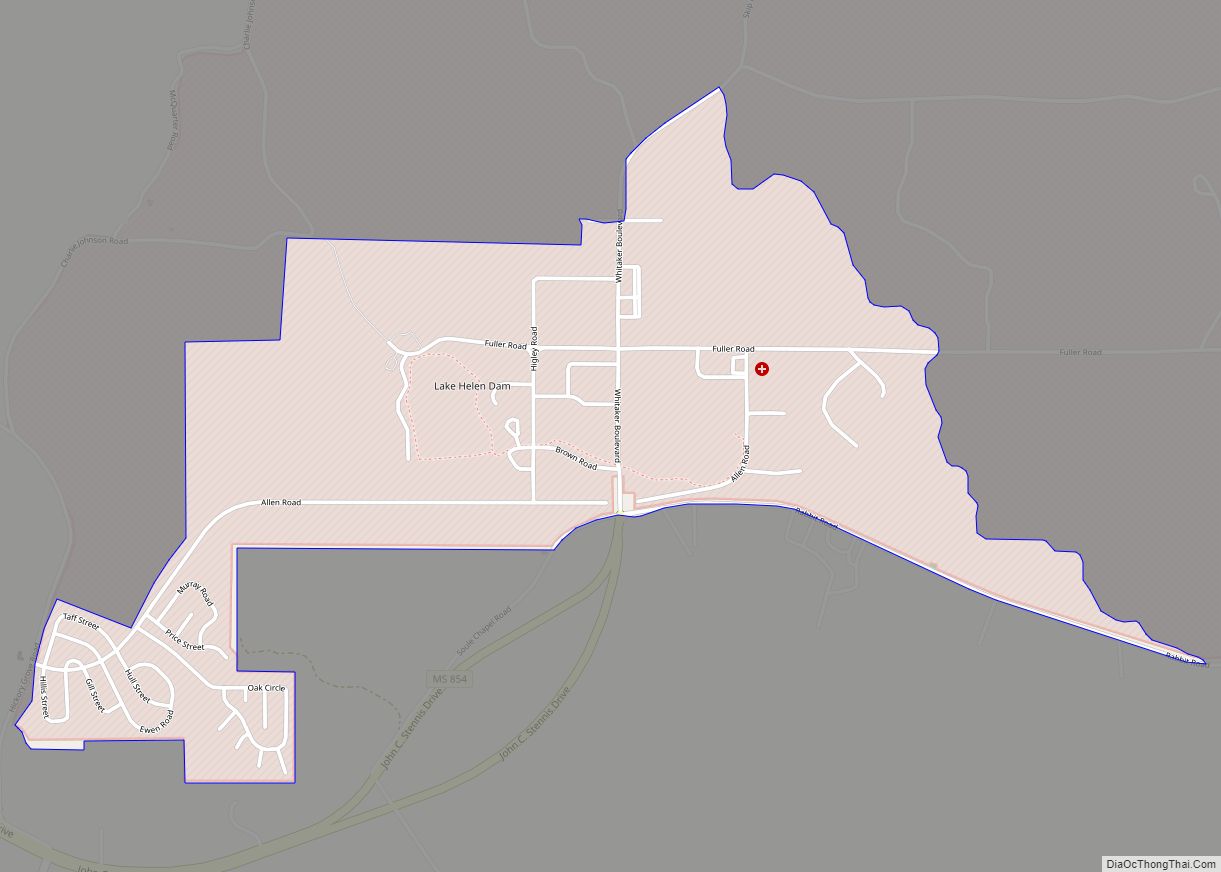
Map of Mendenhall city

Map of Mendenhall city

Mendenhall is a city in Simpson County, Mississippi, United States. The population was 2,504 at the 2010 census. It is the county seat of Simpson County. Mendenhall is part of the Jackson Metropolitan Statistical Area. Mendenhall has one of the highest trained volunteer fire depts in the area. Mendenhall has 1 full-time fire marshall. Of … Read more

Map of Meadville town, Mississippi

Map of Meadville town, Mississippi

Meadville is a town in and the county seat of Franklin County, Mississippi, United States, in the southwest part of the state. The population was 449 at the 2010 census, down from 519 at the 2000 census. It is situated north of the Homochitto River, which runs from the northeast to the southwest through the … Read more

Map of Mize town

Map of Mize town

Mize is a town in Smith County, Mississippi, United States. The population was 285 at the 2000 census. It is the home of the Mississippi Watermelon Festival. Mize town overview: Name: Mize town LSAD Code: 43 LSAD Description: town (suffix) State: Mississippi County: Smith County Elevation: 295 ft (90 m) Total Area: 2.44 sq mi (6.32 km²) Land Area: 2.44 sq mi … Read more

Map of Mississippi Valley State University CDP

Map of Mississippi Valley State University CDP

Mississippi Valley State University is a census-designated place in Leflore County, Mississippi, United States. The population at the 2020 census was 805. It is the location of Mississippi Valley State University and is adjacent to Itta Bena. Mississippi Valley State University CDP overview: Name: Mississippi Valley State University CDP LSAD Code: 57 LSAD Description: CDP … Read more

Map of Mississippi State CDP

Map of Mississippi State CDP

Mississippi State, Mississippi is a census-designated place in Oktibbeha County, Mississippi, United States. It is the official designated name for the area encompassing Mississippi State University, which lies partly in the nearby incorporated municipality of Starkville. The population at the 2020 census was 4,968. United States Postal Service designation is “Mississippi State, Mississippi 39762”. Mississippi … Read more

Map of Metcalfe town

Map of Metcalfe town

Metcalfe is a town in Washington County, Mississippi, United States. The population was 1,067 at the 2010 census. The county is located on the western border of the state, with the Mississippi River on the west. It is within the Mississippi Delta. Metcalfe town overview: Name: Metcalfe town LSAD Code: 43 LSAD Description: town (suffix) … Read more

Map of Monticello town, Mississippi

Map of Monticello town, Mississippi

Monticello is a town in and the county seat of Lawrence County, Mississippi, United States. The population was 1,571 at the 2010 census. Monticello town overview: Name: Monticello town LSAD Code: 43 LSAD Description: town (suffix) State: Mississippi County: Lawrence County Elevation: 194 ft (59 m) Total Area: 4.26 sq mi (11.04 km²) Land Area: 4.17 sq mi (10.80 km²) Water Area: 0.09 sq mi … Read more

Map of Morgantown CDP, Mississippi

Map of Morgantown CDP, Mississippi

Morgantown is a census-designated place (CDP) in Adams County, Mississippi, United States, located to the northeast of the city of Natchez. As of the 2020 census, it had a population of 1,334. The community is located 4 miles (6 km) east of downtown Natchez, slightly north of U.S. Route 84, and is centered on Morgantown Road. … Read more

Map of Morgan City town, Mississippi

Map of Morgan City town, Mississippi

Morgan City, Mississippi is a town in Leflore County along Mississippi Highway 7. The population was 255 at the 2010 census, down from 305 at the 2000 census. It is part of the Greenwood, Mississippi micropolitan area. Morgan City town overview: Name: Morgan City town LSAD Code: 43 LSAD Description: town (suffix) State: Mississippi County: … Read more

Map of Moorhead city, Mississippi

Map of Moorhead city, Mississippi

Moorhead is a city in Sunflower County, Mississippi, United States. As of the 2010 census, the city population was 2,405. Moorhead city overview: Name: Moorhead city LSAD Code: 25 LSAD Description: city (suffix) State: Mississippi County: Sunflower County Elevation: 115 ft (35 m) Total Area: 1.29 sq mi (3.35 km²) Land Area: 1.29 sq mi (3.35 km²) Water Area: 0.00 sq mi (0.00 km²) Total Population: … Read more

Map of Mooreville CDP

Map of Mooreville CDP

Mooreville, sometimes misspelled as Mooresville, is an unincorporated community and census-designated place (CDP) in Lee County, Mississippi, United States. As of the 2010 census the population was 650. Mooreville is part of the Tupelo Micropolitan Statistical Area. It has a post office and a ZIP code (38857). Mooreville CDP overview: Name: Mooreville CDP LSAD Code: … Read more

Map of Montrose town, Mississippi

Map of Montrose town, Mississippi

Montrose is a town in Jasper County, Mississippi, United States. The population was 140 at the 2010 census. Montrose town overview: Name: Montrose town LSAD Code: 43 LSAD Description: town (suffix) State: Mississippi County: Jasper County Elevation: 430 ft (131 m) Total Area: 2.71 sq mi (7.03 km²) Land Area: 2.71 sq mi (7.03 km²) Water Area: 0.00 sq mi (0.00 km²) Total Population: 104 Population … Read more