Map of Scooba town

Map of Scooba town

Scooba is a town in Kemper County, Mississippi, United States. The population was 732 as of the 2010 Census. Scooba town overview: Name: Scooba town LSAD Code: 43 LSAD Description: town (suffix) State: Mississippi County: Kemper County Elevation: 213 ft (65 m) Total Area: 2.48 sq mi (6.42 km²) Land Area: 2.48 sq mi (6.42 km²) Water Area: 0.00 sq mi (0.00 km²) Total Population: 744 … Read more

Map of Schlater town

Map of Schlater town

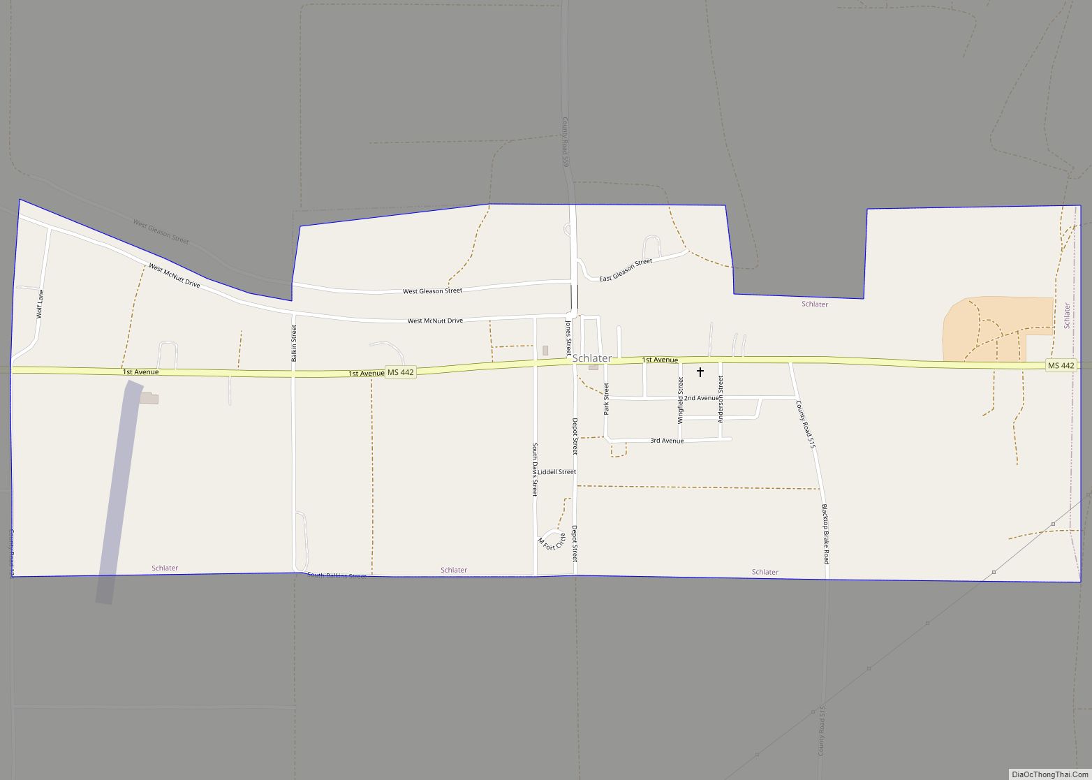
Schlater is a town in Leflore County, Mississippi, United States. The population was 310 at the 2010 census, down from 388 at the 2000 census. It is part of the Greenwood, Mississippi micropolitan area. Schlater town overview: Name: Schlater town LSAD Code: 43 LSAD Description: town (suffix) State: Mississippi County: Leflore County Elevation: 128 ft (139 m) … Read more

Map of Senatobia city

Map of Senatobia city

Senatobia is a city in, and the county seat of, Tate County, Mississippi, United States, and is the 16th largest municipality in the Memphis Metropolitan Area. The population was 8,165 at the 2010 census. Senatobia is home to Northwest Mississippi Community College, a state community college providing two-year academic and technical degree programs. Northwest’s system-wide … Read more

Map of Sherman town, Mississippi

Map of Sherman town, Mississippi

Sherman is a town which straddles Lee, Pontotoc, and Union counties in Mississippi. The population was 600 at the 2020 census. Sherman town overview: Name: Sherman town LSAD Code: 43 LSAD Description: town (suffix) State: Mississippi County: Lee County, Pontotoc County, Union County Elevation: 364 ft (111 m) Total Area: 1.74 sq mi (4.51 km²) Land Area: 1.74 sq mi (4.51 km²) Water … Read more

Map of Shelby city, Mississippi

Map of Shelby city, Mississippi

Shelby is a city in Bolivar County, Mississippi, United States. The population was 2,229 at the 2010 census, down from 2,926 in 2000. The town of Shelby was established in 1853 by Tom Shelby, who had purchased a block of land there from the federal government. Shelby city overview: Name: Shelby city LSAD Code: 25 … Read more

Map of Shaw city

Map of Shaw city

Shaw is a city in Bolivar and Sunflower counties, Mississippi, United States, located in the Mississippi Delta region. The name was derived from an old Indian tribe northeast of this region. The population was 1,952 at the 2010 census. Shaw city overview: Name: Shaw city LSAD Code: 25 LSAD Description: city (suffix) State: Mississippi County: … Read more

Map of Sharon CDP, Mississippi

Map of Sharon CDP, Mississippi

Sharon is an unincorporated community and census-designated place (CDP) in Jones County, Mississippi, United States. The population was 1,344 at the 2020 census. It is part of the Laurel micropolitan statistical area. Sharon CDP overview: Name: Sharon CDP LSAD Code: 57 LSAD Description: CDP (suffix) State: Mississippi County: Jones County Elevation: 315 ft (96 m) Total Area: … Read more

Map of Shannon town, Mississippi

Map of Shannon town, Mississippi

Shannon is a town in Lee County, Mississippi. The population was 1,496 at the 2020 Census. Shannon is located on Mississippi Highway 145, west of U.S. Route 45. Chiwapa Creek flows south of the town. Shannon town overview: Name: Shannon town LSAD Code: 43 LSAD Description: town (suffix) State: Mississippi County: Lee County Elevation: 256 ft … Read more

Map of Silver Creek town, Mississippi

Map of Silver Creek town, Mississippi

Silver Creek is a town in Lawrence County, Mississippi, United States. The population was 210 at the 2010 census. Silver Creek is accessed from U.S. Route 84 and Mississippi Highway 43. The film Jesse James’ Women (1954) was filmed in Silver Creek. Silver Creek town overview: Name: Silver Creek town LSAD Code: 43 LSAD Description: … Read more

Map of Silver City town, Mississippi

Map of Silver City town, Mississippi

Silver City is a town in Humphreys County, Mississippi, United States. The population was 217 at the 2021 census, a massive decline from the 2000 census. Silver City town overview: Name: Silver City town LSAD Code: 43 LSAD Description: town (suffix) State: Mississippi County: Humphreys County Elevation: 108 ft (33 m) Total Area: 0.63 sq mi (1.62 km²) Land Area: … Read more

Map of Sidon town

Map of Sidon town

Sidon is a town in Leflore County, Mississippi, United States. The population was 509 at the 2010 census. It is part of the Greenwood, Mississippi micropolitan area. Sidon town overview: Name: Sidon town LSAD Code: 43 LSAD Description: town (suffix) State: Mississippi County: Leflore County Elevation: 125 ft (38 m) Total Area: 0.12 sq mi (0.32 km²) Land Area: 0.12 sq mi … Read more

Map of Shuqualak town

Map of Shuqualak town

Shuqualak, pronounced “sugar lock”, is a town in Noxubee County, Mississippi, United States. As of the 2020 census, the population was 399. That is down from 501 from the 2010 census. Three locations in Shuqualak, including most of the downtown area, are included on the National Register of Historic Places. Shuqualak town overview: Name: Shuqualak … Read more