Map of Webb town, Mississippi

Map of Webb town, Mississippi

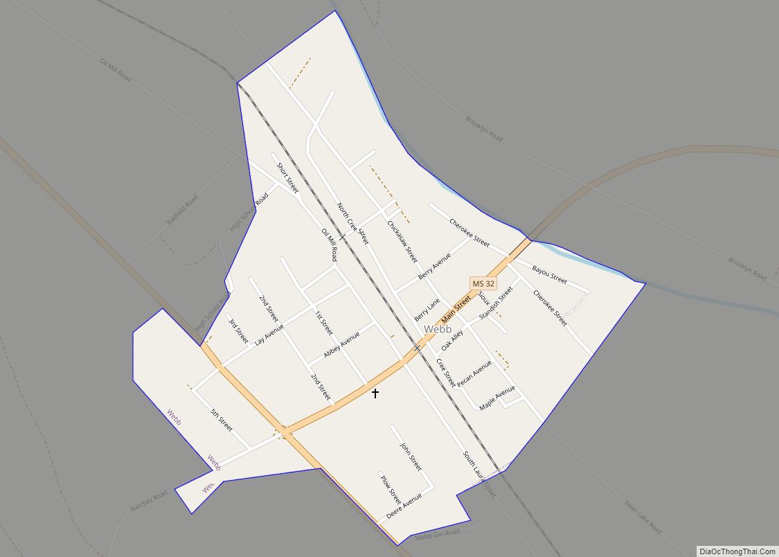
Webb is a town in Tallahatchie County, Mississippi. The population was 565 at the 2010 census. Webb town overview: Name: Webb town LSAD Code: 43 LSAD Description: town (suffix) State: Mississippi County: Tallahatchie County Elevation: 151 ft (46 m) Total Area: 0.42 sq mi (1.09 km²) Land Area: 0.42 sq mi (1.09 km²) Water Area: 0.00 sq mi (0.00 km²) Total Population: 416 Population Density: 985.78/sq mi … Read more

Map of Waynesboro city, Mississippi

Map of Waynesboro city, Mississippi

Waynesboro is a city in Wayne County, Mississippi, United States. The population was 5,043 at the 2010 census. It is the county seat of Wayne County. Waynesboro city overview: Name: Waynesboro city LSAD Code: 25 LSAD Description: city (suffix) State: Mississippi County: Wayne County Elevation: 190 ft (58 m) Total Area: 12.70 sq mi (32.90 km²) Land Area: 12.69 sq mi (32.87 km²) … Read more

Map of Waveland city, Mississippi

Map of Waveland city, Mississippi

Waveland is a city located in Hancock County, Mississippi, United States, on the Gulf of Mexico. It is part of the Gulfport–Biloxi, Mississippi Metropolitan Statistical Area. The city of Waveland was incorporated in 1972. As of the 2010 census, the city had a population of 6,435. Waveland was nearly destroyed by Hurricane Camille on August … Read more

Map of Wiggins city, Mississippi

Map of Wiggins city, Mississippi

Wiggins is a city in and the county seat of Stone County, Mississippi, United States. It is part of the Gulfport–Biloxi, Mississippi Metropolitan Statistical Area. The population was 4,272 at the 2020 census. Wiggins city overview: Name: Wiggins city LSAD Code: 25 LSAD Description: city (suffix) State: Mississippi County: Stone County Elevation: 262 ft (80 m) Total … Read more

Map of White Oak CDP, Mississippi

Map of White Oak CDP, Mississippi

White Oak is a census-designated place located on Mississippi Highway 4 in Tunica County, Mississippi. White Oak is approximately 2 miles (3.2 km) east of Evansville and approximately 8 miles (13 km) west of Savage. The population at the 2020 census was 692. White Oak CDP overview: Name: White Oak CDP LSAD Code: 57 LSAD Description: CDP … Read more

Map of West town

Map of West town, Mississippi

West is a town in northeastern Holmes County, Mississippi, United States. Per the 2020 census, the population was 153. The Mayor of West, MS as of December 2020 is Michael Fancher. West town overview: Name: West town LSAD Code: 43 LSAD Description: town (suffix) State: Mississippi County: Holmes County Elevation: 292 ft (89 m) Total Area: 0.56 sq mi … Read more

Map of West Point city, Mississippi

Map of West Point city, Mississippi

West Point is a city in Clay County, Mississippi, United States, in the Golden Triangle region of the state. The population was 11,307 at the 2010 census. It is the county seat of Clay County and the principal city of the West Point Micropolitan Statistical Area, which is part of the larger Columbus-West Point Combined … Read more

Map of West Hattiesburg CDP

Map of West Hattiesburg CDP

West Hattiesburg is an unincorporated area and census-designated place (CDP) in Lamar County, Mississippi, west of the city of Hattiesburg and east of the community of Oak Grove. It is part of the Hattiesburg metropolitan area. It had a decline in population from 6,305 at the 2000 census to 5,909 at the 2010 census. West … Read more

Map of Winstonville town

Map of Winstonville town

Winstonville is a town in Bolivar County, Mississippi, United States. Per the 2020 census, the population was 153. Winstonville town overview: Name: Winstonville town LSAD Code: 43 LSAD Description: town (suffix) State: Mississippi County: Bolivar County Elevation: 144 ft (44 m) Total Area: 0.29 sq mi (0.76 km²) Land Area: 0.29 sq mi (0.76 km²) Water Area: 0.00 sq mi (0.00 km²) Total Population: 153 Population … Read more

Map of Winona city, Mississippi

Map of Winona city, Mississippi

Winona is a city in Montgomery County, Mississippi, United States. The population was 5,043 at the 2010 census. It is the county seat of Montgomery County. Winona is known in the local area as “The Crossroads of North Mississippi”; the intersection of U.S. Interstate 55 and U.S. Highways 51 and 82 were constructed here. Winona … Read more

Map of Yazoo City city

Map of Yazoo City

Yazoo City is a U.S. city in Yazoo County, Mississippi. It was named after the Yazoo River, which, in turn was named by the French explorer Robert La Salle in 1682 as “Rivière des Yazous” in reference to the Yazoo tribe living near the river’s mouth. It is the county seat of Yazoo County and … Read more

Map of Woodville town, Mississippi

Map of Woodville town, Mississippi

Woodville is one of the oldest towns in Mississippi and is the county seat of Wilkinson County, Mississippi, United States. Its population as of 2020 was 928. Woodville town overview: Name: Woodville town LSAD Code: 43 LSAD Description: town (suffix) State: Mississippi County: Wilkinson County Elevation: 404 ft (123 m) Total Area: 1.04 sq mi (2.68 km²) Land Area: 1.04 sq mi … Read more