Map of Columbia city, Mississippi

Map of Columbia city, Mississippi

Columbia is a U.S. city in and the county seat of Marion County, Mississippi, which was formed six years before Mississippi was admitted to statehood. Columbia was named for Columbia, South Carolina, from which many of the early settlers had migrated. The population was 6,582 as of the 2010 census, and 5,864 in 2020. Columbia … Read more

Map of Conehatta CDP

Map of Conehatta CDP

Conehatta is a census-designated place (CDP) in Newton County, Mississippi. The population was 997 at the 2000 census. It is one of the eight communities included in the Mississippi Band of Choctaw Indians Reservation and the population is 76% Choctaw. The community takes its name from Conehatta Creek. Conehatta CDP overview: Name: Conehatta CDP LSAD … Read more

Map of Como town, Mississippi

Map of Como town, Mississippi

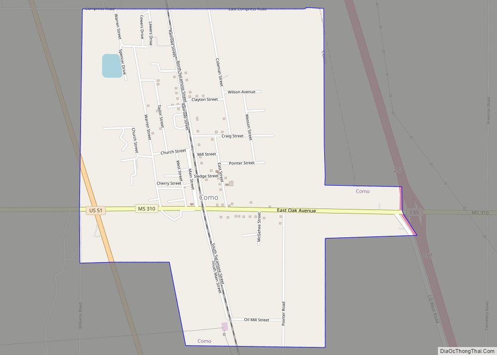
Como is a town in Panola County, Mississippi, which borders the Mississippi Delta and is in the northern part of the state, known as hill country. The population was 1,279 as of the 2010 census. Como town overview: Name: Como town LSAD Code: 43 LSAD Description: town (suffix) State: Mississippi County: Panola County Elevation: 358 ft … Read more

Map of Columbus city, Mississippi

Map of Columbus city, Mississippi

Columbus is a city in and the county seat of Lowndes County, on the eastern border of Mississippi, United States, located primarily east, but also north and northeast of the Tombigbee River, which is also part of the Tennessee-Tombigbee Waterway. It is approximately 146 miles (235 km) northeast of Jackson, 92 miles (148 km) north of Meridian, … Read more

Map of Crosby town, Mississippi

Map of Crosby town, Mississippi

Crosby is a town in Amite and Wilkinson counties, Mississippi, United States. It is part of the McComb, Mississippi micropolitan statistical area. Its population was 242 at the 2020 census. Crosby town overview: Name: Crosby town LSAD Code: 43 LSAD Description: town (suffix) State: Mississippi County: Amite County, Wilkinson County Elevation: 171 ft (52 m) Total Area: … Read more

Map of Crenshaw town

Map of Crenshaw town, Mississippi

Crenshaw is a town in Panola and Quitman counties in the U.S. state of Mississippi. The population was 885 at the 2010 census. Crenshaw town overview: Name: Crenshaw town LSAD Code: 43 LSAD Description: town (suffix) State: Mississippi County: Panola County, Quitman County Elevation: 180 ft (55 m) Total Area: 0.41 sq mi (1.06 km²) Land Area: 0.41 sq mi (1.06 km²) Water … Read more

Map of Crawford town, Mississippi

Map of Crawford town, Mississippi

Crawford is a small town in Lowndes County, Mississippi, United States. The population was 641 at the 2010 census. Crawford town overview: Name: Crawford town LSAD Code: 43 LSAD Description: town (suffix) State: Mississippi County: Lowndes County Elevation: 312 ft (95 m) Total Area: 1.40 sq mi (3.63 km²) Land Area: 1.40 sq mi (3.63 km²) Water Area: 0.00 sq mi (0.00 km²) Total Population: 415 … Read more

Map of Courtland town, Mississippi

Map of Courtland town, Mississippi

Courtland is a town in Panola County, Mississippi. The population was 511 at the time of the 2010 census. Courtland town overview: Name: Courtland town LSAD Code: 43 LSAD Description: town (suffix) State: Mississippi County: Panola County Elevation: 253 ft (77 m) Total Area: 1.10 sq mi (2.86 km²) Land Area: 1.10 sq mi (2.86 km²) Water Area: 0.00 sq mi (0.00 km²) Total Population: 470 … Read more

Map of Corinth city, Mississippi

Map of Corinth city, Mississippi

Corinth is a city in and the county seat of Alcorn County, Mississippi, United States. The population was 14,573 at the 2010 census. Its ZIP codes are 38834 and 38835. It lies on the state line with Tennessee. Corinth city overview: Name: Corinth city LSAD Code: 25 LSAD Description: city (suffix) State: Mississippi County: Alcorn … Read more

Map of D'Lo town

Map of D’Lo town

D’Lo is a town in Simpson County, Mississippi, United States, along the Strong River. The population was 452 at the 2010 census. It is part of the Jackson, Mississippi metropolitan area. The town was featured in Life magazine for sending more men per capita to serve in World War II than any other town of … Read more

Map of D'Iberville city

Map of D’Iberville city

D’Iberville (/diˈaɪbərvɪl/ dee-EYE-bər-vil) is a city in Harrison County, Mississippi, United States, immediately north of Biloxi, across the Back Bay. As of the 2010 United States Census, it had a population of 9,486. It is part of the Gulfport–Biloxi Metropolitan Statistical Area. D’Iberville city overview: Name: D’Iberville city LSAD Code: 25 LSAD Description: city (suffix) … Read more

Map of Crystal Springs city, Mississippi

Map of Crystal Springs city, Mississippi

Crystal Springs is a city in Copiah County, Mississippi, United States. The population was 5,044 as of the 2010 census, down from 5,873 in 2000. It is part of the Jackson Metropolitan Statistical Area. Crystal Springs city overview: Name: Crystal Springs city LSAD Code: 25 LSAD Description: city (suffix) State: Mississippi County: Copiah County Elevation: … Read more