Map of Cairo village, Missouri

Map of Cairo village, Missouri

Cairo is a village in Randolph County, Missouri, United States. The population was 292 at the 2010 census. The pronunciation is Ka-row, unlike the city in Egypt. Cairo village overview: Name: Cairo village LSAD Code: 47 LSAD Description: village (suffix) State: Missouri County: Randolph County Elevation: 860 ft (260 m) Total Area: 0.30 sq mi (0.78 km²) Land Area: 0.30 sq mi … Read more

Map of Cainsville city

Map of Cainsville city

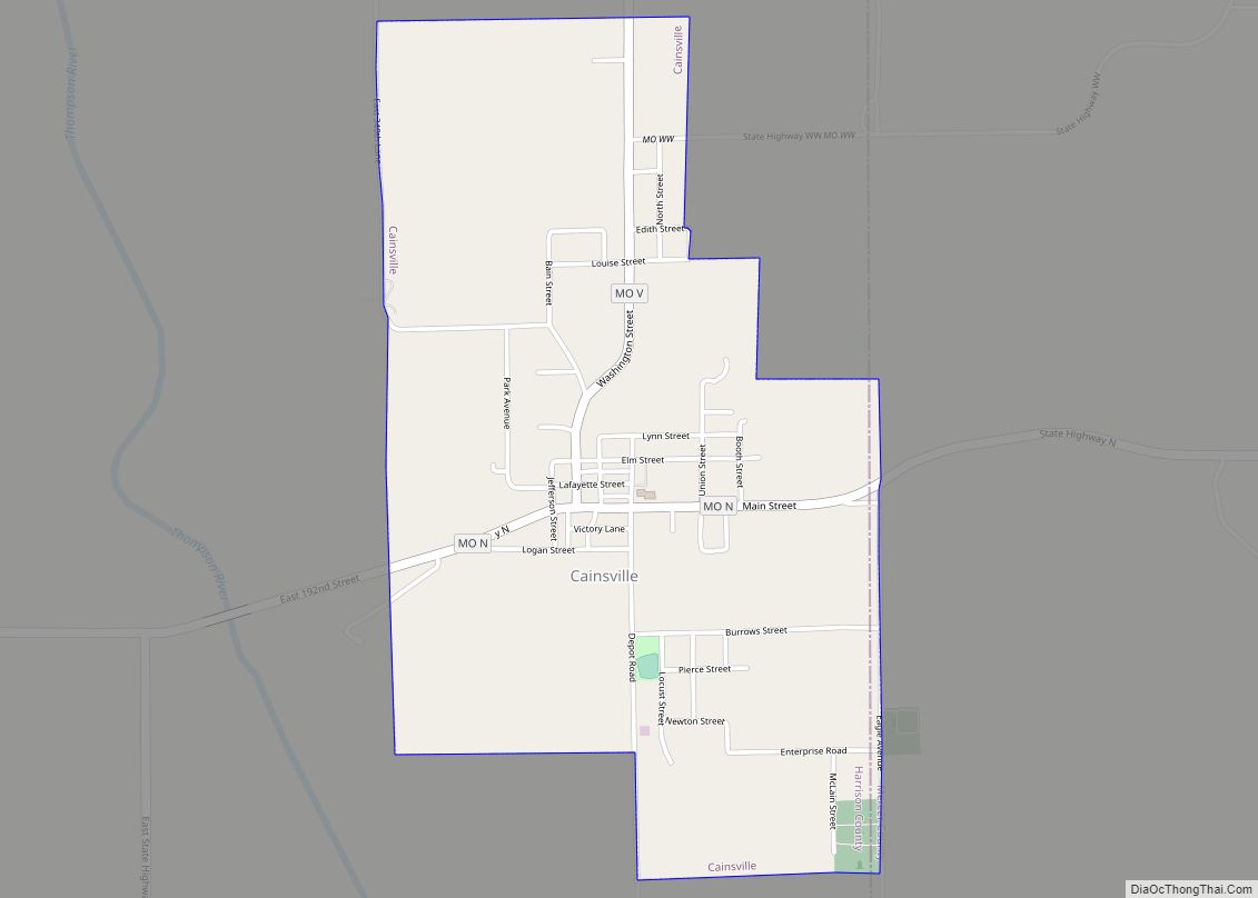
Cainsville is a city in eastern Harrison County, Missouri, United States. The population was 283 at the 2020 census. Cainsville city overview: Name: Cainsville city LSAD Code: 25 LSAD Description: city (suffix) State: Missouri County: Harrison County Elevation: 869 ft (265 m) Total Area: 1.37 sq mi (3.55 km²) Land Area: 1.37 sq mi (3.55 km²) Water Area: 0.00 sq mi (0.00 km²) Total Population: 283 … Read more

Map of California city, Missouri

Map of California city, Missouri

California is a city in and the county seat of Moniteau County, Missouri, United States. The 2010 census has the population at 4,278. California is the third largest city in the Jefferson City, Missouri Metropolitan Statistical Area, as well as the largest city in Moniteau County. California city overview: Name: California city LSAD Code: 25 … Read more

Map of Calhoun city, Missouri

Map of Calhoun city, Missouri

Calhoun is a city in Henry County, Missouri, United States. The population was 469 at the 2010 census. Calhoun city overview: Name: Calhoun city LSAD Code: 25 LSAD Description: city (suffix) State: Missouri County: Henry County Elevation: 781 ft (238 m) Total Area: 0.99 sq mi (2.58 km²) Land Area: 0.98 sq mi (2.55 km²) Water Area: 0.01 sq mi (0.03 km²) Total Population: 392 Population … Read more

Map of Caledonia village, Missouri

Map of Caledonia village, Missouri

Caledonia is a village in southern Washington County, Missouri, United States. The population was 131 at the 2020 census. Caledonia is located 4 miles (6.4 km) east of Belgrade. Caledonia village overview: Name: Caledonia village LSAD Code: 47 LSAD Description: village (suffix) State: Missouri County: Washington County Elevation: 902 ft (275 m) Total Area: 0.16 sq mi (0.42 km²) Land Area: … Read more

Map of Camden Point city

Map of Camden Point city

Camden Point is a city in Platte County, Missouri, United States and is part of the Kansas City metropolitan area. The population was 474 at the 2010 census. Camden Point city overview: Name: Camden Point city LSAD Code: 25 LSAD Description: city (suffix) State: Missouri County: Platte County Elevation: 935 ft (285 m) Total Area: 0.64 sq mi (1.66 km²) … Read more

Map of Calverton Park city

Map of Calverton Park city

Calverton Park is a city in St. Louis County, Missouri, United States. The population was 1,293 at the 2010 census. The Village of Calverton Park incorporated as the City of Calverton Park in 2014. Calverton Park city overview: Name: Calverton Park city LSAD Code: 25 LSAD Description: city (suffix) State: Missouri County: St. Louis County … Read more

Map of Callao city

Map of Callao city

Callao is a city in Macon County, Missouri, United States. The population was 251 at the 2020 census. Callao city overview: Name: Callao city LSAD Code: 25 LSAD Description: city (suffix) State: Missouri County: Macon County Elevation: 837 ft (255 m) Total Area: 0.52 sq mi (1.34 km²) Land Area: 0.52 sq mi (1.34 km²) Water Area: 0.00 sq mi (0.00 km²) Total Population: 251 Population … Read more

Map of Cameron city, Missouri

Map of Cameron city, Missouri

Cameron is a city in Clinton, DeKalb and Caldwell counties in the U.S. state of Missouri. The population was 8,513 at the 2020 census. The Clinton and Caldwell counties portion of Cameron are part of the Kansas City, MO–KS Metropolitan Statistical Area, while the DeKalb County portion is part of the St. Joseph, MO–KS Metropolitan … Read more

Map of Camdenton city

Map of Camdenton city

Camdenton is a city in and the county seat of Camden County, Missouri, United States. Its population was 3,718 at the 2010 census. The city is enveloped by the Lower Niangua arm of the Lake of the Ozarks, and serves as a popular trade point for visitors to the area. Camdenton city overview: Name: Camdenton … Read more

Map of Camden city, Missouri

Map of Camden city, Missouri

Camden is a city in southern Ray County, Missouri, and part of the Kansas City metropolitan area within the United States. The population was 175 at the 2020 census. Camden city overview: Name: Camden city LSAD Code: 25 LSAD Description: city (suffix) State: Missouri County: Ray County Elevation: 784 ft (239 m) Total Area: 0.45 sq mi (1.15 km²) Land … Read more

Map of Canton city, Missouri

Map of Canton city, Missouri

Canton is a city in Lewis County, Missouri, United States. The population was 2,774 at the 2020 census. Canton is the home of Culver-Stockton College, a small liberal arts college affiliated with the Christian Church (Disciples of Christ). It also had the oldest continuously operating ferry across the Mississippi River, which closed in April 2014. … Read more