Map of Concordia city, Missouri

Map of Concordia city, Missouri

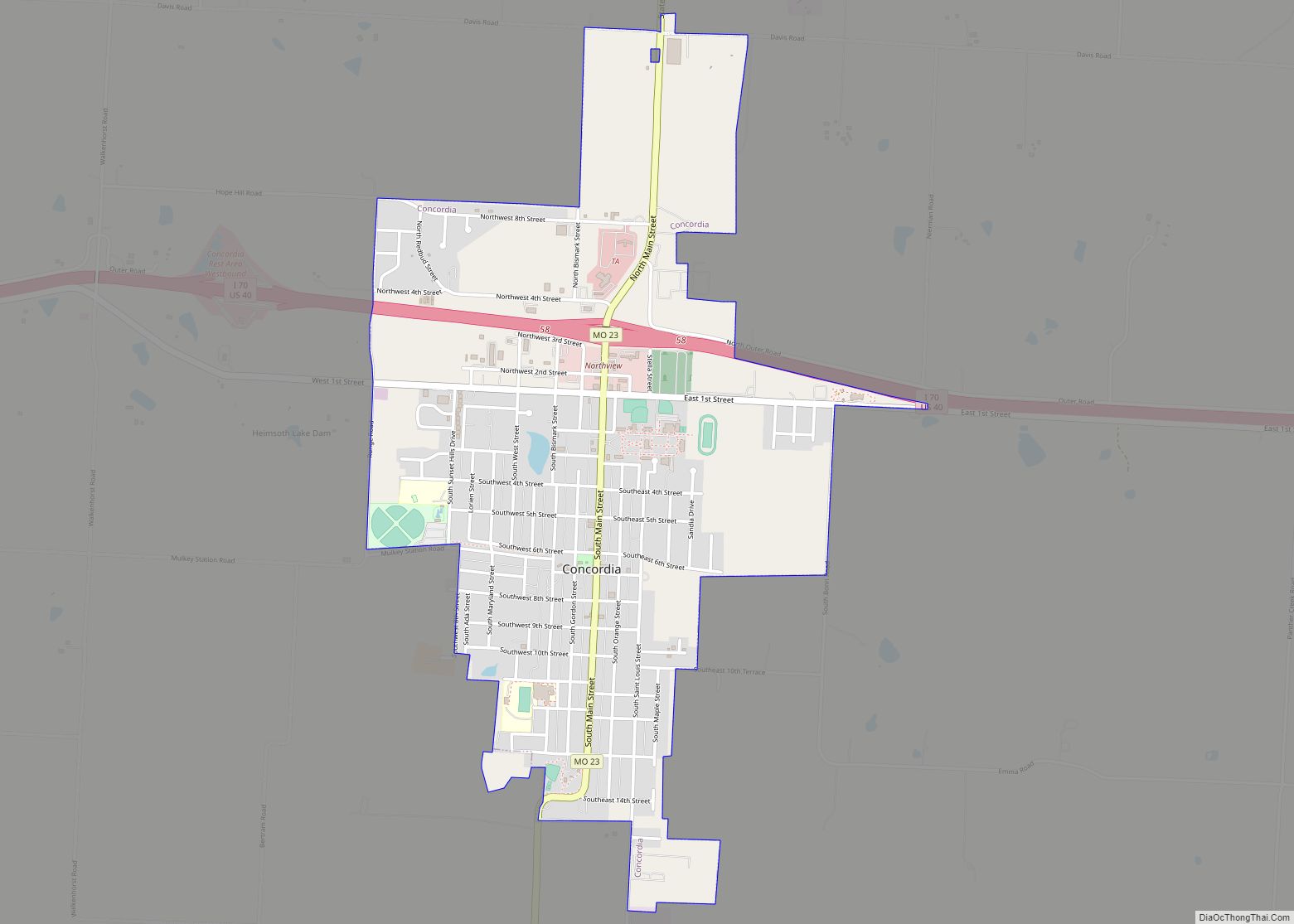
Concordia is a city in Lafayette County, Missouri, and is part of the Kansas City metropolitan area within the United States. The population was 2,450 at the 2010 census. Concordia city overview: Name: Concordia city LSAD Code: 25 LSAD Description: city (suffix) State: Missouri County: Lafayette County Elevation: 781 ft (238 m) Total Area: 1.84 sq mi (4.76 km²) Land … Read more

Map of Concord CDP, Missouri

Map of Concord CDP, Missouri

Concord is a census-designated place (CDP) in St. Louis County, Missouri, United States. The population was 16,421 at the 2010 census. It should not be confused with Concord Township; which the CDP shares much land with, but these areas’ boundaries are not identical. Concord CDP overview: Name: Concord CDP LSAD Code: 57 LSAD Description: CDP … Read more

Map of Cooter city

Map of Cooter city

Cooter is a city in Pemiscot County, Missouri, United States. The population was 343 at the 2020 census. Cooter city overview: Name: Cooter city LSAD Code: 25 LSAD Description: city (suffix) State: Missouri County: Pemiscot County Elevation: 262 ft (80 m) Total Area: 0.29 sq mi (0.76 km²) Land Area: 0.29 sq mi (0.76 km²) Water Area: 0.00 sq mi (0.00 km²) Total Population: 343 Population … Read more

Map of Cool Valley city

Map of Cool Valley city

Cool Valley is a city in St. Louis County, Missouri, United States in Greater St. Louis. The population was 1,196 at the 2010 census. Cool Valley city overview: Name: Cool Valley city LSAD Code: 25 LSAD Description: city (suffix) State: Missouri County: St. Louis County Elevation: 525 ft (160 m) Total Area: 0.46 sq mi (1.19 km²) Land Area: 0.46 sq mi … Read more

Map of Conway city, Missouri

Map of Conway city, Missouri

Conway is a city in Laclede County, Missouri, United States. The population was 788 at the 2010 census. Conway is located 15 miles (24 km) southwest of Lebanon. Conway city overview: Name: Conway city LSAD Code: 25 LSAD Description: city (suffix) State: Missouri County: Laclede County Elevation: 1,342 ft (409 m) Total Area: 1.83 sq mi (4.75 km²) Land Area: 1.82 sq mi … Read more

Map of Cosby village

Map of Cosby village

Cosby is a village in Andrew County, Missouri, United States. The population was 124 at the 2010 census. It is part of the St. Joseph, MO–KS Metropolitan Statistical Area. Cosby village overview: Name: Cosby village LSAD Code: 47 LSAD Description: village (suffix) State: Missouri County: Andrew County Elevation: 929 ft (283 m) Total Area: 0.09 sq mi (0.24 km²) Land … Read more

Map of Corning town, Missouri

Map of Corning town, Missouri

Corning is a village in Holt County, Missouri, United States. The population was 3 at the 2020 census. The village is named for Erastus Corning who owned sizeable shares of the Chicago, Burlington, and Quincy Railroad and who is the namesake of another Burlington railroad community Corning, Iowa. Corning town overview: Name: Corning town LSAD … Read more

Map of Corder city

Map of Corder city

Corder is a city in Lafayette County, Missouri, and is part of the Kansas City metropolitan area within the United States. The population was 404 at the 2010 census. Corder city overview: Name: Corder city LSAD Code: 25 LSAD Description: city (suffix) State: Missouri County: Lafayette County Elevation: 869 ft (265 m) Total Area: 0.36 sq mi (0.92 km²) Land … Read more

Map of Cottleville city

Map of Cottleville city

Cottleville is a city in St. Charles County, Missouri, United States. The population was 3,075 at the 2010 census. Cottleville city overview: Name: Cottleville city LSAD Code: 25 LSAD Description: city (suffix) State: Missouri County: St. Charles County Elevation: 495 ft (151 m) Total Area: 4.74 sq mi (12.27 km²) Land Area: 4.74 sq mi (12.27 km²) Water Area: 0.00 sq mi (0.00 km²) Total Population: … Read more

Map of Country Club village, Missouri

Map of Country Club village, Missouri

Country Club is a village in Andrew County, Missouri, United States. The population was 2,449 at the 2010 census. It is part of the St. Joseph, MO–KS Metropolitan Statistical Area. Country Club village overview: Name: Country Club village LSAD Code: 47 LSAD Description: village (suffix) State: Missouri County: Andrew County Elevation: 1,037 ft (316 m) Total Area: … Read more

Map of Country Club Hills city, Missouri

Map of Country Club Hills city, Missouri

Country Club Hills is a city in St. Louis County, Missouri, United States. The population was 1,274 at the 2010 census. Country Club Hills city overview: Name: Country Club Hills city LSAD Code: 25 LSAD Description: city (suffix) State: Missouri County: St. Louis County Elevation: 538 ft (164 m) Total Area: 0.19 sq mi (0.48 km²) Land Area: 0.19 sq mi (0.48 km²) … Read more

Map of Craig city, Missouri

Map of Craig city, Missouri

Craig is a city in Holt County, Missouri, United States. The population was 105 at the 2020 census. Craig city overview: Name: Craig city LSAD Code: 25 LSAD Description: city (suffix) State: Missouri County: Holt County Elevation: 869 ft (265 m) Total Area: 0.26 sq mi (0.67 km²) Land Area: 0.26 sq mi (0.67 km²) Water Area: 0.00 sq mi (0.00 km²) Total Population: 105 Population … Read more