Map of Dutchtown CDP

Map of Dutchtown CDP

Dutchtown is a census-designated place (CDP) and former village in Cape Girardeau County, Missouri, United States, located at the intersection of Routes 25 and 74. The population was 163 at the 2020 census. It was part of the Cape Girardeau–Jackson, MO-IL Metropolitan Statistical Area. Dutchtown CDP overview: Name: Dutchtown CDP LSAD Code: 57 LSAD Description: … Read more

Map of Eagleville town, Missouri

Map of Eagleville town, Missouri

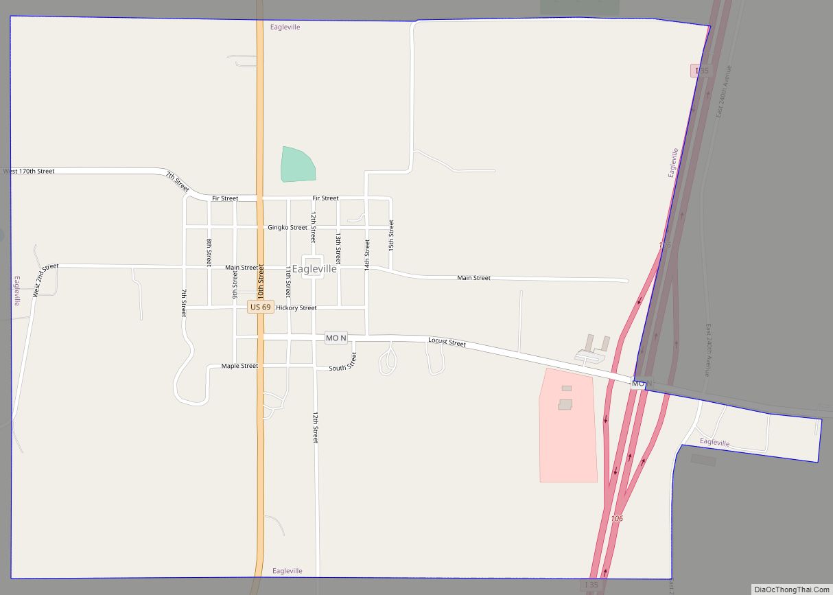
Eagleville is a village in northern Harrison County, Missouri, United States. The population was 275 at the 2020 census. Eagleville town overview: Name: Eagleville town LSAD Code: 43 LSAD Description: town (suffix) State: Missouri County: Harrison County Elevation: 1,096 ft (334 m) Total Area: 1.02 sq mi (2.64 km²) Land Area: 1.01 sq mi (2.62 km²) Water Area: 0.01 sq mi (0.02 km²) Total Population: 275 … Read more

Map of Easton city, Missouri

Map of Easton city, Missouri

Easton is a city in Buchanan County, Missouri, United States. The population was 234 at the 2010 census. It is part of the St. Joseph, MO–KS Metropolitan Statistical Area. Easton city overview: Name: Easton city LSAD Code: 25 LSAD Description: city (suffix) State: Missouri County: Buchanan County Elevation: 938 ft (286 m) Total Area: 0.59 sq mi (1.53 km²) Land … Read more

Map of East Prairie city

Map of East Prairie city

East Prairie is a city in Mississippi County, Missouri, United States. The population was 2,943 at the 2020 census. East Prairie city overview: Name: East Prairie city LSAD Code: 25 LSAD Description: city (suffix) State: Missouri County: Mississippi County Elevation: 308 ft (94 m) Total Area: 1.25 sq mi (3.24 km²) Land Area: 1.25 sq mi (3.24 km²) Water Area: 0.00 sq mi (0.00 km²) Total … Read more

Map of East Lynne city

Map of East Lynne city

East Lynne is a city in eastern Cass County, Missouri The population was 303 at the 2010 census. It is part of the Kansas City metropolitan area within the United States. East Lynne city overview: Name: East Lynne city LSAD Code: 25 LSAD Description: city (suffix) State: Missouri County: Cass County Elevation: 860 ft (260 m) Total … Read more

Map of Edina city, Missouri

Map of Edina city, Missouri

Edina is a city in Knox County, Missouri, United States, between the North and South Forks of the South Fabius River. As of the 2020 census, its population was 1,012. It is the county seat of Knox County. Edina city overview: Name: Edina city LSAD Code: 25 LSAD Description: city (suffix) State: Missouri County: Knox … Read more

Map of Edgerton city, Missouri

Map of Edgerton city, Missouri

Edgerton is a city in northeastern Platte County, Missouri and is part of the Kansas City metropolitan area within the United States. The population was 546 at the 2010 census. Edgerton city overview: Name: Edgerton city LSAD Code: 25 LSAD Description: city (suffix) State: Missouri County: Platte County Elevation: 840 ft (260 m) Total Area: 1.13 sq mi (2.92 km²) … Read more

Map of Edgar Springs city

Map of Edgar Springs city

Edgar Springs is a city in Phelps County, Missouri, United States. The population was 208 at the 2010 census. Edgar Springs city overview: Name: Edgar Springs city LSAD Code: 25 LSAD Description: city (suffix) State: Missouri County: Phelps County Elevation: 1,211 ft (369 m) Total Area: 0.47 sq mi (1.22 km²) Land Area: 0.47 sq mi (1.21 km²) Water Area: 0.00 sq mi (0.00 km²) Total … Read more

Map of El Dorado Springs city

Map of El Dorado Springs city

El Dorado Springs is the largest city in Cedar County, Missouri, United States. The population was 3,493 at the 2020 census. El Dorado Springs city overview: Name: El Dorado Springs city LSAD Code: 25 LSAD Description: city (suffix) State: Missouri County: Cedar County Elevation: 902 ft (275 m) Total Area: 3.10 sq mi (8.02 km²) Land Area: 3.08 sq mi (7.98 km²) Water … Read more

Map of Edmundson city

Map of Edmundson city

Edmundson is a city in St. Louis County, Missouri, United States. The population was estimated to be 860 at the time of the 2020 census. Edmundson city overview: Name: Edmundson city LSAD Code: 25 LSAD Description: city (suffix) State: Missouri County: St. Louis County Elevation: 591 ft (180 m) Total Area: 0.27 sq mi (0.71 km²) Land Area: 0.27 sq mi (0.71 km²) … Read more

Map of Edinburg CDP, Missouri

Map of Edinburg CDP, Missouri

Edinburg (also Edinburgh) is an unincorporated community and census-designated place (CDP) in Grundy County, Missouri, United States, 5 miles (8 km) west of Trenton. As of the 2020 census, Edinburg had a population of 84. Edinburg CDP overview: Name: Edinburg CDP LSAD Code: 57 LSAD Description: CDP (suffix) State: Missouri County: Grundy County Elevation: 955 ft (291 m) … Read more

Map of Ellisville city, Missouri

Map of Ellisville city, Missouri

Ellisville is a city in St. Louis County, Missouri, United States within Greater St. Louis. It is a western outer-ring suburb of St. Louis. The population was 9,985 at the 2020 census. In 2009, Money magazine ranked Ellisville #25 on the annual Best Places to Live in America list. The city is also currently home … Read more