Map of Fremont CDP, Missouri

Map of Fremont CDP, Missouri

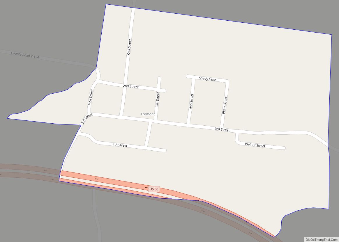
Fremont is a census-designated place in western Carter County, Missouri, United States. It is located on U.S. Route 60, approximately 10 miles (16 km) west of Van Buren in Pike Creek Valley. The community was founded circa 1887. As of the 2020 census it had a population of 43. Fremont CDP overview: Name: Fremont CDP LSAD … Read more

Map of Fremont Hills city

Map of Fremont Hills city

Fremont Hills is a city in Christian County, Missouri, United States. The population was 1,049 at the 2020 census. It is part of the Springfield, Missouri Metropolitan Statistical Area. Fremont Hills city overview: Name: Fremont Hills city LSAD Code: 25 LSAD Description: city (suffix) State: Missouri County: Christian County Elevation: 1,286 ft (392 m) Total Area: 0.55 sq mi … Read more

Map of Gainesville city, Missouri

Map of Gainesville city, Missouri

Gainesville is a city in Ozark County, Missouri, United States. The population was 745 at the 2020 census. It is the county seat of Ozark County. Gainesville city overview: Name: Gainesville city LSAD Code: 25 LSAD Description: city (suffix) State: Missouri County: Ozark County Elevation: 781 ft (238 m) Total Area: 2.87 sq mi (7.44 km²) Land Area: 2.87 sq mi (7.44 km²) … Read more

Map of Fulton city, Missouri

Map of Fulton city, Missouri

Fulton is the largest city in and the county seat of Callaway County, Missouri, United States. Located about 22 miles (35 km) northeast of Jefferson City and the Missouri River and 20 miles (32 km) east of Columbia, the city is part of the Jefferson City, Missouri, Metropolitan Statistical Area. The population was 12,790 in the 2010 … Read more

Map of Frontenac city, Missouri

Map of Frontenac city, Missouri

Frontenac is a city in St. Louis County, Missouri, United States. The population was 3,612 at the 2020 census. The community name is inspired by the New France governor Louis de Buade de Frontenac. Benjamin and Lora Wood, who laid out the community’s core called Frontenac Estates, that consisted of 26 two-acre estates, had made … Read more

Map of Galt city, Missouri

Map of Galt city, Missouri

Galt is a city in eastern Grundy County, Missouri, United States. The population was 168 at the 2020 census. Galt city overview: Name: Galt city LSAD Code: 25 LSAD Description: city (suffix) State: Missouri County: Grundy County Elevation: 827 ft (252 m) Total Area: 0.29 sq mi (0.74 km²) Land Area: 0.29 sq mi (0.74 km²) Water Area: 0.00 sq mi (0.00 km²) Total Population: 168 … Read more

Map of Gallatin city

Map of Gallatin city, Missouri

Gallatin is a city in Daviess County, Missouri, United States. The population was 1,821 at the 2020 census. It is the county seat of Daviess County. Gallatin city overview: Name: Gallatin city LSAD Code: 25 LSAD Description: city (suffix) State: Missouri County: Daviess County Incorporated: 1856 Elevation: 915 ft (279 m) Total Area: 2.77 sq mi (7.16 km²) Land Area: … Read more

Map of Galena city, Missouri

Map of Galena city, Missouri

Galena is a city in Stone County, Missouri, United States. The population was 455 at the 2020 census. It is the county seat of Stone County. Galena is part of the Branson, Missouri Micropolitan Statistical Area. Galena city overview: Name: Galena city LSAD Code: 25 LSAD Description: city (suffix) State: Missouri County: Stone County Elevation: … Read more

Map of Gentry village, Missouri

Map of Gentry village, Missouri

Gentry is a village in Gentry County, Missouri, United States. The population was 56 at the 2020 census. Gentry village overview: Name: Gentry village LSAD Code: 47 LSAD Description: village (suffix) State: Missouri County: Gentry County Elevation: 902 ft (275 m) Total Area: 0.23 sq mi (0.60 km²) Land Area: 0.23 sq mi (0.60 km²) Water Area: 0.00 sq mi (0.00 km²) Total Population: 56 Population … Read more

Map of Gasconade city

Map of Gasconade city

Gasconade is a city in Gasconade County, Missouri. The population is 172 as of the 2020 census. Gasconade city overview: Name: Gasconade city LSAD Code: 25 LSAD Description: city (suffix) State: Missouri County: Gasconade County Elevation: 528 ft (161 m) Total Area: 0.20 sq mi (0.53 km²) Land Area: 0.20 sq mi (0.53 km²) Water Area: 0.00 sq mi (0.00 km²) Total Population: 172 Population Density: … Read more

Map of Garden City, Missouri

Map of Garden City, Missouri

Garden City is a city in southeast Cass County, Missouri, United States. The population was 1,642 at the 2010 census. The city lies within the Kansas City metropolitan area. Garden City overview: Name: Garden City LSAD Code: 25 LSAD Description: city (suffix) State: Missouri County: Cass County Elevation: 919 ft (280 m) Total Area: 2.51 sq mi (6.50 km²) Land … Read more

Map of Gerster town

Map of Gerster town

Gerster is a town in St. Clair County, Missouri, United States. The population was 21 at the 2020 census. Gerster town overview: Name: Gerster town LSAD Code: 43 LSAD Description: town (suffix) State: Missouri County: St. Clair County Elevation: 807 ft (246 m) Total Area: 0.08 sq mi (0.21 km²) Land Area: 0.08 sq mi (0.21 km²) Water Area: 0.00 sq mi (0.00 km²) Total Population: … Read more