Map of Hollister city, Missouri

Map of Hollister city, Missouri

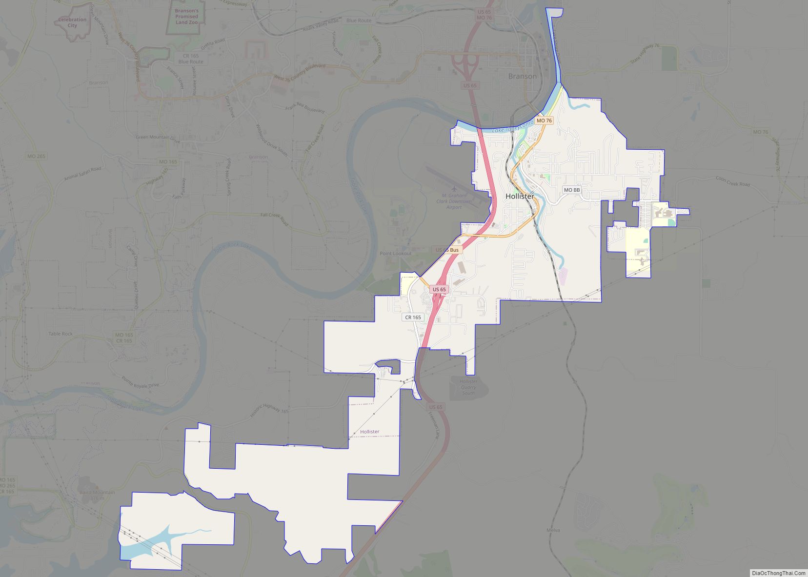
Hollister is a city in Taney County, Missouri, United States. The population was 4,583 at the 2020 census. Hollister city overview: Name: Hollister city LSAD Code: 25 LSAD Description: city (suffix) State: Missouri County: Taney County Elevation: 728 ft (222 m) Total Area: 6.37 sq mi (16.49 km²) Land Area: 6.33 sq mi (16.41 km²) Water Area: 0.03 sq mi (0.08 km²) Total Population: 4,583 Population … Read more

Map of Holliday village

Map of Holliday village, Missouri

Holliday is a village in Monroe County, Missouri, United States. The population was 114 at the 2020 census. Holliday village overview: Name: Holliday village LSAD Code: 47 LSAD Description: village (suffix) State: Missouri County: Monroe County Elevation: 784 ft (239 m) Total Area: 0.26 sq mi (0.68 km²) Land Area: 0.26 sq mi (0.68 km²) Water Area: 0.00 sq mi (0.00 km²) Total Population: 114 Population … Read more

Map of Homestead village, Missouri

Map of Homestead village, Missouri

Homestead village overview: Name: Homestead village LSAD Code: 47 LSAD Description: village (suffix) State: Missouri County: Ray County FIPS code: 2932806 Online Interactive Map Homestead online map. Source: Basemap layers from Google Map, Open Street Map (OSM), Arcgisonline, Wmflabs. Boundary Data from Database of Global Administrative Areas. Homestead location map. Where is Homestead village? Homestead … Read more

Map of Holts Summit city

Map of Holts Summit city

Holts Summit is a small city in Callaway County, Missouri. The population was 3,247 at the time of the 2010 census. Holts Summit is located 7 miles (11 km) northeast of Jefferson City, Missouri’s state capital. It is part of the Jefferson City Metropolitan Area. Holts Summit city overview: Name: Holts Summit city LSAD Code: 25 … Read more

Map of Homestown city

Map of Homestown city

Homestown is a city in Pemiscot County, Missouri, United States. The population was 73 at the 2020 census. Homestown city overview: Name: Homestown city LSAD Code: 25 LSAD Description: city (suffix) State: Missouri County: Pemiscot County Elevation: 269 ft (82 m) Total Area: 0.12 sq mi (0.32 km²) Land Area: 0.12 sq mi (0.32 km²) Water Area: 0.00 sq mi (0.00 km²) Total Population: 73 Population … Read more

Map of Hornersville city

Map of Hornersville city

Hornersville is a city in Dunklin County, Missouri, United States, founded in 1840. The population was 537 at the 2020 census. Hornersville city overview: Name: Hornersville city LSAD Code: 25 LSAD Description: city (suffix) State: Missouri County: Dunklin County Elevation: 246 ft (75 m) Total Area: 0.78 sq mi (2.03 km²) Land Area: 0.78 sq mi (2.02 km²) Water Area: 0.00 sq mi (0.01 km²) Total … Read more

Map of Horine CDP

Map of Horine CDP

Horine is an unincorporated community and census-designated place (CDP) in Jefferson County, Missouri, United States. The population was 821 at the 2010 census, down from 923 in 2000. Horine CDP overview: Name: Horine CDP LSAD Code: 57 LSAD Description: CDP (suffix) State: Missouri County: Jefferson County Elevation: 502 ft (153 m) Total Area: 0.72 sq mi (1.86 km²) Land Area: … Read more

Map of Hopkins city, Missouri

Map of Hopkins city, Missouri

Hopkins is a city in northern Nodaway County, Missouri, United States. The population was 532 at the 2010 Census. Hopkins city overview: Name: Hopkins city LSAD Code: 25 LSAD Description: city (suffix) State: Missouri County: Nodaway County Elevation: 1,053 ft (321 m) Total Area: 0.71 sq mi (1.85 km²) Land Area: 0.71 sq mi (1.85 km²) Water Area: 0.00 sq mi (0.00 km²) Total Population: 472 … Read more

Map of Houstonia city

Map of Houstonia city

Houstonia is a city in northwest Pettis County, Missouri, United States. The population was 220 at the 2010 census. Houstonia city overview: Name: Houstonia city LSAD Code: 25 LSAD Description: city (suffix) State: Missouri County: Pettis County Elevation: 771 ft (235 m) Total Area: 0.20 sq mi (0.51 km²) Land Area: 0.20 sq mi (0.51 km²) Water Area: 0.00 sq mi (0.00 km²) Total Population: 198 … Read more

Map of Houston city, Missouri

Map of Houston city, Missouri

Houston is a city in Texas County, Missouri, United States. The population was 2,079 at the 2020 census. It is the county seat of Texas County. Houston city overview: Name: Houston city LSAD Code: 25 LSAD Description: city (suffix) State: Missouri County: Texas County Elevation: 1,201 ft (366 m) Total Area: 3.65 sq mi (9.44 km²) Land Area: 3.64 sq mi (9.43 km²) … Read more

Map of Houston Lake city

Map of Houston Lake city

Houston Lake is a city in Platte County, Missouri, and is part of the Kansas City metropolitan area within the United States. The population was 235 at the 2010 census. Houston Lake city overview: Name: Houston Lake city LSAD Code: 25 LSAD Description: city (suffix) State: Missouri County: Platte County Elevation: 817 ft (249 m) Total Area: … Read more

Map of Humansville city

Map of Humansville city

Humansville is a city in Polk County, Missouri, United States. As of the 2010 census, the city population was 1,048. It is part of the Springfield, Missouri Metropolitan Statistical Area. Carl Long is the current mayor, sworn in on October 7, 2019. Humansville city overview: Name: Humansville city LSAD Code: 25 LSAD Description: city (suffix) … Read more