Map of Kirbyville village

Map of Kirbyville village, Missouri

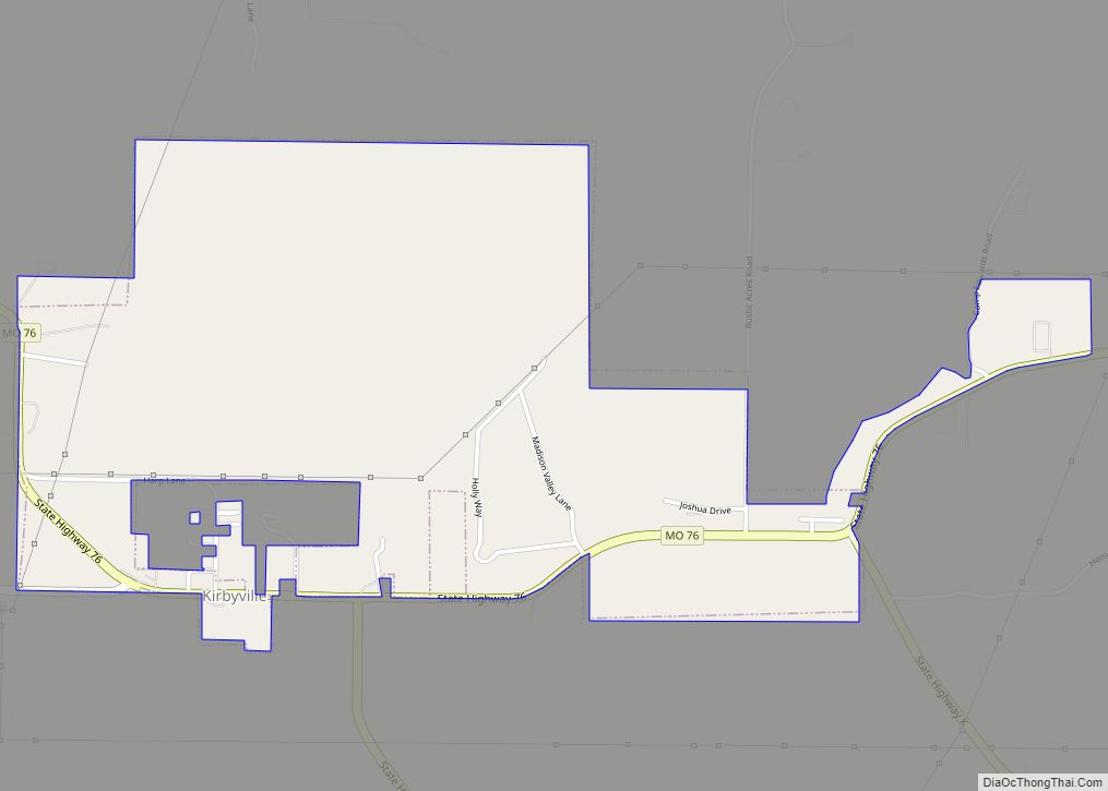
Kirbyville is a village in Taney County, Missouri, United States. The population was 195 at the 2020 census. It is part of the Branson, Missouri Micropolitan Statistical Area. Kirbyville village overview: Name: Kirbyville village LSAD Code: 47 LSAD Description: village (suffix) State: Missouri County: Taney County Incorporated: June 4, 2001 Elevation: 1,004 ft (306 m) Total Area: … Read more

Map of Kinloch city

Map of Kinloch city

Kinloch is a city in St. Louis County, Missouri, United States. The population was 298 as of the 2010 census. The oldest African-American community to be incorporated in Missouri, Kinloch was home to a vibrant and flourishing black community for much of the 19th and 20th century. It began to decline in the 1980s, when … Read more

Map of Knob Noster city

Map of Knob Noster city

Knob Noster /ˈnɒb ˈnɒstər/ is a city in Johnson County, Missouri, United States. The population was 2,709 at the 2010 census. It is located adjacent to and closely associated with Whiteman Air Force Base. Knob Noster State Park is nearby. Knob Noster city overview: Name: Knob Noster city LSAD Code: 25 LSAD Description: city (suffix) … Read more

Map of Kissee Mills CDP

Map of Kissee Mills CDP

Kissee Mills (pronounced “Kiz-zē’ Mills”) is a census-designated place in Taney County, Missouri, United States. It is located on U.S. Route 160, approximately five miles east of Forsyth. Kissee Mills is part of the Branson, Missouri Micropolitan Statistical Area. Kissee Mills CDP overview: Name: Kissee Mills CDP LSAD Code: 57 LSAD Description: CDP (suffix) State: … Read more

Map of Kirkwood city, Missouri

Map of Kirkwood city, Missouri

Kirkwood is an inner-ring western suburb of St. Louis located in St. Louis County, Missouri. As of the 2010 census, the city’s population was 27,540. Founded in 1853, the city is named after James P. Kirkwood, builder of the Pacific Railroad through that city. It was the first planned suburb located west of the Mississippi … Read more

Map of La Belle city

Map of La Belle city

La Belle is a city in western Lewis County, Missouri, United States. The population was 664 at the 2020 census. It is part of the Quincy, IL–MO Micropolitan Statistical Area. La Belle city overview: Name: La Belle city LSAD Code: 25 LSAD Description: city (suffix) State: Missouri County: Lewis County Elevation: 738 ft (225 m) Total Area: … Read more

Map of Koshkonong town

Map of Koshkonong town

Koshkonong is a city in Oregon County, Missouri, United States. The population was 196 at the 2020 census. Koshkonong town overview: Name: Koshkonong town LSAD Code: 43 LSAD Description: town (suffix) State: Missouri County: Oregon County Elevation: 961 ft (293 m) Total Area: 0.18 sq mi (0.46 km²) Land Area: 0.18 sq mi (0.46 km²) Water Area: 0.00 sq mi (0.00 km²) Total Population: 196 Population … Read more

Map of Knox City city

Map of Knox City, Missouri

Knox City is a city in eastern Knox County, Missouri, United States. As of the 2020 census, its population was 191. Knox City overview: Name: Knox City LSAD Code: 25 LSAD Description: city (suffix) State: Missouri County: Knox County Elevation: 764 ft (233 m) Total Area: 0.21 sq mi (0.55 km²) Land Area: 0.21 sq mi (0.55 km²) Water Area: 0.00 sq mi (0.00 km²) Total … Read more

Map of La Monte city

Map of La Monte city

La Monte is a city in Pettis County, Missouri, United States. The population was 1,140 at the 2010 census. La Monte city overview: Name: La Monte city LSAD Code: 25 LSAD Description: city (suffix) State: Missouri County: Pettis County Elevation: 846 ft (258 m) Total Area: 1.10 sq mi (2.84 km²) Land Area: 1.08 sq mi (2.81 km²) Water Area: 0.01 sq mi (0.03 km²) Total … Read more

Map of La Grange city, Missouri

Map of La Grange city, Missouri

La Grange is a city in Lewis County, Missouri, United States. The population was 825 at the 2020 census. Since the 1960 census, the population has been dwindling. It is part of the Quincy, IL–MO Micropolitan Statistical Area. La Grange city overview: Name: La Grange city LSAD Code: 25 LSAD Description: city (suffix) State: Missouri … Read more

Map of La Due village

Map of La Due village

La Due village overview: Name: La Due village LSAD Code: 47 LSAD Description: village (suffix) State: Missouri County: Henry County FIPS code: 2939638 Online Interactive Map La Due online map. Source: Basemap layers from Google Map, Open Street Map (OSM), Arcgisonline, Wmflabs. Boundary Data from Database of Global Administrative Areas. La Due location map. Where … Read more

Map of La Russell city

Map of La Russell city

La Russell is a city in Jasper County, Missouri, United States. The population was 134 at the 2020 census. It is part of the Joplin, Missouri Metropolitan Statistical Area. La Russell city overview: Name: La Russell city LSAD Code: 25 LSAD Description: city (suffix) State: Missouri County: Jasper County Elevation: 1,079 ft (329 m) Total Area: 0.34 sq mi … Read more