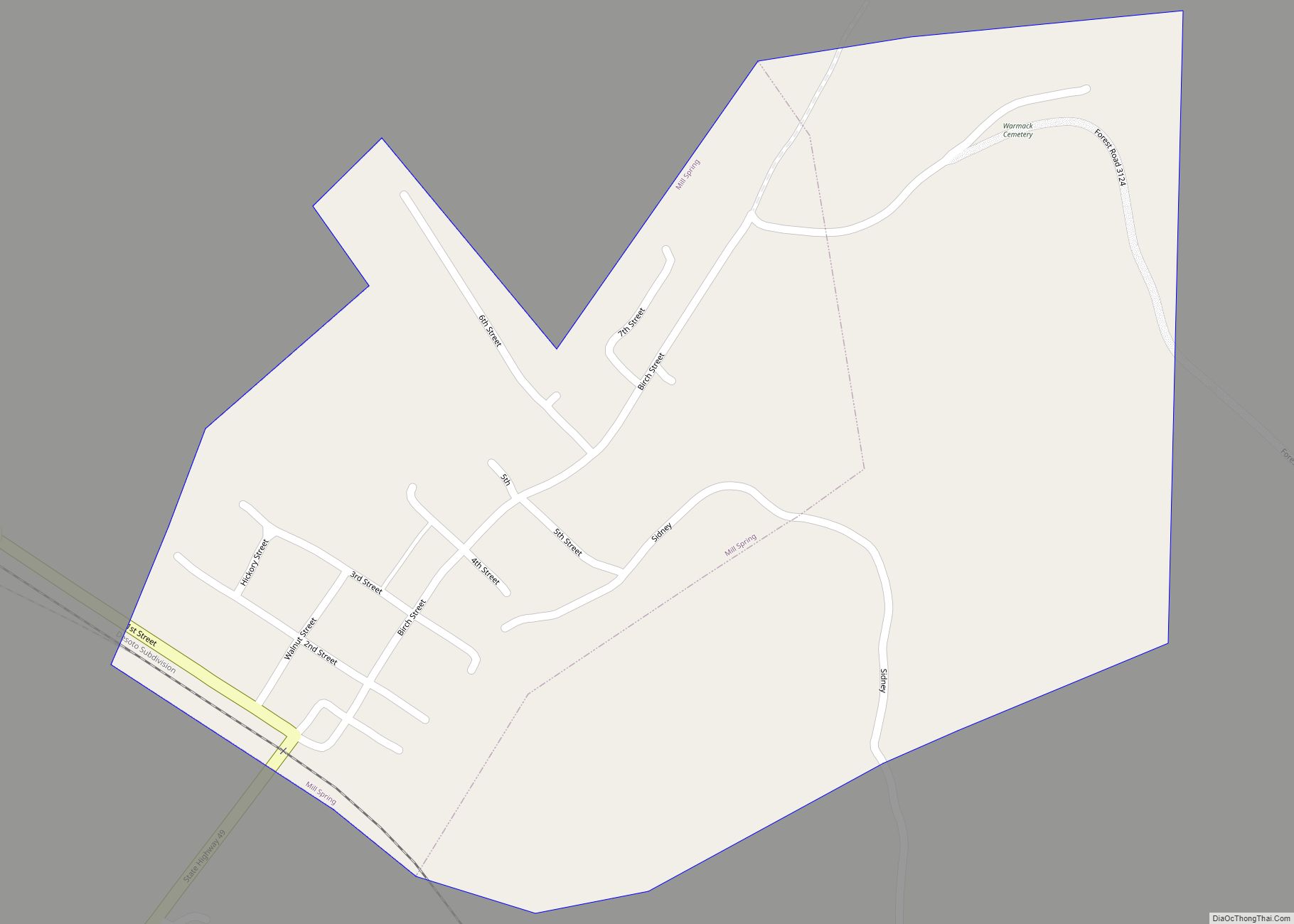
Map of Milford village, Missouri

Map of Milford village, Missouri

Milford is a village in Barton County, Missouri, United States. The population was 24 at the 2020 census. Milford village overview: Name: Milford village LSAD Code: 47 LSAD Description: village (suffix) State: Missouri County: Barton County Elevation: 922 ft (281 m) Total Area: 0.04 sq mi (0.11 km²) Land Area: 0.04 sq mi (0.11 km²) Water Area: 0.00 sq mi (0.00 km²) Total Population: 24 Population … Read more

Map of Millard village

Map of Millard village

Millard is a village in Pettis Township, Adair County, Missouri, United States. The population was 89 at the 2010 census. Millard village overview: Name: Millard village LSAD Code: 47 LSAD Description: village (suffix) State: Missouri County: Adair County Elevation: 968 ft (295 m) Total Area: 0.12 sq mi (0.31 km²) Land Area: 0.12 sq mi (0.31 km²) Water Area: 0.00 sq mi (0.00 km²) Total Population: … Read more

Map of Mindenmines city

Map of Mindenmines city

Mindenmines is a city in Barton County, Missouri, United States. The population was 271 at the 2020 census. The city lies approximately four miles east of Frontenac, Kansas. It has possessed a post office since 1883. It is also the home of the Bank of Minden. (named Tusconia 1883–1884, Minden Mines 1884–1895, and Mindenmines since … Read more

Map of Milo village, Missouri

Map of Milo village, Missouri

Milo is a village in Vernon County, Missouri, United States. The population was 90 at the 2010 census. Milo village overview: Name: Milo village LSAD Code: 47 LSAD Description: village (suffix) State: Missouri County: Vernon County Elevation: 876 ft (267 m) Total Area: 0.08 sq mi (0.20 km²) Land Area: 0.08 sq mi (0.20 km²) Water Area: 0.00 sq mi (0.00 km²) Total Population: 57 Population … Read more

Map of Miller city, Missouri

Map of Miller city, Missouri

Miller is a town in Lawrence County, Missouri, United States. As of the 2010 census, the city population was 699. Miller city overview: Name: Miller city LSAD Code: 25 LSAD Description: city (suffix) State: Missouri County: Lawrence County Elevation: 1,302 ft (397 m) Total Area: 0.77 sq mi (1.99 km²) Land Area: 0.77 sq mi (1.99 km²) Water Area: 0.00 sq mi (0.00 km²) Total Population: … Read more

Map of Mineral Point town

Map of Mineral Point town, Missouri

Mineral Point is a village in Washington County, Missouri, United States. The population was 351 at the 2010 census. Mineral Point town overview: Name: Mineral Point town LSAD Code: 43 LSAD Description: town (suffix) State: Missouri County: Washington County Incorporated: 1905 Elevation: 886 ft (270 m) Total Area: 0.24 sq mi (0.62 km²) Land Area: 0.24 sq mi (0.62 km²) Water Area: 0.00 sq mi … Read more

Map of Miner city

Map of Miner city

Miner is a city in Mississippi and Scott counties in the U.S. state of Missouri. It borders the city of Sikeston to the east. The population was 916 at the 2020 census. Miner city overview: Name: Miner city LSAD Code: 25 LSAD Description: city (suffix) State: Missouri County: Mississippi County, Scott County Elevation: 312 ft (95 m) … Read more

Map of Mine La Motte CDP

Map of Mine La Motte CDP

Mine La Motte is an unincorporated community and census-designated place in Madison County, Missouri, United States. It is located approximately six miles north of Fredericktown. Mine La Motte CDP overview: Name: Mine La Motte CDP LSAD Code: 57 LSAD Description: CDP (suffix) State: Missouri County: Madison County Elevation: 774 ft (236 m) Total Area: 3.37 sq mi (8.73 km²) Land … Read more

Map of Moberly city

Map of Moberly city

Moberly is a city in Randolph County, Missouri, United States. The population was 13,974 at the 2010 census. It is part of the Columbia, Missouri metropolitan area. Moberly city overview: Name: Moberly city LSAD Code: 25 LSAD Description: city (suffix) State: Missouri County: Randolph County Founded: 1866 Incorporated: 1868 Elevation: 873 ft (266 m) Total Area: 13.22 sq mi … Read more

Map of Missouri City city

Map of Missouri City, Missouri

Missouri City is a city in Clay County, Missouri, United States. The population was 217 at the 2020 census. It is part of the Kansas City metropolitan area. Missouri City overview: Name: Missouri City LSAD Code: 25 LSAD Description: city (suffix) State: Missouri County: Clay County Elevation: 892 ft (272 m) Total Area: 1.10 sq mi (2.84 km²) Land Area: … Read more

Map of Miramiguoa Park village

Map of Miramiguoa Park village

Miramiguoa Park is a village in Franklin County, Missouri, United States. The population was 120 at the 2010 census. Miramiguoa Park village overview: Name: Miramiguoa Park village LSAD Code: 47 LSAD Description: village (suffix) State: Missouri County: Franklin County Elevation: 643 ft (196 m) Total Area: 0.39 sq mi (1.00 km²) Land Area: 0.39 sq mi (1.00 km²) Water Area: 0.00 sq mi (0.00 km²) Total … Read more

Map of Monett city

Map of Monett city

Monett is the most-populous city in the Barry and Lawrence counties in the U.S. state of Missouri. The city is located in the Ozarks, just south of Interstate 44 between Joplin and Springfield. According to the 2020 census, the population of the town was estimated to be 9,576 individuals. Monett city overview: Name: Monett city … Read more