Map of Scott City, Missouri

Map of Scott City, Missouri

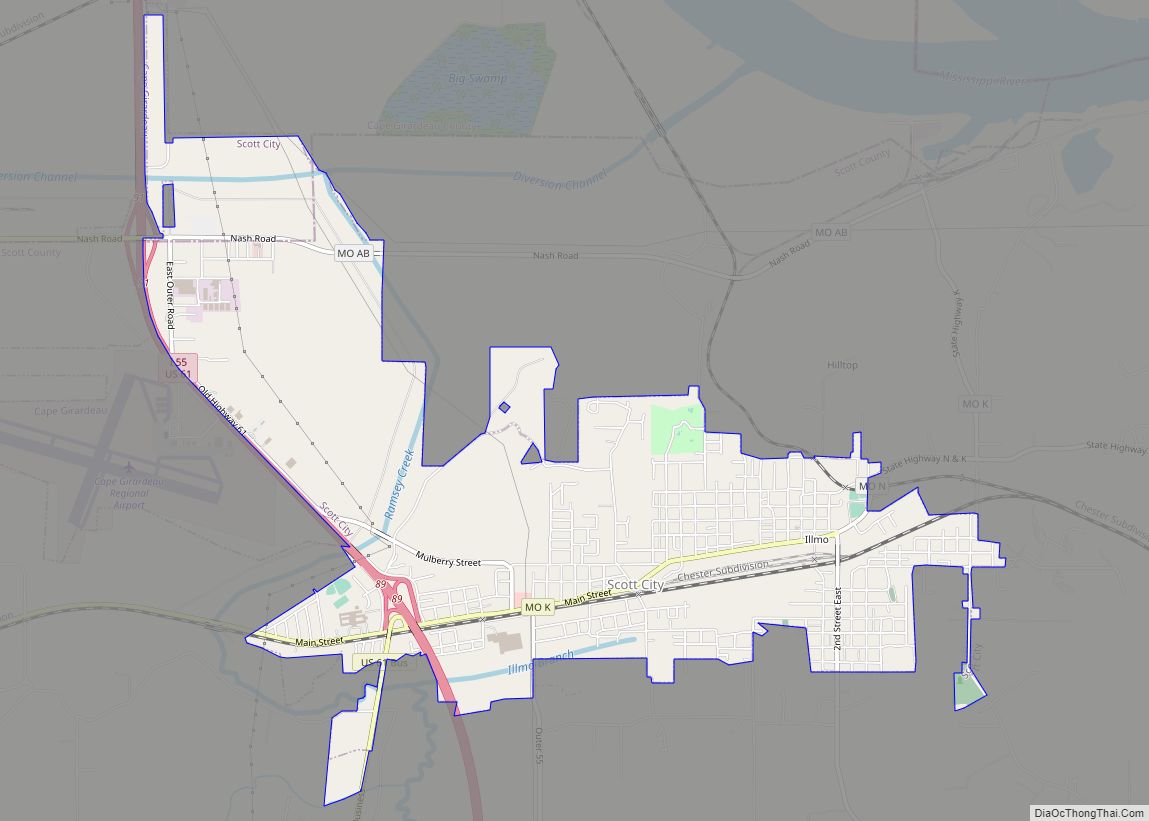
Scott City is a city in Cape Girardeau and Scott counties in the U.S. state of Missouri. The population was 4,346 at the 2020 census. The Scott County portion of Scott City (the majority) is part of the Sikeston Micropolitan Statistical Area, while the Cape Girardeau County portion is part of the Cape Girardeau–Jackson, MO-IL … Read more

Map of Scotsdale town

Map of Scotsdale town

Scotsdale town overview: Name: Scotsdale town LSAD Code: 43 LSAD Description: town (suffix) State: Missouri County: Jefferson County FIPS code: 2966337 Online Interactive Map Scotsdale online map. Source: Basemap layers from Google Map, Open Street Map (OSM), Arcgisonline, Wmflabs. Boundary Data from Database of Global Administrative Areas. Scotsdale location map. Where is Scotsdale town? Scotsdale … Read more

Map of Senath city

Map of Senath city

Senath /ˈsiːnəθ/ (SEE-nəth) is a city in Dunklin County, Missouri, United States. The population was 1,767 at the 2010 census. Senath city overview: Name: Senath city LSAD Code: 25 LSAD Description: city (suffix) State: Missouri County: Dunklin County Elevation: 256 ft (78 m) Total Area: 1.92 sq mi (4.98 km²) Land Area: 1.92 sq mi (4.98 km²) Water Area: 0.00 sq mi (0.00 km²) Total Population: … Read more

Map of Seligman city, Missouri

Map of Seligman city, Missouri

Seligman is a city in Sugar Creek Township, Barry County, Missouri, United States. The population was 851 at the 2010 census. The town is named after Joseph Seligman, a prominent 19th-century businessman. The name Seligman (זעליגמאן, זעליקמאן) is of Yiddish derivation and means “a jolly, cheerful person”. Seligman city overview: Name: Seligman city LSAD Code: … Read more

Map of Sedgewickville village

Map of Sedgewickville village

Sedgewickville is a village in northern Bollinger County in Southeast Missouri, United States. The population was 191 at the 2020 census. Sedgewickville is part of the Cape Girardeau–Jackson, MO-IL Metropolitan Statistical Area. Sedgewickville village overview: Name: Sedgewickville village LSAD Code: 47 LSAD Description: village (suffix) State: Missouri County: Bollinger County Incorporated: 1898 Elevation: 604 ft (184 m) … Read more

Map of Shelbina city

Map of Shelbina city

Shelbina /ʃɛlˈbaɪnə/ is a city in southern Shelby County, Missouri, United States. The population was 1,613 at the 2020 census. Shelbina city overview: Name: Shelbina city LSAD Code: 25 LSAD Description: city (suffix) State: Missouri County: Shelby County Elevation: 778 ft (237 m) Total Area: 2.34 sq mi (6.05 km²) Land Area: 2.34 sq mi (6.05 km²) Water Area: 0.00 sq mi (0.00 km²) Total Population: … Read more

Map of Seymour city, Missouri

Map of Seymour city, Missouri

Seymour is a city in southeastern Webster County, Missouri, United States. The population was 1,921 at the 2010 census. It is part of the Springfield, Missouri Metropolitan Statistical Area. Seymour city overview: Name: Seymour city LSAD Code: 25 LSAD Description: city (suffix) State: Missouri County: Webster County Elevation: 1,644 ft (501 m) Total Area: 3.48 sq mi (9.03 km²) Land … Read more

Map of Seneca city, Missouri

Map of Seneca city, Missouri

Seneca is a city in western Newton County, Missouri, United States. The population was 2,336 at the 2010 census. Located on the southwest border of the state, the city is part of the Joplin, Missouri Metropolitan Statistical Area. Seneca city overview: Name: Seneca city LSAD Code: 25 LSAD Description: city (suffix) State: Missouri County: Newton … Read more

Map of Shelbyville city, Missouri

Map of Shelbyville city, Missouri

Shelbyville is a city in Shelby County, Missouri, United States. The population was 518 at the 2020 census. It is the county seat of Shelby County. Shelbyville city overview: Name: Shelbyville city LSAD Code: 25 LSAD Description: city (suffix) State: Missouri County: Shelby County Elevation: 768 ft (234 m) Total Area: 0.82 sq mi (2.12 km²) Land Area: 0.78 sq mi (2.01 km²) … Read more

Map of Shell Knob CDP

Map of Shell Knob CDP

Shell Knob is a census-designated place (CDP) located within White River Township, Barry County, Missouri. The population was 1,254 at the 2020 census. The Stone County portion of Shell Knob is part of the Branson, Missouri Micropolitan Statistical Area. Shell Knob CDP overview: Name: Shell Knob CDP LSAD Code: 57 LSAD Description: CDP (suffix) State: … Read more

Map of Sheldon city, Missouri

Map of Sheldon city, Missouri

Sheldon is a city in southern Vernon County, Missouri, United States. The population was 543 at the 2010 census. Sheldon city overview: Name: Sheldon city LSAD Code: 25 LSAD Description: city (suffix) State: Missouri County: Vernon County Elevation: 912 ft (278 m) Total Area: 0.53 sq mi (1.36 km²) Land Area: 0.53 sq mi (1.36 km²) Water Area: 0.00 sq mi (0.00 km²) Total Population: 435 … Read more

Map of Shoal Creek Estates village

Map of Shoal Creek Estates village

Shoal Creek Estates is a village in Newton County, Missouri, United States. The population was 76 at the 2010 census. It is part of the Joplin, Missouri Metropolitan Statistical Area. Shoal Creek Estates village overview: Name: Shoal Creek Estates village LSAD Code: 47 LSAD Description: village (suffix) State: Missouri County: Newton County Elevation: 1,027 ft (313 m) … Read more