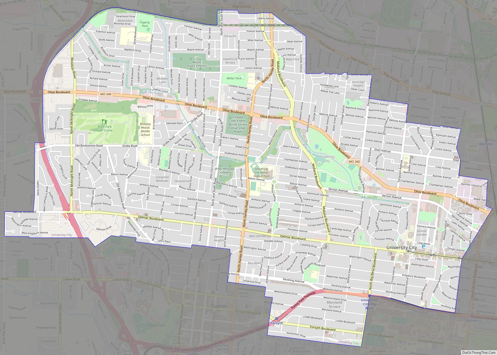
Map of Unity Village village

Map of Unity Village village

Unity Village is a village in Jackson County, Missouri, United States, bordering Kansas City and Lee’s Summit. It is part of the Kansas City metropolitan area. Its population was 99 at the 2010 census. The founders of the Unity spiritual movement, Charles and Myrtle Fillmore, purchased a 58-acre farm in 1919 as a weekend getaway … Read more

Map of Van Buren town, Missouri

Map of Van Buren town, Missouri

Van Buren is a city in Carter County, Missouri, United States. It is the county seat and largest city in Carter County. Van Buren was founded in 1833 as the county seat of Ripley County and was named after then Vice President of the United States, Martin Van Buren. In 1859, Van Buren became a … Read more

Map of Valley Park city

Map of Valley Park city, Missouri

Valley Park is a city in St. Louis County, Missouri, United States. The population was 6,885 at the 2020 census. Valley Park city overview: Name: Valley Park city LSAD Code: 25 LSAD Description: city (suffix) State: Missouri County: St. Louis County Elevation: 423 ft (129 m) Total Area: 5.09 sq mi (13.19 km²) Land Area: 4.50 sq mi (11.66 km²) Water Area: 0.59 sq mi … Read more

Map of Utica village, Missouri

Map of Utica village, Missouri

Utica is a village in Livingston County, Missouri, United States. The population was 222 at the 2020 census. Utica village overview: Name: Utica village LSAD Code: 47 LSAD Description: village (suffix) State: Missouri County: Livingston County Elevation: 761 ft (232 m) Total Area: 0.86 sq mi (2.22 km²) Land Area: 0.86 sq mi (2.22 km²) Water Area: 0.00 sq mi (0.00 km²) Total Population: 222 Population … Read more

Map of Vandiver village, Missouri

Map of Vandiver village, Missouri

Vandiver is a village in Audrain County, Missouri, United States. As of the 2010 census, the village population was 77. Vandiver village overview: Name: Vandiver village LSAD Code: 47 LSAD Description: village (suffix) State: Missouri County: Audrain County Elevation: 814 ft (248 m) Total Area: 0.32 sq mi (0.82 km²) Land Area: 0.31 sq mi (0.81 km²) Water Area: 0.00 sq mi (0.01 km²) Total Population: … Read more

Map of Vandalia city, Missouri

Map of Vandalia city, Missouri

Vandalia is a city in northeastern Audrain and extending into southeastern Ralls Counties in the U.S. state of Missouri. The population was 3,553 at the 2020 census, which includes about 1,000 prisoners incarcerated at the prison located within the city limits. The Audrain County portion of Vandalia is part of the Mexico Micropolitan Statistical Area, … Read more

Map of Versailles city, Missouri

Map of Versailles city, Missouri

Versailles is a city in Morgan County, Missouri, United States. The population was 2,482 at the 2010 census. It is the county seat of Morgan County. Locally, the town’s name is pronounced “Ver-sails”, rather than “Ver-seye,” as in the French pronunciation of the royal palace for which the town is named. Versailles city overview: Name: … Read more

Map of Verona town, Missouri

Map of Verona town, Missouri

Verona is a city in Lawrence County, Missouri, United States. The population was 619 at the 2010 census, later estimated to be 826 as of July 1, 2020. Verona town overview: Name: Verona town LSAD Code: 43 LSAD Description: town (suffix) State: Missouri County: Lawrence County Founded: 1857 Incorporated: 1916 Elevation: 1,280 ft (390 m) Total Area: … Read more

Map of Velda Village Hills city

Map of Velda Village Hills city

Velda Village Hills is a city in northeastern St. Louis County, Missouri, United States. The population was 1,055 at the 2010 census. Velda Village Hills city overview: Name: Velda Village Hills city LSAD Code: 25 LSAD Description: city (suffix) State: Missouri County: St. Louis County Elevation: 571 ft (174 m) Total Area: 0.12 sq mi (0.31 km²) Land Area: 0.12 sq mi … Read more

Map of Velda City city

Map of Velda City

Velda City is a city in St. Louis County, Missouri, United States. The population was 1,420 at the 2010 census. Velda City overview: Name: Velda City LSAD Code: 25 LSAD Description: city (suffix) State: Missouri County: St. Louis County Elevation: 607 ft (185 m) Total Area: 0.16 sq mi (0.42 km²) Land Area: 0.16 sq mi (0.42 km²) Water Area: 0.00 sq mi (0.00 km²) Total … Read more

Map of Vanduser village

Map of Vanduser village

Vanduser is a village in Scott County, Missouri, United States. The population was 267 at the 2010 census. The zip code is 63784. Vanduser village overview: Name: Vanduser village LSAD Code: 47 LSAD Description: village (suffix) State: Missouri County: Scott County Elevation: 312 ft (95 m) Total Area: 0.13 sq mi (0.33 km²) Land Area: 0.13 sq mi (0.33 km²) Water Area: 0.00 sq mi … Read more

Map of Vinita Park city

Map of Vinita Park city

Vinita Park is a city in St. Louis County, Missouri, United States, located just east of I-170 and south of St. Charles Rock Road. The population was 1,970 at the 2020 census. Vinita Park city overview: Name: Vinita Park city LSAD Code: 25 LSAD Description: city (suffix) State: Missouri County: St. Louis County Elevation: 594 ft … Read more