Map of West Sullivan town

Map of West Sullivan town

West Sullivan is a village on former U.S. Route 66 in northern Crawford County, Missouri, United States. The community was incorporated in 2000. The population was 119 at the 2010 census. West Sullivan town overview: Name: West Sullivan town LSAD Code: 43 LSAD Description: town (suffix) State: Missouri County: Crawford County Elevation: 974 ft (297 m) Total … Read more

Map of West Plains city

Map of West Plains city

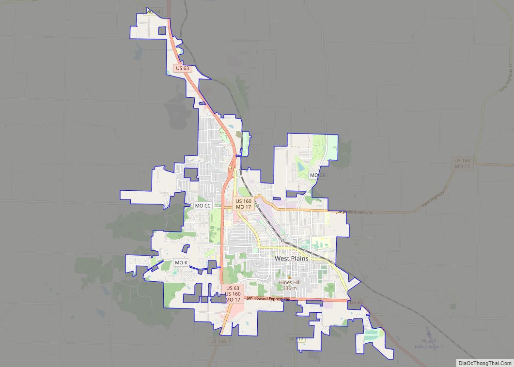
West Plains is a city in and the county seat of Howell County, Missouri, United States. The population was 12,184 at the 2020 census. West Plains city overview: Name: West Plains city LSAD Code: 25 LSAD Description: city (suffix) State: Missouri County: Howell County Elevation: 994 ft (303 m) Total Area: 13.33 sq mi (34.51 km²) Land Area: 13.30 sq mi (34.46 km²) … Read more

Map of West Line village

Map of West Line village

West Line is a village in Cass County, Missouri. The population was 97 at the 2010 census. It is part of the Kansas City metropolitan area. West Line village overview: Name: West Line village LSAD Code: 47 LSAD Description: village (suffix) State: Missouri County: Cass County Elevation: 902 ft (275 m) Total Area: 0.45 sq mi (1.18 km²) Land Area: … Read more

Map of Wheaton city, Missouri

Map of Wheaton city, Missouri

Wheaton is a city in Wheaton Township, Barry County, Missouri, United States. The population was 696 at the 2010 census. Wheaton city overview: Name: Wheaton city LSAD Code: 25 LSAD Description: city (suffix) State: Missouri County: Barry County Elevation: 1,371 ft (418 m) Total Area: 0.51 sq mi (1.32 km²) Land Area: 0.51 sq mi (1.32 km²) Water Area: 0.00 sq mi (0.00 km²) Total Population: … Read more

Map of Wheatland city, Missouri

Map of Wheatland city, Missouri

Wheatland is a city in Hickory County, Missouri, United States. The population was 277 at the 2020 census. Wheatland city overview: Name: Wheatland city LSAD Code: 25 LSAD Description: city (suffix) State: Missouri County: Hickory County Elevation: 1,089 ft (332 m) Total Area: 1.17 sq mi (3.03 km²) Land Area: 1.17 sq mi (3.02 km²) Water Area: 0.00 sq mi (0.00 km²) Total Population: 277 Population … Read more

Map of Westwood village, Missouri

Map of Westwood village, Missouri

Westwood is a village in west St. Louis County, Missouri, United States. The population was 316 at the 2020 census. Westwood village overview: Name: Westwood village LSAD Code: 47 LSAD Description: village (suffix) State: Missouri County: St. Louis County Elevation: 587 ft (179 m) Total Area: 0.63 sq mi (1.63 km²) Land Area: 0.63 sq mi (1.63 km²) Water Area: 0.00 sq mi (0.00 km²) Total … Read more

Map of Westphalia city, Missouri

Map of Westphalia city, Missouri

Westphalia is a city in Osage County, Missouri, United States. The population was 378 at the 2020 census. It is part of the Jefferson City, Missouri Metropolitan Statistical Area. Westphalia is heavily influenced by the German heritage of the majority of its inhabitants. Many of the early settlers of the area came from the Westphalia … Read more

Map of Weston city, Missouri

Map of Weston city, Missouri

Weston is a town in Platte County, Missouri within the United States. The population was 1,641 at the 2010 census. Weston city overview: Name: Weston city LSAD Code: 25 LSAD Description: city (suffix) State: Missouri County: Platte County Elevation: 971 ft (296 m) Total Area: 3.83 sq mi (9.93 km²) Land Area: 3.80 sq mi (9.83 km²) Water Area: 0.04 sq mi (0.10 km²) Total Population: … Read more

Map of Wilbur Park village

Map of Wilbur Park village

Wilbur Park is a village in St. Louis County, Missouri, United States. The population was 439 at the 2020 census. Wilbur Park village overview: Name: Wilbur Park village LSAD Code: 47 LSAD Description: village (suffix) State: Missouri County: St. Louis County Elevation: 509 ft (155 m) Total Area: 0.06 sq mi (0.15 km²) Land Area: 0.06 sq mi (0.15 km²) Water Area: 0.00 sq mi … Read more

Map of Whitewater town, Missouri

Map of Whitewater town, Missouri

Whitewater is a village in Hubble Township in southwestern Cape Girardeau County, Missouri, United States. The population was 88 at the 2020 census. It is part of the Cape Girardeau–Jackson, MO-IL Metropolitan Statistical Area. Whitewater town overview: Name: Whitewater town LSAD Code: 43 LSAD Description: town (suffix) State: Missouri County: Cape Girardeau County Elevation: 374 ft … Read more

Map of Whiteside village

Map of Whiteside village

Whiteside is a village in Union Township in Lincoln County, Missouri, United States. The population was 75 at the 2010 census. Whiteside village overview: Name: Whiteside village LSAD Code: 47 LSAD Description: village (suffix) State: Missouri County: Lincoln County Elevation: 801 ft (244 m) Total Area: 0.10 sq mi (0.27 km²) Land Area: 0.10 sq mi (0.27 km²) Water Area: 0.00 sq mi (0.00 km²) Total … Read more

Map of Whiteman AFB CDP

Map of Whiteman AFB CDP

Whiteman Air Force Base is a United States Air Force base located just south of Knob Noster, Missouri, United States. The base is the current home of the B-2 Spirit bomber. It is named for 2nd Lt George Whiteman, who was killed during the attack on Pearl Harbor. Whiteman AFB CDP overview: Name: Whiteman AFB … Read more