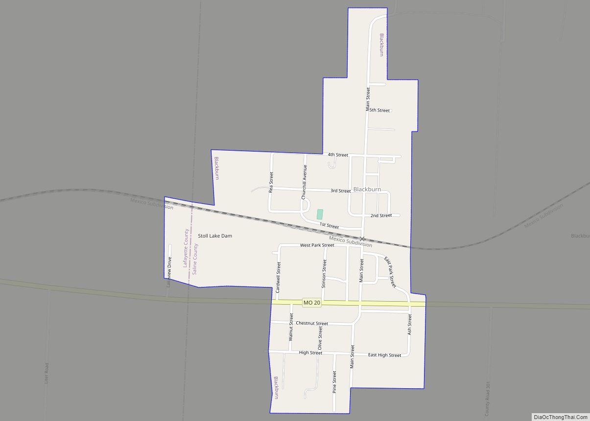
Map of Blairstown city, Missouri

Map of Blairstown city, Missouri

Blairstown is a city in Henry County, Missouri, United States. The population was 97 at the 2010 census. Blairstown city overview: Name: Blairstown city LSAD Code: 25 LSAD Description: city (suffix) State: Missouri County: Henry County Elevation: 784 ft (239 m) Total Area: 0.25 sq mi (0.64 km²) Land Area: 0.25 sq mi (0.64 km²) Water Area: 0.00 sq mi (0.00 km²) Total Population: 95 Population … Read more

Map of Blackwater city, Missouri

Map of Blackwater city, Missouri

Blackwater is a city in northwest Cooper County, Missouri, United States located along the Blackwater River, from which it takes its name. The population was 162 at the 2010 census. Many parts of Blackwater’s commercial and residential districts are listed on the National Register of Historic Places. Blackwater city overview: Name: Blackwater city LSAD Code: … Read more

Map of Blodgett village

Map of Blodgett village, Missouri

Blodgett is a village in Scott County, Missouri, United States. The population was 213 at the 2010 census. Blodgett village overview: Name: Blodgett village LSAD Code: 47 LSAD Description: village (suffix) State: Missouri County: Scott County Elevation: 325 ft (99 m) Total Area: 0.13 sq mi (0.34 km²) Land Area: 0.13 sq mi (0.34 km²) Water Area: 0.00 sq mi (0.00 km²) Total Population: 209 Population … Read more

Map of Bland city

Map of Bland city, Missouri

Bland is a city in Gasconade and Osage counties in the U.S. state of Missouri. The population was 506 at the 2020 census. The Osage County portion of Bland is part of the Jefferson City, Missouri Metropolitan Statistical Area. Bland city overview: Name: Bland city LSAD Code: 25 LSAD Description: city (suffix) State: Missouri County: … Read more

Map of Blanchard CDP, Missouri

Map of Blanchard CDP, Missouri

Blanchard is a census-designated place and unincorporated community in Atchison County, Missouri, United States. As of the 2020 census, its population was 27. The community is located on the Iowa border and is adjacent to the city of Blanchard, Iowa. It has sometimes been known as “South Blanchard”. Blanchard CDP overview: Name: Blanchard CDP LSAD … Read more

Map of Blue Eye town, Missouri

Map of Blue Eye town, Missouri

Blue Eye is an incorporated village in Stone County, Missouri, United States. The population was 289 at the 2020 census. The population estimate is 390 as of 2021. It is part of the Branson Micropolitan Statistical Area. Blue Eye, Missouri is adjacent to Blue Eye, Arkansas. Blue Eye town overview: Name: Blue Eye town LSAD … Read more

Map of Bloomsdale city

Map of Bloomsdale city

Bloomsdale is a city in Ste. Genevieve County, Missouri, United States. The population was 639 at the 2020 census. Bloomsdale city overview: Name: Bloomsdale city LSAD Code: 25 LSAD Description: city (suffix) State: Missouri County: Ste. Genevieve County Elevation: 518 ft (158 m) Total Area: 1.64 sq mi (4.24 km²) Land Area: 1.63 sq mi (4.22 km²) Water Area: 0.01 sq mi (0.02 km²) Total Population: … Read more

Map of Bloomfield city, Missouri

Map of Bloomfield city, Missouri

Bloomfield is a city in Stoddard County, Missouri, United States. The population was 1,933 at the 2010 census. It is the county seat of Stoddard County. In September 1864 during the Civil War, the town was reduced to ashes. Bloomfield city overview: Name: Bloomfield city LSAD Code: 25 LSAD Description: city (suffix) State: Missouri County: … Read more

Map of Bogard city

Map of Bogard city

Bogard is a city in Carroll County, Missouri, United States. The population was 167 at the 2020 census. Bogard city overview: Name: Bogard city LSAD Code: 25 LSAD Description: city (suffix) State: Missouri County: Carroll County Elevation: 866 ft (264 m) Total Area: 0.55 sq mi (1.41 km²) Land Area: 0.55 sq mi (1.41 km²) Water Area: 0.00 sq mi (0.00 km²) Total Population: 167 Population … Read more

Map of Blythedale village

Map of Blythedale village

Blythedale is a village in northeast Harrison County, Missouri, United States. The population was 211 at the 2020 census. Blythedale village overview: Name: Blythedale village LSAD Code: 47 LSAD Description: village (suffix) State: Missouri County: Harrison County Elevation: 1,076 ft (328 m) Total Area: 0.31 sq mi (0.80 km²) Land Area: 0.31 sq mi (0.79 km²) Water Area: 0.00 sq mi (0.00 km²) Total Population: 211 … Read more

Map of Blue Springs city, Missouri

Map of Blue Springs city, Missouri

Blue Springs is a city located in the U.S. state of Missouri within Jackson County. Blue Springs is located 19 miles (31 km) east of downtown Kansas City. Blue Springs is the 9th largest city in the Kansas City Metropolitan Area and 10th largest city in the state of Missouri. As of the 2020 census, the … Read more

Map of Bonne Terre city

Map of Bonne Terre city

Bonne Terre (/bɒnˈtɛər/ bon-TAIR) is a city in St. Francois County, Missouri, United States with a population of 6,864 at the 2010 census. Situated in the Southeast Missouri Lead District, lead mining shaped the history and character of the area from the earliest French settlers in the 1720´s until today, even though Bonne Terre Mine … Read more