Map of Wahoo city

Map of Wahoo city

Wahoo (/ˈwɑːˌhu/; from Dakota wǧhu; “arrow wood”) is a city and county seat of Saunders County, Nebraska, United States. The population was 4,818 at the 2020 census. Wahoo city overview: Name: Wahoo city LSAD Code: 25 LSAD Description: city (suffix) State: Nebraska County: Saunders County Elevation: 1,230 ft (370 m) Total Area: 2.99 sq mi (7.75 km²) Land Area: 2.99 sq mi … Read more

Map of Wauneta village

Map of Wauneta village

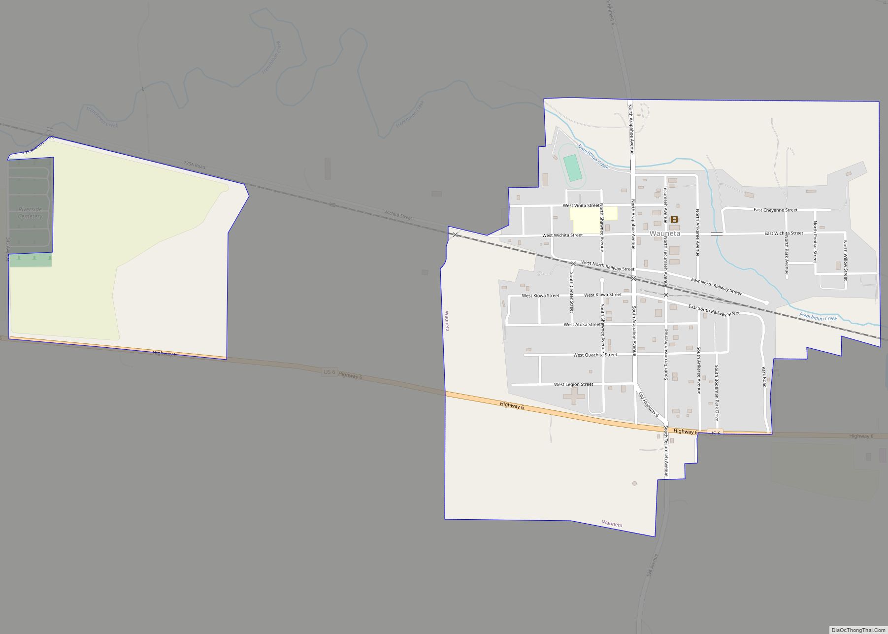
Wauneta is a village in Chase County, Nebraska, United States. The population was 577 at the 2010 census. It lies along U.S. Route 6, southeast of the city of Imperial, the county seat of Chase County. Its elevation is 2,942 feet (897 m). Wauneta’s ZIP code is 69045. Wauneta village overview: Name: Wauneta village LSAD Code: 47 … Read more

Map of Waterloo village, Nebraska

Map of Waterloo village, Nebraska

Waterloo is a village in Douglas County, Nebraska, United States. The population was 935 at the 2020 census. Waterloo village overview: Name: Waterloo village LSAD Code: 47 LSAD Description: village (suffix) State: Nebraska County: Douglas County Elevation: 1,119 ft (341 m) Total Area: 0.80 sq mi (2.08 km²) Land Area: 0.80 sq mi (2.08 km²) Water Area: 0.00 sq mi (0.00 km²) Total Population: 935 Population … Read more

Map of Waterbury village, Nebraska

Map of Waterbury village, Nebraska

Waterbury is a village in Dixon County, Nebraska, United States. It is part of the Sioux City, IA–NE–SD Metropolitan Statistical Area. The population was 73 at the 2010 census. Waterbury village overview: Name: Waterbury village LSAD Code: 47 LSAD Description: village (suffix) State: Nebraska County: Dixon County Elevation: 1,309 ft (399 m) Total Area: 0.14 sq mi (0.36 km²) Land … Read more

Map of Washington village, Nebraska

Map of Washington village, Nebraska

Washington is a village in Washington County, Nebraska, United States. The population was 150 at the 2010 census. Washington village overview: Name: Washington village LSAD Code: 47 LSAD Description: village (suffix) State: Nebraska County: Washington County Elevation: 1,148 ft (350 m) Total Area: 0.20 sq mi (0.53 km²) Land Area: 0.20 sq mi (0.53 km²) Water Area: 0.00 sq mi (0.00 km²) Total Population: 129 Population … Read more

Map of Wann CDP

Map of Wann CDP, Nebraska

Wann is an unincorporated community and census-designated place in Saunders County, Nebraska, United States. Wann CDP overview: Name: Wann CDP LSAD Code: 57 LSAD Description: CDP (suffix) State: Nebraska County: Saunders County Elevation: 1,083 ft (330 m) Total Area: 1.50 sq mi (3.89 km²) Land Area: 1.49 sq mi (3.86 km²) Water Area: 0.01 sq mi (0.03 km²) Total Population: 102 Population Density: 68.46/sq mi (26.44/km²) FIPS … Read more

Map of Walton CDP, Nebraska

Map of Walton CDP, Nebraska

Walton is an unincorporated community and census-designated place in Lancaster County, Nebraska, United States. Walton had a population of 306 as of the 2010 census. The headquarters of the Cornhusker Council of the Boy Scouts of America are located in Walton. Walton CDP overview: Name: Walton CDP LSAD Code: 57 LSAD Description: CDP (suffix) State: … Read more

Map of Walthill village

Map of Walthill village

Walthill is a village in Thurston County, Nebraska, United States, within the Omaha Reservation. The population was 780 at the 2010 census. Walthill village overview: Name: Walthill village LSAD Code: 47 LSAD Description: village (suffix) State: Nebraska County: Thurston County Elevation: 1,217 ft (371 m) Total Area: 0.43 sq mi (1.11 km²) Land Area: 0.43 sq mi (1.11 km²) Water Area: 0.00 sq mi (0.00 km²) … Read more

Map of Wallace village, Nebraska

Map of Wallace village, Nebraska

Wallace is a village in Lincoln County, Nebraska, United States. It is part of the North Platte, Nebraska Micropolitan Statistical Area. The population was 366 at the 2010 census. Wallace village overview: Name: Wallace village LSAD Code: 47 LSAD Description: village (suffix) State: Nebraska County: Lincoln County Elevation: 3,110 ft (948 m) Total Area: 0.71 sq mi (1.84 km²) Land … Read more

Map of Wakefield city, Nebraska

Map of Wakefield city, Nebraska

Wakefield is a city in Dixon and Wayne Counties in the State of Nebraska. The population was 1,451 at the 2010 census. The Dixon County portion of Wakefield is part of the Sioux City, IA–NE–SD Metropolitan Statistical Area. Wakefield city overview: Name: Wakefield city LSAD Code: 25 LSAD Description: city (suffix) State: Nebraska County: Dixon … Read more

Map of Western village

Map of Western village

Western is a village in Saline County, Nebraska, United States. The population was 224 at the 2020 census. Western village overview: Name: Western village LSAD Code: 47 LSAD Description: village (suffix) State: Nebraska County: Saline County Elevation: 1,493 ft (455 m) Total Area: 0.49 sq mi (1.26 km²) Land Area: 0.49 sq mi (1.26 km²) Water Area: 0.00 sq mi (0.00 km²) Total Population: 224 Population … Read more

Map of West Point city, Nebraska

Map of West Point city, Nebraska

West Point is a city in and the county seat of Cuming County, Nebraska, United States. The population was 3,504 at the 2020 census. West Point city overview: Name: West Point city LSAD Code: 25 LSAD Description: city (suffix) State: Nebraska County: Cuming County Elevation: 1,348 ft (411 m) Total Area: 2.85 sq mi (7.39 km²) Land Area: 2.84 sq mi (7.35 km²) … Read more