Map of Farmington city, New Mexico

Map of Farmington city, New Mexico

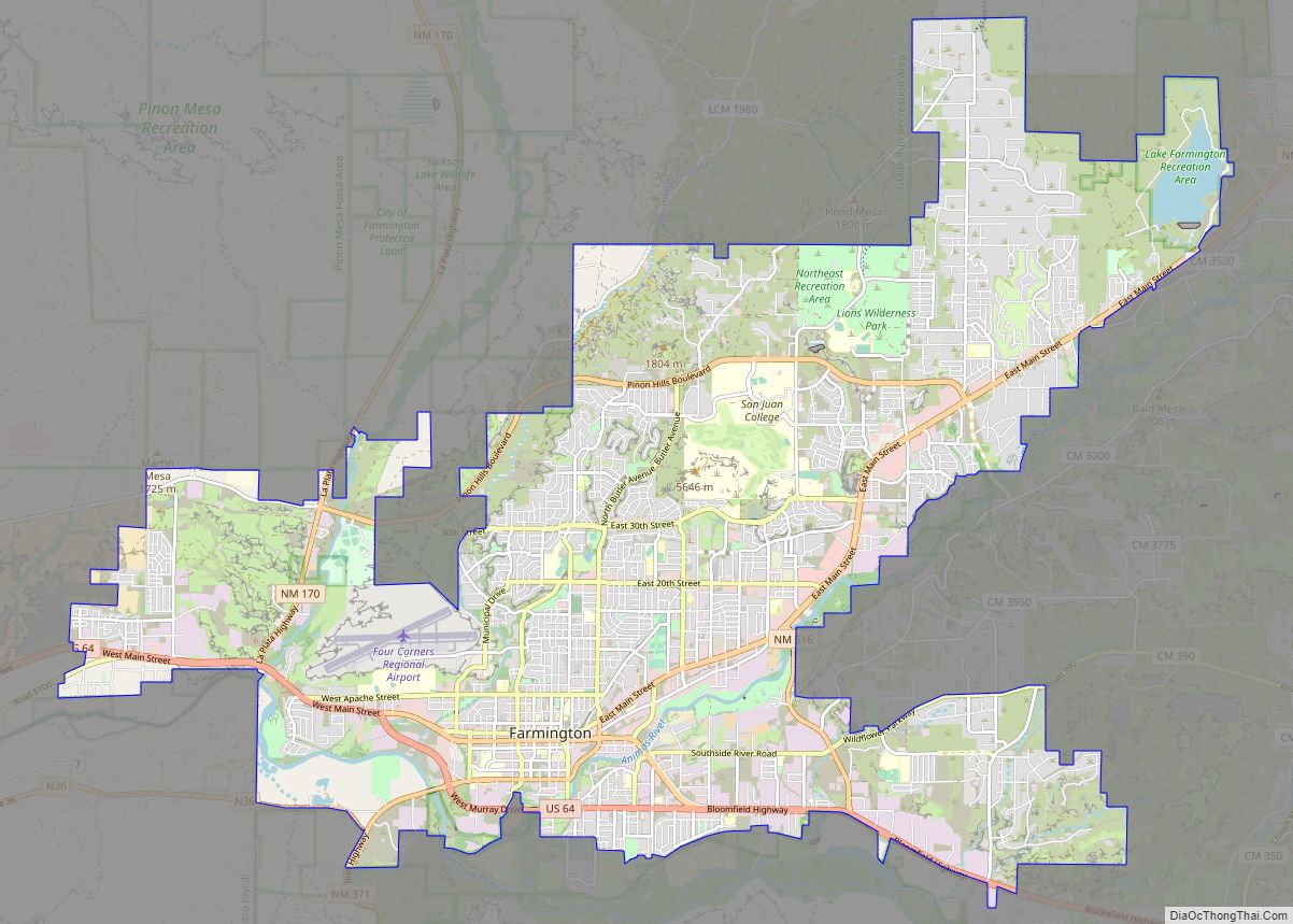
Farmington is a city in San Juan County in the U.S. state of New Mexico. As of the 2020 census the city had a population of 46,624 people. Farmington (and surrounding San Juan County) makes up one of the four metropolitan statistical areas (MSAs) in New Mexico. Farmington is located at the junction of the … Read more

Map of Fairacres CDP

Map of Fairacres CDP

Fairacres is a census-designated place and unincorporated community in Doña Ana County, New Mexico, United States. Its population was 824 as of the 2010 census. Fairacres has a post office with ZIP code 88033, which opened on June 15, 1926. U.S. Route 70 passes through the community. Fairacres CDP overview: Name: Fairacres CDP LSAD Code: … Read more

Map of Eunice city, New Mexico

Map of Eunice city, New Mexico

Eunice is a city in Lea County, New Mexico, United States. The population was 2,922 at the 2010 census. Eunice city overview: Name: Eunice city LSAD Code: 25 LSAD Description: city (suffix) State: New Mexico County: Lea County Elevation: 3,484 ft (1,062 m) Total Area: 4.10 sq mi (10.63 km²) Land Area: 4.09 sq mi (10.60 km²) Water Area: 0.01 sq mi (0.02 km²) Total Population: … Read more

Map of Estancia town

Map of Estancia town

Estancia is a town in Torrance County, New Mexico, United States. As of the 2020 census, the town population was 1,242. It is the county seat of Torrance County. Estancia is part of the Albuquerque Metropolitan Statistical Area. Estancia town overview: Name: Estancia town LSAD Code: 43 LSAD Description: town (suffix) State: New Mexico County: … Read more

Map of Española city

Map of Española city

Española city overview: Name: Española city LSAD Code: 25 LSAD Description: city (suffix) State: New Mexico County: Rio Arriba County, Santa Fe County FIPS code: 3525170 Online Interactive Map Española online map. Source: Basemap layers from Google Map, Open Street Map (OSM), Arcgisonline, Wmflabs. Boundary Data from Database of Global Administrative Areas. Española location map. … Read more

Map of Escudilla Bonita CDP

Map of Escudilla Bonita CDP

Escudilla Bonita is a census-designated place in Catron County, New Mexico, United States. Its population was 119 as of the 2010 census. Escudilla Bonita CDP overview: Name: Escudilla Bonita CDP LSAD Code: 57 LSAD Description: CDP (suffix) State: New Mexico County: Catron County Elevation: 7,316 ft (2,230 m) Total Area: 12.19 sq mi (31.58 km²) Land Area: 12.16 sq mi (31.49 km²) Water … Read more

Map of Fort Sumner village

Map of Fort Sumner village

Fort Sumner is a village in and the county seat of De Baca County, New Mexico, United States. The population was 1,031 at the 2010 U.S. Census, down from the figure of 1,249 recorded in 2000. Fort Sumner is the spring and fall home of the Columbia Scientific Balloon Facility, and is home to the … Read more

Map of Folsom village, New Mexico

Map of Folsom village, New Mexico

Folsom is a village in Union County, New Mexico, United States. Its population was 56 at the 2010 census, down from 75 in 2000. The town was named after Frances Folsom, the fiancée of President Grover Cleveland. Folsom village overview: Name: Folsom village LSAD Code: 47 LSAD Description: village (suffix) State: New Mexico County: Union … Read more

Map of Glorieta CDP

Map of Glorieta CDP

Glorieta is a census-designated place (CDP) in Santa Fe County, New Mexico, United States. It is part of the Albuquerque–Santa Fe–Las Vegas combined statistical area. The population was 430 at the 2010 census. The community is located in the southern Sangre de Cristo Mountains, along Interstate 25 on the east side of Glorieta Pass. Glorieta … Read more

Map of Glenwood CDP, New Mexico

Map of Glenwood CDP, New Mexico

Glenwood is a census-designated place in Catron County, New Mexico, United States. As of the 2010 census it had a population of 143. The area was founded in 1878 as Bush Ranch. Located near the San Francisco River, Glenwood is 61 miles (98 km) northwest of Silver City on U.S. Route 180, and is 38 miles … Read more

Map of Glen Acres CDP

Map of Glen Acres CDP

Glen Acres is a census-designated place in Hidalgo County, New Mexico, United States. Its population was 208 as of the 2010 census. The community is located along U.S. Route 70. The community’s streets are named after golfers (e.g. Sam Sneed (sic) Drive, Lee Trevino Drive, Tom Shaw Road). Glen Acres CDP overview: Name: Glen Acres … Read more

Map of Gila CDP

Map of Gila CDP

Gila is a census-designated place in Grant County, New Mexico, United States. It is 48 kilometres (30 mi) northwest of the county seat, Silver City. Its population was 314 as of the 2010 census. The community is located in the irrigated valley of the Gila River in the midst of hilly and mountainous semi-arid terrain. The … Read more