Map of Tesuque Pueblo CDP
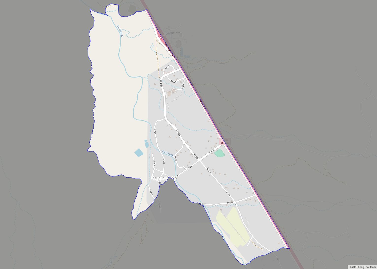
Tesuque Pueblo is an unincorporated community and census-designated place in Santa Fe County, New Mexico, United States. Its population was 233 as of the 2010 census. Tesuque Pueblo CDP overview: Name: Tesuque Pueblo CDP LSAD Code: 57 LSAD Description: CDP (suffix) State: New Mexico County: Santa Fe County Elevation: 6,371 ft (1,942 m) Total Area: 2.20 sq mi (5.69 km²) ... Read more
Map of Tesuque Pueblo CDP
Map of Tecolotito CDP
Tecolotito is an unincorporated community and census-designated place in San Miguel County, New Mexico, United States. The word “Tecolotito” has its origin in the Nahuatl language. Adopted into Spanish it means “small owl.” The population of the community was 232 as of the 2010 census, of which 213 people were of Hispanic origin. Tecolotito CDP ... Read more
Map of Tecolotito CDP
Map of Trout Valley CDP, New Mexico
Trout Valley is a census-designated place in Grant County, New Mexico, United States. Its population was 16 as of the 2010 census. New Mexico State Road 35 passes through the community. Trout Valley CDP overview: Name: Trout Valley CDP LSAD Code: 57 LSAD Description: CDP (suffix) State: New Mexico County: Grant County Elevation: 5,919 ft (1,804 m) ... Read more
Map of Trout Valley CDP, New Mexico
Map of Torreon CDP
Torreon is a farming community and census-designated place (CDP) in Torrance County, New Mexico, United States. The population was 244 at the 2000 census. It is part of the Albuquerque Metropolitan Statistical Area. Torreon CDP overview: Name: Torreon CDP LSAD Code: 57 LSAD Description: CDP (suffix) State: New Mexico County: Torrance County FIPS code: 3579140 ... Read more
Map of Torreon CDP
Map of Tyrone CDP, New Mexico
Tyrone is a census-designated place in Grant County, New Mexico, United States. Its population was 637 as of the 2010 census. Tyrone CDP overview: Name: Tyrone CDP LSAD Code: 57 LSAD Description: CDP (suffix) State: New Mexico County: Grant County Elevation: 5,745 ft (1,751 m) Total Area: 0.34 sq mi (0.87 km²) Land Area: 0.34 sq mi (0.87 km²) Water Area: 0.00 sq mi (0.00 km²) ... Read more
Map of Tyrone CDP, New Mexico
Map of Twin Lakes CDP, New Mexico
Twin Lakes (Navajo: Tsénáhádzoh, Bááhaztł’ah) is a census-designated place (CDP) in McKinley County, New Mexico, United States. The population was 1,069 at the 2000 census. Twin Lakes CDP overview: Name: Twin Lakes CDP LSAD Code: 57 LSAD Description: CDP (suffix) State: New Mexico County: McKinley County Elevation: 6,375 ft (1,943 m) Total Area: 9.02 sq mi (23.36 km²) Land Area: ... Read more
Map of Twin Lakes CDP, New Mexico
Map of Twin Forks CDP
Twin Forks is a census-designated place in Otero County, New Mexico, United States. Its population was 196 as of the 2010 census. U.S. Route 82 passes through the community. Twin Forks CDP overview: Name: Twin Forks CDP LSAD Code: 57 LSAD Description: CDP (suffix) State: New Mexico County: Otero County Elevation: 8,113 ft (2,473 m) Total Area: ... Read more
Map of Twin Forks CDP
Map of Tularosa village
Tularosa is a village in Otero County, New Mexico. It shares its name with the Tularosa Basin, in which the town is located. To the east, Tularosa is flanked by the western edge of the Sacramento Mountains. The population was 2,842 at the 2010 census. During the 1990s and early 2000s, the town, north of ... Read more
Map of Tularosa village
Map of Tucumcari city
Tucumcari (/ˈtuːkəmˌkæriː/; TOO-cum-carry) is a city in and the county seat of Quay County, New Mexico, United States. The population was 5,278 at the 2020 census. Tucumcari was founded in 1901, two years before Quay County was established. Tucumcari city overview: Name: Tucumcari city LSAD Code: 25 LSAD Description: city (suffix) State: New Mexico County: ... Read more
Map of Tucumcari city
Map of Tse Bonito CDP
Tse Bonito (Navajo: Tsé Binííʼtóhí) is a census-designated place (CDP) in McKinley County, New Mexico, United States and is part of the greater Window Rock, Arizona population center, and seat of the Navajo Nation government. The population was 261 at the 2000 census. Tse Bonito CDP overview: Name: Tse Bonito CDP LSAD Code: 57 LSAD ... Read more
Map of Tse Bonito CDP
Map of Truth or Consequences city
Truth or Consequences (often abbreviated as T or C), originally known as Hot Springs, New Mexico, is a city in the U.S. state of New Mexico, and the county seat of Sierra County. In 2020, the population was 6,052. It has frequently been noted on lists of unusual place names for having chosen to rename ... Read more
Map of Truth or Consequences city
Map of Truchas CDP
Truchas is a census-designated place in Rio Arriba County, New Mexico, United States. Located along the scenic High Road to Taos, it is halfway between Santa Fe in the south, and Taos to the north. Truchas has the ZIP code 87578. The 87578 ZIP Code Tabulation Area, which includes the nearby village of Cordova, New ... Read more
Map of Truchas CDP