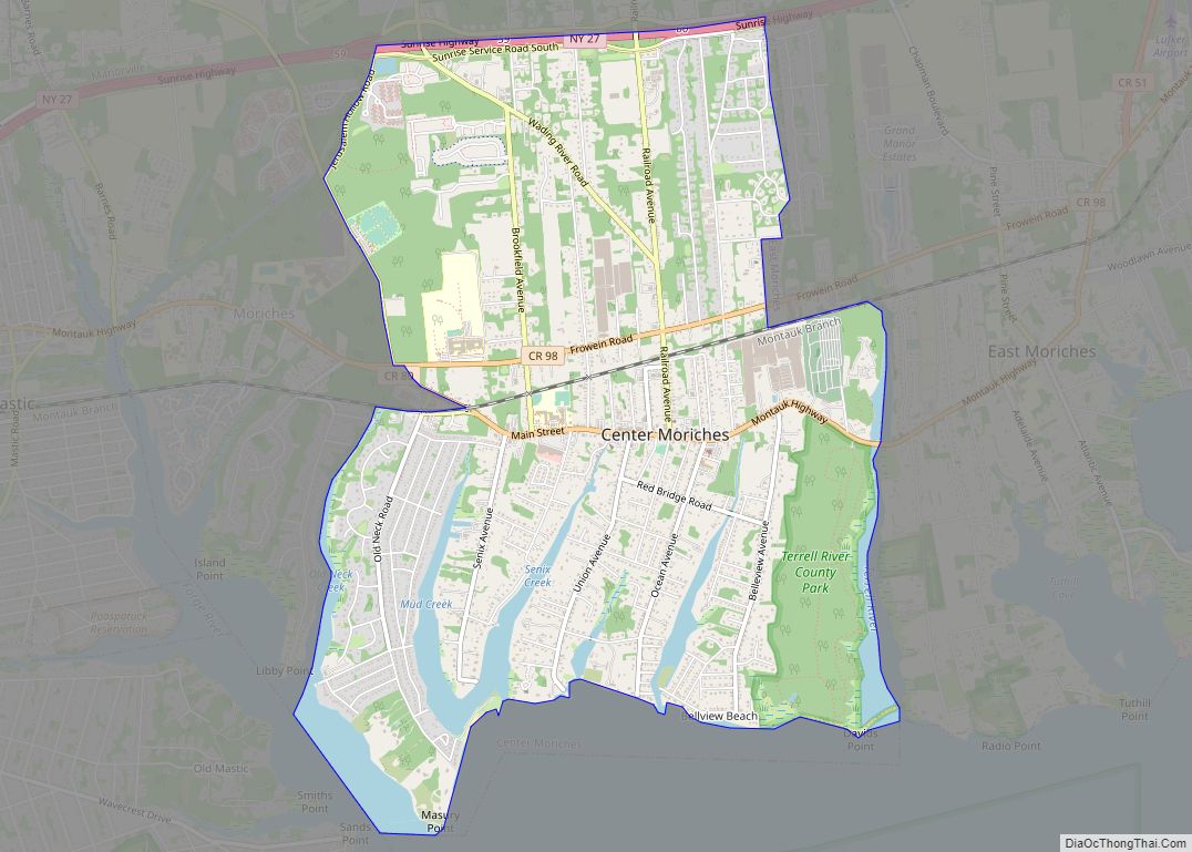
Map of Centre Island village
Centre Island is a village located within the Town of Oyster Bay in Nassau County, on Long Island, in New York, United States. Its population was 410 as of the 2010 census. Centre Island village overview: Name: Centre Island village LSAD Code: 47 LSAD Description: village (suffix) State: New York County: Nassau County Elevation: 33 ft ... Read more
Map of Centre Island village
Map of Central Square village
Central Square is a village in Oswego County, New York, United States. The population was 1,848 at the 2010 census. The Village of Central Square is located in the southern part of the Town of Hastings on Route 49 and U.S. Route 11. The village is west of Interstate 81. The village is northwest of ... Read more
Map of Central Square village
Map of Central Islip CDP
Central Islip (Also known as CI) is a hamlet and census-designated place (CDP) within the Town of Islip in Suffolk County, New York, United States. The population was 34,450 at the 2010 census. Central Islip CDP overview: Name: Central Islip CDP LSAD Code: 57 LSAD Description: CDP (suffix) State: New York County: Suffolk County Elevation: ... Read more
Map of Central Islip CDP
Map of Central Bridge CDP
Central Bridge is a hamlet and census-designated place (CDP) within the towns of Schoharie and Esperance in Schoharie County, New York, United States. As of the 2010 census, the population was 593. Central Bridge is in northeastern Schoharie County, in the northwestern part of the town of Schoharie and the southwestern section of Esperance. It ... Read more
Map of Central Bridge CDP
Map of Centerport CDP, New York
Centerport is a hamlet and census-designated place (CDP) in Suffolk County, New York, United States, on the notably affluent North Shore of Long Island, historically known as the Gold Coast. Formerly known as Little Cow Harbor in about 1700, as Centerport in 1836, and as Centerport after 1895, the name refers to its geographic position ... Read more
Map of Centerport CDP, New York
Map of Cherry Creek village, New York
Cherry Creek is a hamlet (and census-designated place) in Chautauqua County, New York, United States. The population was 461 at the 2010 census, when it was an incorporated village. The hamlet is within the town of Cherry Creek near the east border of the county. It is located on New York State Route 83 and ... Read more
Map of Cherry Creek village, New York
Map of Chenango Bridge CDP
Chenango Bridge is a hamlet in the southern part of the Town of Chenango in Broome County, New York, United States. It lies where State Route 12A (Chenango Bridge Road) crosses the Chenango River. The population was 2,883 at the 2010 census, which lists the community as a census-designated place. Chenango Bridge CDP overview: Name: ... Read more
Map of Chenango Bridge CDP
Map of Cheektowaga CDP
Cheektowaga is a suburban community and census-designated place (CDP) in Erie County, New York, United States. The population was 75,178 at the 2010 census, making it the most populous census-designated place in New York. It is within the town of Cheektowaga. The CDP includes Buffalo Niagara International Airport. Cheektowaga is part of the Buffalo–Niagara Falls ... Read more
Map of Cheektowaga CDP
Map of Chazy CDP
Chazy is a hamlet and census-designated place (CDP) in the town of Chazy, Clinton County, New York, United States. The population was 565 at the 2010 census, out of a total town population of 4,284. Chazy CDP overview: Name: Chazy CDP LSAD Code: 57 LSAD Description: CDP (suffix) State: New York County: Clinton County Elevation: ... Read more
Map of Chazy CDP
Map of Chautauqua CDP, New York
Chautauqua is a hamlet and census-designated place (CDP) in the town of Chautauqua in Chautauqua County, New York, United States. It corresponds to the area of the Chautauqua Institution, a historic district, adult education center, and summer resort on the southwest shore of Chautauqua Lake in far western New York. The permanent residential population was ... Read more
Map of Chautauqua CDP, New York
Map of Chaumont village
Chaumont (/ʃəˈmoʊ/ shə-MOH) is a village in Jefferson County, New York, United States. Its population was 624 at the 2010 census. The village is named for Jacques-Donatien Le Ray de Chaumont, son of Benjamin Franklin’s landlord and friend at Passy in France. The village of Chaumont is in the town of Lyme and is northwest ... Read more
Map of Chaumont village
Map of Chatham village, New York
Chatham /ˈtʃætəm/ is a village in Columbia County, New York, United States. The population was 1,770 at the 2010 census. The village of Chatham is on the border between the towns of Chatham and Ghent. The village is at the junction of Routes 66 and 203. Chatham village overview: Name: Chatham village LSAD Code: 47 ... Read more
Map of Chatham village, New York