Map of Cortland West CDP

Map of Cortland West CDP

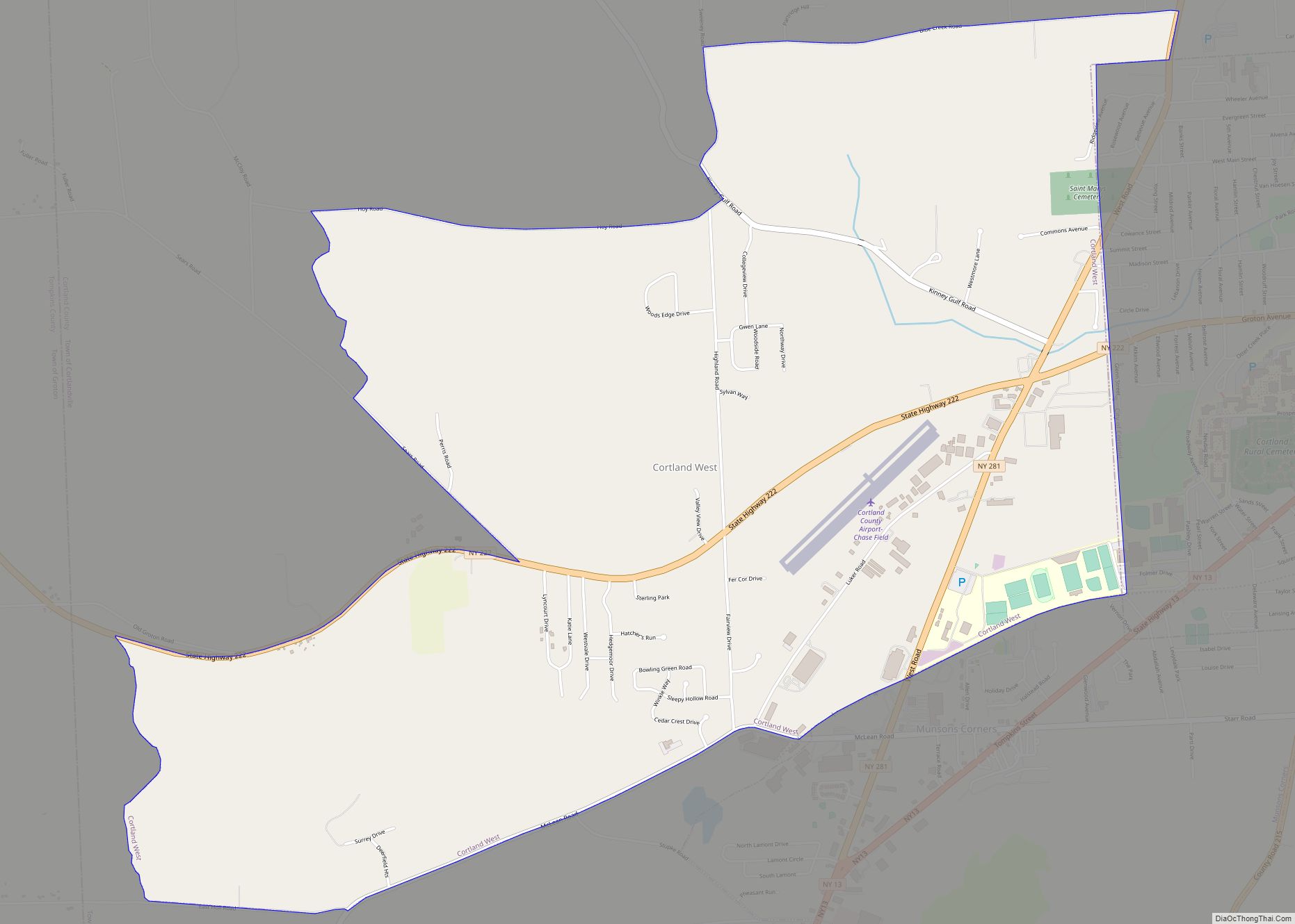
Cortland West is a census-designated place and region in Cortland County, New York, United States. The population was 1,356 at the 2010 census. The area known as Cortland West is in the town of Cortlandville, on the west side of the city of Cortland. Cortland West CDP overview: Name: Cortland West CDP LSAD Code: 57 … Read more

Map of Cornwall-on-Hudson village

Map of Cornwall-on-Hudson village

Cornwall-on-Hudson is a riverfront village in the town of Cornwall, Orange County, New York, United States. It lies on the west bank of the Hudson River, approximately 50 miles (80 km) north of New York City. The population as of the 2020 census was 3,075. It is part of the Poughkeepsie–Newburgh–Middletown metropolitan area as well as … Read more

Map of Corning city, New York

Map of Corning city, New York

Corning is a city in Steuben County, New York, United States, on the Chemung River. The population was 10,551 at the 2020 census. It is named for Erastus Corning, an Albany financier and railroad executive who was an investor in the company that developed the community. The city is best known as the headquarters of … Read more

Map of Corinth village, New York

Map of Corinth village, New York

Corinth (/ˈkɒrɪnθ/ KORR-inth) is a village in Saratoga County, New York, United States. The population was 2,559 at the 2010 census. The village takes its name from the Greek city of Corinth. The Village of Corinth is by the eastern town line of the Town of Corinth. The community asserts that it is the “Snowshoe … Read more

Map of Corfu village

Map of Corfu village

Corfu is a village in Genesee County, New York, United States. The population was 709 at the 2010 census. It is named after the Greek island of Corfu. The village of Corfu lies along the southern edge of the town of Pembroke; about 1.5 acres (0.6 ha) within the village limits are within the town of … Read more

Map of Crown Heights CDP

Map of Crown Heights CDP

Crown Heights is a hamlet and census-designated place (CDP) in Dutchess County, New York, United States. The population was 2,840 at the 2010 census. It is part of the Poughkeepsie–Newburgh–Middletown, NY Metropolitan Statistical Area as well as the larger New York–Newark–Bridgeport, NY-NJ–CT–PA Combined Statistical Area. Crown Heights is in the town of Poughkeepsie. Crown Heights … Read more

Map of Croton-on-Hudson village

Map of Croton-on-Hudson village

Croton-on-Hudson is a village in Westchester County, New York, United States. The population was 8,327 at the 2020 United States census over 8,070 at the 2010 census. It is located in the town of Cortlandt as part of New York City’s northern suburbs. The village was incorporated in 1898. Croton-on-Hudson village overview: Name: Croton-on-Hudson village … Read more

Map of Crompond CDP

Map of Crompond CDP

Crompond is a hamlet and census-designated place (CDP) located in the town of Yorktown in Westchester County, New York, United States. The population was 2,292 at the 2010 census. Crompond CDP overview: Name: Crompond CDP LSAD Code: 57 LSAD Description: CDP (suffix) State: New York County: Westchester County Elevation: 420 ft (128 m) Total Area: 2.44 sq mi (6.33 km²) … Read more

Map of Croghan village

Map of Croghan village

Croghan is a village in Lewis County, New York, United States. Its population was 618 at the 2010 census. The village is situated mainly in the southern part of the town of Croghan, with a small part in New Bremen. The town and the village were both named after George Croghan, a soldier in the … Read more

Map of Cranberry Lake CDP

Map of Cranberry Lake CDP

Cranberry Lake is a hamlet in the eastern part of the Town of Clifton, in St. Lawrence County, New York, United States. It lies along New York State Route 3 on the north shore of Cranberry Lake. The population was 200 at the 2010 census, which lists the community as a census-designated place. Cranberry Lake, … Read more

Map of Cumminsville CDP

Map of Cumminsville CDP

Cumminsville is a hamlet and census-designated place in the town of North Dansville, Livingston County, New York, United States. Its population was 183 as of the 2010 census. It is on the northwest edge of the village of Dansville, and Interstate 390 and New York State Route 36 pass through the community. Cumminsville CDP overview: … Read more

Map of Cumberland Head CDP

Map of Cumberland Head CDP

Cumberland Head is a census-designated place and region of the town of Plattsburgh in Clinton County, New York, United States. The population was 1,627 at the 2010 census. Cumberland Head is a peninsula projecting into Lake Champlain, and includes the communities of Rocky Point and Champlain Park. A landing for the Lake Champlain Transportation Company’s … Read more