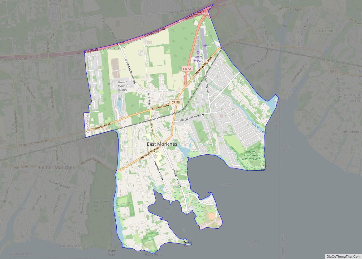
Map of East Massapequa CDP

Map of East Massapequa CDP

East Massapequa (formerly known as West Amityville) is a hamlet and census-designated place (CDP) located within the Town of Oyster Bay in Nassau County, on the South Shore of Long Island, in New York, United States. The population was 19,069 at the 2010 census. East Massapequa CDP overview: Name: East Massapequa CDP LSAD Code: 57 … Read more

Map of East Marion CDP

Map of East Marion CDP

East Marion is a census-designated place (CDP) that roughly corresponds to the hamlet by the same name in the town of Southold in Suffolk County, New York, United States. The CDP population was 926 at the 2010 census. East Marion CDP overview: Name: East Marion CDP LSAD Code: 57 LSAD Description: CDP (suffix) State: New … Read more

Map of East Kingston CDP

Map of East Kingston CDP

East Kingston is a hamlet (and census-designated place) in Ulster County, New York, United States. The population was 277 at the 2020 census. East Kingston is located in the southeastern corner of the Town of Ulster. The community is immediately north of the City of Kingston. East Kingston CDP overview: Name: East Kingston CDP LSAD … Read more

Map of East Ithaca CDP

Map of East Ithaca CDP

East Ithaca is a suburban community (and census-designated place) in Tompkins County, New York, United States. The population was 2,231 at the 2010 census. East Ithaca is a suburb of the City of Ithaca on its eastern city line and in the Town of Ithaca. East Ithaca is immediately south of the main campus of … Read more

Map of East Islip CDP

Map of East Islip CDP

East Islip is a hamlet and CDP in the Town of Islip, Suffolk County, New York, United States. At the time of the 2010 census, the CDP had a population of 14,475. East Islip CDP overview: Name: East Islip CDP LSAD Code: 57 LSAD Description: CDP (suffix) State: New York County: Suffolk County Elevation: 16 ft … Read more

Map of East Shoreham CDP

Map of East Shoreham CDP

East Shoreham is a hamlet and census-designated place (CDP) in the Suffolk County town of Brookhaven, New York, United States. The population was 6,841 at the 2020 census. East Shoreham CDP overview: Name: East Shoreham CDP LSAD Code: 57 LSAD Description: CDP (suffix) State: New York County: Suffolk County Elevation: 121 ft (37 m) Total Area: 6.71 sq mi … Read more

Map of East Rockaway village

Map of East Rockaway village

East Rockaway is a village in Nassau County, on the South Shore of Long Island, in New York, United States. The population was 9,818 at the 2010 census. The Incorporated Village of East Rockaway is at the edge of Rockaway Peninsula Proper in the town of Hempstead, adjacent to Hewlett Harbor, Hewlett, Rockville Centre, Lynbrook, … Read more

Map of East Rochester village

Map of East Rochester village, New York

East Rochester is a coterminous town and village located southeast of the City of Rochester in Monroe County, New York, United States. The village, home to approximately 6,600 people, is surrounded by Pittsford on the west side and by Perinton to the east. Most of the southern boundary is delimited by New York State Route … Read more

Map of East Randolph CDP

Map of East Randolph CDP

East Randolph is a hamlet, census-designated place, and former village in Cattaraugus County, New York, United States. The population was 620 at the 2010 census. East Randolph is adjacent to the northeast part of the former village of Randolph and is mostly within the town of Randolph, with a small part inside the town of … Read more

Map of East Quogue CDP

Map of East Quogue CDP

East Quogue is a hamlet and census-designated place (CDP) in the Town of Southampton in Suffolk County, on Long Island, in New York, United States. The population was 4,757 at the 2010 census. East Quogue CDP overview: Name: East Quogue CDP LSAD Code: 57 LSAD Description: CDP (suffix) State: New York County: Suffolk County Elevation: … Read more

Map of East Patchogue CDP

Map of East Patchogue CDP

East Patchogue (/ˈpætʃɒɡ/, PATCH-awg) is a census-designated place (CDP) in the Town of Brookhaven in Suffolk County, on the South Shore of Long Island, in New York, United States. The population was 22,469 at the 2010 census. The CDP is a proximate representation of the East Patchogue hamlet used for statistical purposes of the Census … Read more

Map of Eastport CDP, New York

Map of Eastport CDP, New York

Eastport is a hamlet and census-designated place (CDP) in Suffolk County, New York, on the South Shore of Long Island. The population was 1,831 at the 2010 census. Eastport CDP overview: Name: Eastport CDP LSAD Code: 57 LSAD Description: CDP (suffix) State: New York County: Suffolk County Elevation: 30 ft (9 m) Total Area: 4.58 sq mi (11.85 km²) Land … Read more