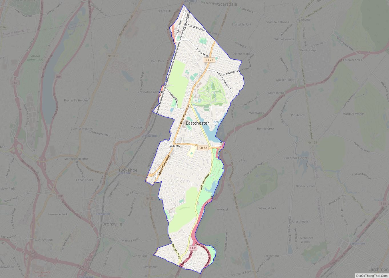
Map of East Randolph CDP

Map of East Randolph CDP

East Randolph is a hamlet, census-designated place, and former village in Cattaraugus County, New York, United States. The population was 620 at the 2010 census. East Randolph is adjacent to the northeast part of the former village of Randolph and is mostly within the town of Randolph, with a small part inside the town of … Read more

Map of East Quogue CDP

Map of East Quogue CDP

East Quogue is a hamlet and census-designated place (CDP) in the Town of Southampton in Suffolk County, on Long Island, in New York, United States. The population was 4,757 at the 2010 census. East Quogue CDP overview: Name: East Quogue CDP LSAD Code: 57 LSAD Description: CDP (suffix) State: New York County: Suffolk County Elevation: … Read more

Map of East Patchogue CDP

Map of East Patchogue CDP

East Patchogue (/ˈpætʃɒɡ/, PATCH-awg) is a census-designated place (CDP) in the Town of Brookhaven in Suffolk County, on the South Shore of Long Island, in New York, United States. The population was 22,469 at the 2010 census. The CDP is a proximate representation of the East Patchogue hamlet used for statistical purposes of the Census … Read more

Map of Eden CDP, New York

Map of Eden CDP, New York

Eden is a hamlet and census-designated place (CDP) in Erie County, New York, United States. The population was 3,516 at the 2010 census. It is part of the Buffalo–Niagara Falls Metropolitan Statistical Area. Eden is a community in the town of Eden, located on U.S. Route 62 in the western part of the town. Eden … Read more

Map of Eatons Neck CDP

Map of Eatons Neck CDP

Eatons Neck is a hamlet and census-designated place (CDP) in the Town of Huntington in Suffolk County, on the North Shore of Long Island, in New York, United States. The population was 1,406 at the 2010 census. There is a United States Coast Guard station at the northern tip of the hamlet. Eatons Neck CDP … Read more

Map of Ellicottville village

Map of Ellicottville village

Ellicottville is a village in Cattaraugus County, New York, United States. The population was 284 at the 2020 census. The village is named after Joseph Ellicott, principal land agent of the Holland Land Company. It lies in the southwest part of the town of Ellicottville and is north of the city of Salamanca. Ellicottville’s current … Read more

Map of Ellenville village

Map of Ellenville village

Ellenville is a village within the town of Wawarsing, Ulster County, New York, United States. Its population was 4,167 at the 2020 census. Ellenville village overview: Name: Ellenville village LSAD Code: 47 LSAD Description: village (suffix) State: New York County: Ulster County Elevation: 338 ft (103 m) Total Area: 8.78 sq mi (22.74 km²) Land Area: 8.69 sq mi (22.51 km²) Water Area: … Read more

Map of Elizabethtown CDP, New York

Map of Elizabethtown CDP, New York

Elizabethtown is a hamlet and census-designated place (CDP) in the town of Elizabethtown in Essex County, New York, United States. The population of the CDP was 754 at the 2010 census, out of a total town population of 1,163. Elizabethtown is the county seat of Essex County and the location of the town government. The … Read more

Map of Elbridge village

Map of Elbridge village

Elbridge is a village. Located in the western part of the town of Elbridge in western Onondaga County, New York, United States, about 15 miles (24 km) west of Syracuse. It is part of the Syracuse Metropolitan Statistical Area. As of the 2020 census, the population was 921. Elbridge village overview: Name: Elbridge village LSAD Code: … Read more

Map of Elba village, New York

Map of Elba village, New York

Elba is a village in Genesee County, New York, United States. The population was 676 at the 2010 census. The village is named after the island of Elba. The village of Elba is in the town of Elba. The village is north of Batavia at the intersection of NYS Route 98 and NYS Route 262. … Read more

Map of Eggertsville CDP

Map of Eggertsville CDP

Eggertsville is a hamlet and census-designated place (CDP) within the town of Amherst in Erie County, New York, United States. The population of the CDP was 15,019 at the 2010 census. Eggertsville is part of the Buffalo–Niagara Falls Metropolitan Statistical Area. Eggertsville CDP overview: Name: Eggertsville CDP LSAD Code: 57 LSAD Description: CDP (suffix) State: … Read more

Map of Edwards CDP, New York

Map of Edwards CDP, New York

Edwards is a hamlet (and census-designated place) in St. Lawrence County, New York, United States. The population was 439 at the 2010 census. It was an incorporated village until dissolution in 2012. The hamlet is in the northeast corner of the Town of Edwards. Both the former village and surrounding town are near the south … Read more