Map of Fort Montgomery CDP
Fort Montgomery is a hamlet (and census-designated place) in Orange County, New York, United States. The population was 1,627 at the 2020 census. It is part of the Poughkeepsie–Newburgh–Middletown, NY Metropolitan Statistical Area as well as the larger New York–Newark–Bridgeport, NY-NJ–CT–PA Combined Statistical Area. Fort Montgomery is in the southeastern corner of the town of ... Read more
Map of Fort Montgomery CDP
Map of Fort Johnson village
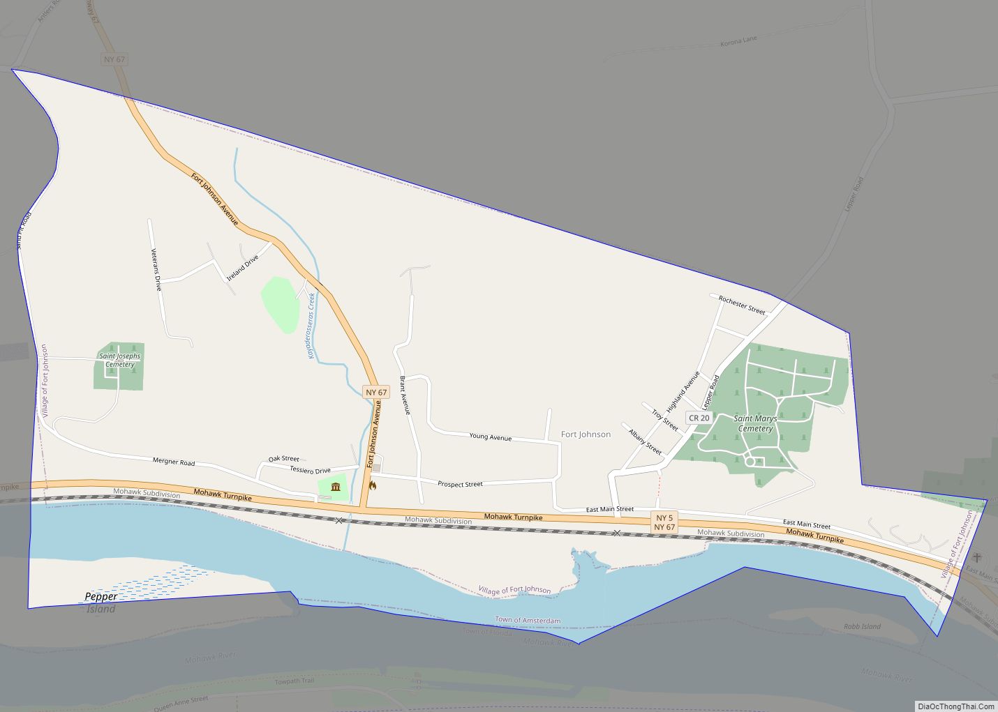
Fort Johnson (formerly known as Akin) is a village in Montgomery County, New York, United States located on the north side of the Mohawk River in the town of Amsterdam. The population was 490 at the 2010 census. Fort Johnson village overview: Name: Fort Johnson village LSAD Code: 47 LSAD Description: village (suffix) State: New ... Read more
Map of Fort Johnson village
Map of Fort Edward village
Fort Edward is a village in Washington County, New York, United States. It is part of the Glens Falls Metropolitan Statistical Area. The village population was 3,375 at the 2010 census. The name is derived from the younger brother of King George III, Edward Augustus, Duke of York and Albany. The village is part of ... Read more
Map of Fort Edward village
Map of Freeville village
Freeville is a village in Tompkins County, New York, United States. The population was 520 at the 2010 census. The Village of Freeville is in the Town of Dryden and is east of Ithaca. It is the only incorporated municipality in the United States named Freeville. Freeville village overview: Name: Freeville village LSAD Code: 47 ... Read more
Map of Freeville village
Map of Freeport village, New York
Freeport is a village in the town of Hempstead, in Nassau County, on the South Shore of Long Island, in New York state. The population was 43,713 at the 2010 census, making it the second largest village in New York by population. A settlement since the 1640s, it was once an oystering community and later ... Read more
Map of Freeport village, New York
Map of Freedom Plains CDP
Freedom Plains is a hamlet and census-designated place (CDP) in Dutchess County, New York, United States. As of the 2010 census the population was 421. Freedom Plains CDP overview: Name: Freedom Plains CDP LSAD Code: 57 LSAD Description: CDP (suffix) State: New York County: Dutchess County Elevation: 315 ft (96 m) Total Area: 1.33 sq mi (3.46 km²) Land Area: ... Read more
Map of Freedom Plains CDP
Map of Fredonia village, New York
Fredonia is a village in Chautauqua County, New York, United States. The population was 9,871 as of the 2020 census. Fredonia is in the town of Pomfret south of Lake Erie. The village is the home of the State University of New York at Fredonia (in the northwest part of the village). Fredonia is one ... Read more
Map of Fredonia village, New York
Map of Galeville CDP
Galeville is a hamlet (and census-designated place) in Onondaga County, New York, United States. The population was 4,617 at the 2010 census. The community is a northwestern suburb of Syracuse, located in the eastern end of the town of Salina. Galeville CDP overview: Name: Galeville CDP LSAD Code: 57 LSAD Description: CDP (suffix) State: New ... Read more
Map of Galeville CDP
Map of Gainesville village, New York
Gainesville is a village in Wyoming County, New York, United States. The population was 304 at the 2000 census. The village is named after General Edmund P. Gaines. The Village of Gainesville lies within the boundaries of the Town of Gainesville. The village is on NYS Route 19, south of NYS Route 78. Gainesville village ... Read more
Map of Gainesville village, New York
Map of Fultonville village
Fultonville is a village in Montgomery County, New York, United States. The village is named after Robert Fulton, inventor of the steamboat. The Fultonville Village is on the south bank of the Mohawk River in the Town of Glen. It is west of Amsterdam, and is sometimes jokingly referred to as South Fonda due to ... Read more
Map of Fultonville village
Map of Fulton city, New York
Fulton is a city in the western part of Oswego County, New York, United States. The population was 11,896 as of the 2010 census. The city is named after Robert Fulton, the inventor of the steamboat. Fulton city overview: Name: Fulton city LSAD Code: 25 LSAD Description: city (suffix) State: New York County: Oswego County ... Read more
Map of Fulton city, New York
Map of Friendship CDP, New York
Friendship is a hamlet (and census-designated place) in Allegany County, New York, United States. The population was 1,218 at the 2010 census. The community is the principal settlement in the town of Friendship. Friendship CDP overview: Name: Friendship CDP LSAD Code: 57 LSAD Description: CDP (suffix) State: New York County: Allegany County Elevation: 1,506 ft (459 m) ... Read more
Map of Friendship CDP, New York