Map of Ghent CDP, New York

Map of Ghent CDP, New York

Ghent is a census-designated place (CDP) in the town of Ghent in Columbia County, New York, United States. The population of the CDP was 564 at the 2010 census, out of a total town population of 5,402. The community is located northeast of the city of Hudson. Ghent was originally the site of a Mahican … Read more

Map of Germantown CDP, New York

Map of Germantown CDP, New York

Germantown is a census-designated place (CDP) in the town of Germantown in Columbia County, New York, United States, on the east side of the Hudson River. The population of the CDP was 845 at the 2010 census, out of a total town population of 1,954. Germantown CDP overview: Name: Germantown CDP LSAD Code: 57 LSAD … Read more

Map of Geneva city, New York

Map of Geneva city, New York

Geneva is a city in Ontario and Seneca counties in the U.S. state of New York. It is at the northern end of Seneca Lake; all land portions of the city are within Ontario County; the water portions are in Seneca County. The population was 13,261 at the 2010 census. The city is supposedly named … Read more

Map of Glen Park village

Map of Glen Park village

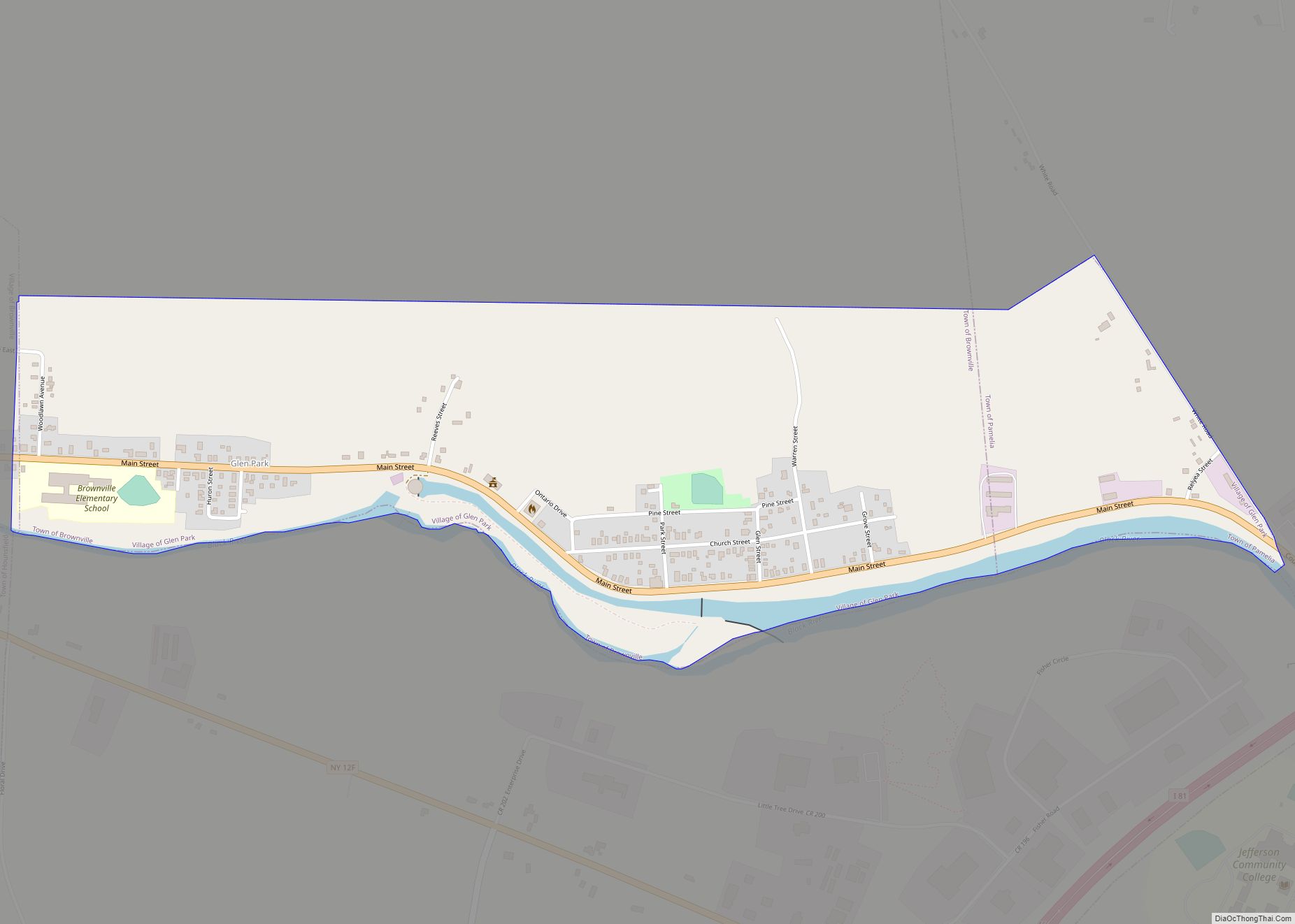
Glen Park is a village in Jefferson County, New York, United States. The population was 502 at the 2010 census. The village is on the border of the towns of Brownville and Pamelia and is immediately northwest of Watertown. Glen Park village overview: Name: Glen Park village LSAD Code: 47 LSAD Description: village (suffix) State: … Read more

Map of Glen Head CDP

Map of Glen Head CDP

Glen Head is a hamlet and census-designated place (CDP) located within the Town of Oyster Bay in Nassau County, on the North Shore of Long Island, in New York, United States. It is considered part of the greater Glen Cove area, which is anchored by the City of Glen Cove. The population was 4,837 at … Read more

Map of Glen Cove city

Map of Glen Cove city

Glen Cove is a city in Nassau County, New York, United States, on the North Shore of Long Island. At the 2020 United States Census, the city population was 28,365 as of the 2020 census. The city was considered part of the early 20th century Gold Coast of the North Shore, as the areas along … Read more

Map of Glen Aubrey CDP

Map of Glen Aubrey CDP

Glen Aubrey is a hamlet (and census-designated place) located in the town of Nanticoke in Broome County, New York, United States. Its population was 485 at the 2010 census. Glen Aubrey CDP overview: Name: Glen Aubrey CDP LSAD Code: 57 LSAD Description: CDP (suffix) State: New York County: Broome County Elevation: 990 ft (300 m) Total Area: … Read more

Map of Glasco CDP, New York

Map of Glasco CDP, New York

Glasco is a hamlet (and census-designated place) in Ulster County, New York, United States. The population was 2,013 at the 2020 census. Glasco is a community in the Town of Saugerties east of U.S. Route 9W. The community is north of Kingston. Glasco CDP overview: Name: Glasco CDP LSAD Code: 57 LSAD Description: CDP (suffix) … Read more

Map of Gilgo CDP

Map of Gilgo CDP

Gilgo is a hamlet and census-designated place (CDP) in the Town of Babylon in Suffolk County, New York, United States. The population was 131 at the 2010 census. Prior to the 2010 census, the area was part of a larger CDP called Gilgo-Oak Beach-Captree. The Gilgo CDP contains several small beach communities on a barrier … Read more

Map of Gowanda village

Map of Gowanda village

Gowanda is a village in western New York, United States. It lies partly in Erie County and partly in Cattaraugus County. The population was 2,512 at the 2020 census. The name is derived from a local Seneca language term meaning “almost surrounded by hills” or “a valley among the hills”. The Erie County portion of … Read more

Map of Gouverneur village

Map of Gouverneur village

Gouverneur is a village in St. Lawrence County, New York, United States. The population was 3,949 at the 2010 census. The village is named after Gouverneur Morris, one of the authors of the Constitution of the United States, as well as a prominent landowner and part-time resident of the area. The Village of Gouverneur is … Read more

Map of Goshen village, New York

Map of Goshen village, New York

Goshen is a village in and the county seat of Orange County, New York, United States. The population was 5,777 at the 2020 census. It is part of the Poughkeepsie–Newburgh–Middletown metropolitan area as well as the larger New York metropolitan area. The village is within the town of Goshen, some fifty miles northwest of New … Read more