Map of Hermon CDP

Map of Hermon CDP

Hermon is a hamlet (and census-designated place) in St. Lawrence County, New York, United States. The population was 422 at the 2010 census. The hamlet is in the northern part of the Town of Hermon and is southwest of Canton. It was an incorporated village from 1887 to 2016. Hermon CDP overview: Name: Hermon CDP … Read more

Map of Herkimer village

Map of Herkimer village

Herkimer is a village on the north side of the Mohawk River and the county seat of Herkimer County, New York, United States, about 15 miles (24 km) southeast of Utica. As of the 2020 Census, it had a population of 7,234, and a predicted population of 7,283 on July 1, 2022. It was part of … Read more

Map of Heritage Hills CDP

Map of Heritage Hills CDP

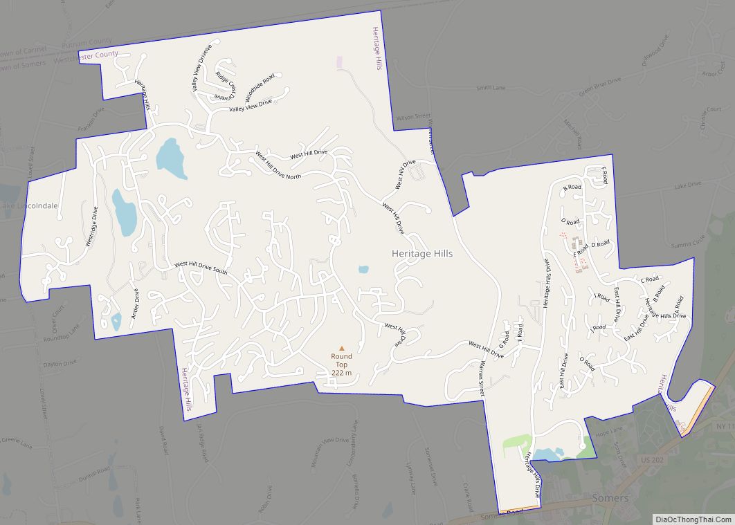
Heritage Hills is a hamlet (and census-designated place) (CDP) located in the town of Somers in Westchester County, New York, United States. The population was 3,975 at the 2010 census. Heritage Hills CDP overview: Name: Heritage Hills CDP LSAD Code: 57 LSAD Description: CDP (suffix) State: New York County: Westchester County Elevation: 587 ft (179 m) Total … Read more

Map of Henderson CDP, New York

Map of Henderson CDP, New York

Henderson is a hamlet and census-designated place (CDP) in the town of Henderson, Jefferson County, New York, United States. The population of the CDP was 224 at the 2010 census, out of 1,360 in the entire town of Henderson. Henderson CDP overview: Name: Henderson CDP LSAD Code: 57 LSAD Description: CDP (suffix) State: New York … Read more

Map of Hemlock CDP, New York

Map of Hemlock CDP, New York

Hemlock is a hamlet and census-designated place (CDP) in the town of Livonia, Livingston County, New York, United States. The population was 557 as of the 2010 census. The Hemlock post office has a ZIP Code of 14466 and serves the southeast part of the town of Livonia as well as parts of the towns … Read more

Map of Head of the Harbor village

Map of Head of the Harbor village

Head of the Harbor is a village in Suffolk County, on the North Shore of Long Island, New York, United States. The population was 1,472 at the time of the 2010 census. The Village of Head of the Harbor is located entirely within the Town of Smithtown. Head of the Harbor village overview: Name: Head … Read more

Map of Hawthorne CDP, New York

Map of Hawthorne CDP, New York

Hawthorne is a hamlet and census-designated place (CDP) located in the town of Mount Pleasant in Westchester County, New York, United States. The population was 4,586 at the 2010 census. Hawthorne CDP overview: Name: Hawthorne CDP LSAD Code: 57 LSAD Description: CDP (suffix) State: New York County: Westchester County Elevation: 282 ft (86 m) Total Area: 1.10 sq mi … Read more

Map of Hewlett Harbor village

Map of Hewlett Harbor village

Hewlett Harbor is a village in Nassau County, on Long Island, in New York, United States. The population was 1,263 as of the 2010 census. The Village of Hewlett Harbor is located within the Town of Hempstead. This area, like Back/Old Lawrence is unique because its rural affluence is similar in character to the more … Read more

Map of Hewlett Bay Park village

Map of Hewlett Bay Park village

Hewlett Bay Park is a village in the Town of Hempstead in Nassau County, on the South Shore of Long Island, in New York. The population was 404 at the 2010 census. The area, like Back/Old Lawrence is unique because its rural affluence is similar in character to the more well known Gold Coast of … Read more

Map of Hillcrest CDP, New York

Map of Hillcrest CDP, New York

Hillcrest is a hamlet incorporated in 1893 and census-designated place, in the town of Ramapo, Rockland County, New York, United States. It is located north of Spring Valley, east of Viola, south of New Square and New Hempstead, and west of New City. The population was 8,164 at the 2020 census. It is a bedroom … Read more

Map of Hillburn village

Map of Hillburn village

Hillburn, originally called “Woodburn” and incorporated in 1893, is a village in the town of Ramapo, Rockland County, New York, United States. It is located north of Suffern, east of Orange County, south of Viola, and west of Montebello. It is considered to be one of the more rural communities in Rockland County. The population … Read more

Map of Highland CDP, New York

Map of Highland CDP, New York

Highland /ˈhaɪˌlænd/ is a hamlet (and census-designated place) in Ulster County, New York, United States. The population was 6,385 at the 2020 census. It is part of the New York City Combined Statistical area. Highland is a community in the town of Lloyd, on U.S. Route 9W. Routes 44 and 55 run through it as … Read more