Map of Highland Falls village

Map of Highland Falls village

Highland Falls, formerly named Buttermilk Falls, is a village in Orange County, New York, United States. The population was 3,684 at the 2020 census. The village was founded in 1906. It is part of the Poughkeepsie–Newburgh–Middletown, NY Metropolitan Statistical Area as well as the larger New York–Newark–Bridgeport, NY-NJ–CT–PA Combined Statistical Area. Highland Falls is in … Read more

Map of High Falls CDP

Map of High Falls CDP

High Falls is a hamlet (and census-designated place) in Ulster County, New York, United States. The population was 700 at the 2020 census. Portions of High Falls are located in the towns of Marbletown, Rosendale, and Rochester. High Falls CDP overview: Name: High Falls CDP LSAD Code: 57 LSAD Description: CDP (suffix) State: New York … Read more

Map of Hicksville CDP

Map of Hicksville CDP, New York

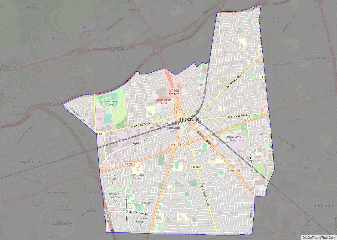
Hicksville is a hamlet and census-designated place (CDP) within the Town of Oyster Bay in Nassau County, on Long Island, in New York. The population of the CDP was 43,869 at the 2020 census. Hicksville CDP overview: Name: Hicksville CDP LSAD Code: 57 LSAD Description: CDP (suffix) State: New York County: Nassau County Elevation: 148 ft … Read more

Map of Hewlett CDP

Map of Hewlett CDP

Hewlett is a hamlet and census-designated place (CDP) in the Town of Hempstead in Nassau County, on Long Island, in New York, United States. The population was 6,819 at the 2010 census. Hewlett is usually included as one of the Five Towns in the southwestern corner of Nassau County. In the context of the Five … Read more

Map of Hewlett Neck village

Map of Hewlett Neck village

Hewlett Neck is a village in the Town of Hempstead in Nassau County, on Long Island, in New York, United States. The population was 445 at the time of the 2010 census. The Incorporated Village of Hewlett Neck is included in the Five Towns, which is usually said to comprise the villages of Lawrence and … Read more

Map of Holley village, New York

Map of Holley village, New York

Holley is a village in the town of Murray in Orleans County, New York, United States. The population was 1,811 at the 2010 census. It is part of the Rochester Metropolitan Statistical Area. Holley village overview: Name: Holley village LSAD Code: 47 LSAD Description: village (suffix) State: New York County: Orleans County Elevation: 541 ft (165 m) … Read more

Map of Holland CDP, New York

Map of Holland CDP, New York

Holland is a hamlet and census-designated place (CDP) in Erie County, New York, United States. The population was 1,206 at the 2010 census. It is in the town of Holland and is part of the Buffalo–Niagara Falls Metropolitan Statistical Area. Holland CDP overview: Name: Holland CDP LSAD Code: 57 LSAD Description: CDP (suffix) State: New … Read more

Map of Holland Patent village

Map of Holland Patent village

Holland Patent is a village in Oneida County, New York, United States. The population was 458 at the 2010 census. The village is named after a land grant. The Village of Holland Patent is in the western part of the Town of Trenton at the junction of Routes 274, 291, and 365. Holland Patent village … Read more

Map of Holbrook CDP, New York

Map of Holbrook CDP, New York

Holbrook is a hamlet and census-designated place (CDP) in Suffolk County, New York, United States. The population was 27,195 at the 2010 census. The community borders the eastern side of Long Island MacArthur Airport. Holbrook CDP overview: Name: Holbrook CDP LSAD Code: 57 LSAD Description: CDP (suffix) State: New York County: Suffolk County Elevation: 118 ft … Read more

Map of Hobart village, New York

Map of Hobart village, New York

Hobart is a village in Delaware County, New York, United States. The population was 441 at the 2010 census. The village is in the town of Stamford and is on New York Route 10 in the northeastern part of the county. Hobart village overview: Name: Hobart village LSAD Code: 47 LSAD Description: village (suffix) State: … Read more

Map of Hilton village

Map of Hilton village

Hilton is a village in Monroe County, New York, United States. The population was 5,886 at the 2010 census. The community was named for the Rev. Charles A. Hilton. The Village of Hilton is within the Town of Parma. Hilton village overview: Name: Hilton village LSAD Code: 47 LSAD Description: village (suffix) State: New York … Read more

Map of Hillside CDP, New York

Map of Hillside CDP, New York

Hillside is a census-designated place (CDP) in Wyoming County, New York, United States. Hillside CDP overview: Name: Hillside CDP LSAD Code: 57 LSAD Description: CDP (suffix) State: New York County: Ulster County FIPS code: 3634786 Online Interactive Map Hillside online map. Source: Basemap layers from Google Map, Open Street Map (OSM), Arcgisonline, Wmflabs. Boundary Data … Read more