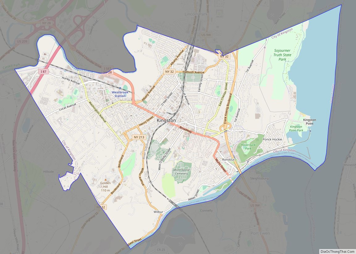
Map of Kerhonkson CDP
Kerhonkson /kərˈhɒŋksən/ is a hamlet and census-designated place (CDP) in Ulster County, New York, United States. The population was 1,722 at the 2020 census. The Kerhonkson CDP is an urban concentration that straddles the border of the town of Rochester and the town of Wawarsing, with the larger portion in Rochester. US 209 is the ... Read more
Map of Kerhonkson CDP
Map of Kensington village, New York
Kensington is a village in Nassau County, on the North Shore of Long Island, in New York, United States. The population was 1,161 at the 2010 census. The Incorporated Village of Kensington is in the Town of North Hempstead and is on the Great Neck Peninsula. Kensington village overview: Name: Kensington village LSAD Code: 47 ... Read more
Map of Kensington village, New York
Map of Kennedy CDP, New York
Kennedy is a hamlet and census-designated place (CDP) in the town of Poland in Chautauqua County, New York, United States. The population was 465 at the 2010 census. From 1805–1841, the hamlet was known as Kennedy Mills, in honor of Thomas Ruston Kennedy, the founder of the local mills. The name was changed in 1841 ... Read more
Map of Kennedy CDP, New York
Map of Kenmore village, New York
Kenmore is a village in Erie County, New York, United States. The population was 15,423 at the 2010 census. It is part of the Buffalo–Niagara Falls metropolitan area. Kenmore is in the south part of the town of Tonawanda, and together with the town it is often referred to as “Ken-Ton”. It is bordered to ... Read more
Map of Kenmore village, New York
Map of Keeseville CDP
Keeseville is a hamlet (and census-designated place) in Clinton and Essex counties, New York, United States. The population was 1,815 at the 2010 census. The hamlet was named after the Keese family, early settlers from Vermont. It developed along the Ausable River, which provided water power for mills and industrial development. Keeseville is in the ... Read more
Map of Keeseville CDP
Map of Lacona village, New York
Lacona is a village in Oswego County, New York, United States. The population was 582 at the 2010 census. The Village of Lacona is inside the Town of Sandy Creek. The village is halfway between Syracuse and Watertown. Lacona village overview: Name: Lacona village LSAD Code: 47 LSAD Description: village (suffix) State: New York County: ... Read more
Map of Lacona village, New York
Map of Lackawanna city
Lackawanna is a city in Erie County, New York, United States, just south of the city of Buffalo in western New York State. The population was 19,949 at the 2020 census. It is one of the fastest-growing cities in New York, growing in population by 10% from 2010 to 2020. It is part of the ... Read more
Map of Lackawanna city
Map of La Fargeville CDP
La Fargeville is a hamlet and census-designated place (CDP) in the town of Orleans in Jefferson County, New York, United States. The population was 608 at the 2010 census. The hamlet is named after John Frederick La Farge, one of the early proprietors of the town. La Fargeville was once a village, but dissolved its ... Read more
Map of La Fargeville CDP
Map of Kysorville CDP
Kysorville is a hamlet and census-designated place (CDP) in the town of West Sparta, Livingston County, New York, United States. Its population was 110 as of the 2010 census. Kysorville CDP overview: Name: Kysorville CDP LSAD Code: 57 LSAD Description: CDP (suffix) State: New York County: Livingston County Elevation: 623 ft (190 m) Total Area: 0.82 sq mi (2.11 km²) ... Read more
Map of Kysorville CDP
Map of Kiryas Joel village
Kiryas Joel (Yiddish: קרית יואל, romanized: Kiryas Yoyel, Yiddish pronunciation: [ˈkɪr.jəs ˈjɔɪ.əl]; often locally abbreviated as KJ) is a village coterminous with the Town of Palm Tree in Orange County, New York, United States. The village shares one government with the Town. The vast majority of its residents are Yiddish-speaking Hasidic Jews who belong to the worldwide ... Read more
Map of Kiryas Joel village
Map of Lake Katrine CDP
Lake Katrine is a hamlet (and census-designated place (CDP)) in Ulster County, New York, United States. The population was 2,522 at the 2020 census. Lake Katrine is a community in the western part of the Town of Ulster, located near a small lake, also called Lake Katrine. The hamlet is north of the City of ... Read more
Map of Lake Katrine CDP
Map of Lake Grove village
Lake Grove is a village in the Town of Brookhaven in Suffolk County, New York, United States. The population was 11,163 at the 2010 census. Lake Grove village overview: Name: Lake Grove village LSAD Code: 47 LSAD Description: village (suffix) State: New York County: Suffolk County Incorporated: September 9, 1968 Elevation: 118 ft (36 m) Total Area: ... Read more
Map of Lake Grove village