Map of Aurora village, New York
Aurora, or Aurora-on-Cayuga, is a village and college town in the town of Ledyard, Cayuga County, New York, United States, on the shore of Cayuga Lake. The village had a population of 724 at the 2010 census. Wells College, an institution of higher education for women founded by Henry Wells in 1868, is located in ... Read more
Map of Aurora village, New York
Map of Auburn city, New York
Auburn is a city in Cayuga County, New York, United States. Located at the north end of Owasco Lake, one of the Finger Lakes in Central New York, the city had a population of 26,866 at the 2020 census. It is the largest city of Cayuga County, the county seat, and the site of the ... Read more
Map of Auburn city, New York
Map of Au Sable Forks CDP
Au Sable Forks is a hamlet in Clinton County and Essex County, New York, United States. The northern half of the community, within Clinton County, is listed as the Au Sable Forks census-designated place (CDP) and had a population of 559 at the 2010 census. Au Sable Forks CDP overview: Name: Au Sable Forks CDP ... Read more
Map of Au Sable Forks CDP
Map of Attica village, New York
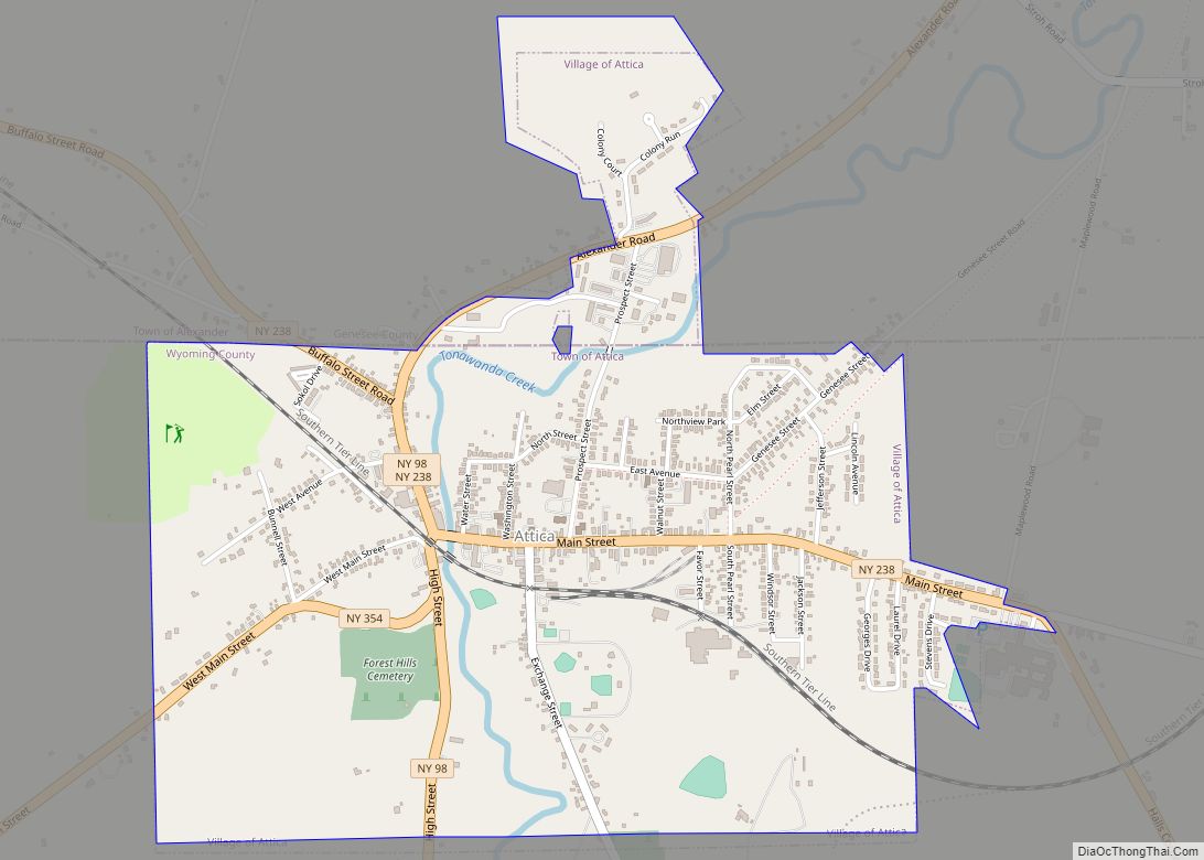
Attica is a village in Wyoming and Genesee counties, New York, United States. The population was 2,547 at the 2010 census. The village is on the northern border of Wyoming County. The village lies mostly within the town of Attica, but the northern part of the village is within the adjacent town of Alexander in ... Read more
Map of Attica village, New York
Map of Atlantic Beach village, New York
Atlantic Beach is a village located off the South Shore of Long Island in the Town of Hempstead, Nassau County, New York, United States. As of the 2020 United States Census, the village population was 1,707. The incorporated village of Atlantic Beach is located on Long Beach Barrier Island, one of the outer barrier islands ... Read more
Map of Atlantic Beach village, New York
Map of Balmville CDP
Balmville is a hamlet (and census-designated place) in Orange County, New York, United States. It is part of the Poughkeepsie–Newburgh–Middletown, NY Metropolitan Statistical Area as well as the larger New York–Newark–Bridgeport, NY-NJ–CT–PA Combined Statistical Area. It is located in the southeastern part of the Town of Newburgh. The population was 3,197 at the 2020 census. ... Read more
Map of Balmville CDP
Map of Ballston Spa village
Ballston Spa is a village and the county seat of Saratoga County, New York, United States, located southwest of Saratoga Springs. The population of the village, named after Rev. Eliphalet Ball, a Congregationalist clergyman and an early settler, was 5,111 at the 2020 census. Ballston Spa lies on the border of two towns, situated partly ... Read more
Map of Ballston Spa village
Map of Baldwinsville village
Baldwinsville is a village in Onondaga County, New York, United States. As of the 2020 census, the population was 7,898. It is part of the Syracuse Metropolitan Statistical Area. Baldwinsville (the village itself) is located in the towns of Lysander and Van Buren. Baldwinsville mailing addresses also include a small northwestern section of the town ... Read more
Map of Baldwinsville village
Map of Baldwin CDP, New York
Baldwin is a hamlet located in the Town of Hempstead in Nassau County, on Long Island, New York, United States. It had a population of 33,919 in 2020. Baldwin CDP overview: Name: Baldwin CDP LSAD Code: 57 LSAD Description: CDP (suffix) State: New York County: Nassau County Elevation: 23 ft (7.0104 m) Total Area: 24,033 ZIP code: ... Read more
Map of Baldwin CDP, New York
Map of Baldwin Harbor CDP
Baldwin Harbor CDP overview: Name: Baldwin Harbor CDP LSAD Code: 57 LSAD Description: CDP (suffix) State: New York County: Nassau County FIPS code: 3604154 Online Interactive Map Baldwin Harbor online map. Source: Basemap layers from Google Map, Open Street Map (OSM), Arcgisonline, Wmflabs. Boundary Data from Database of Global Administrative Areas. Baldwin Harbor location map. ... Read more
Map of Baldwin Harbor CDP
Map of Baiting Hollow CDP
Baiting Hollow is a census-designated place (CDP) roughly corresponding to the hamlet by the same name in the Town of Riverhead in Suffolk County, on Long Island, in New York, United States. The CDP’s population was 1,642 at the 2010 census. Baiting Hollow CDP overview: Name: Baiting Hollow CDP LSAD Code: 57 LSAD Description: CDP ... Read more
Map of Baiting Hollow CDP
Map of Bainbridge village, New York
Bainbridge is a village in Chenango County, New York, United States. The population was 1,355 at the 2010 census. The village is at the center of the town of Bainbridge and lies between Binghamton and Oneonta. Bainbridge village overview: Name: Bainbridge village LSAD Code: 47 LSAD Description: village (suffix) State: New York County: Chenango County ... Read more
Map of Bainbridge village, New York