Map of McGraw village

Map of McGraw village

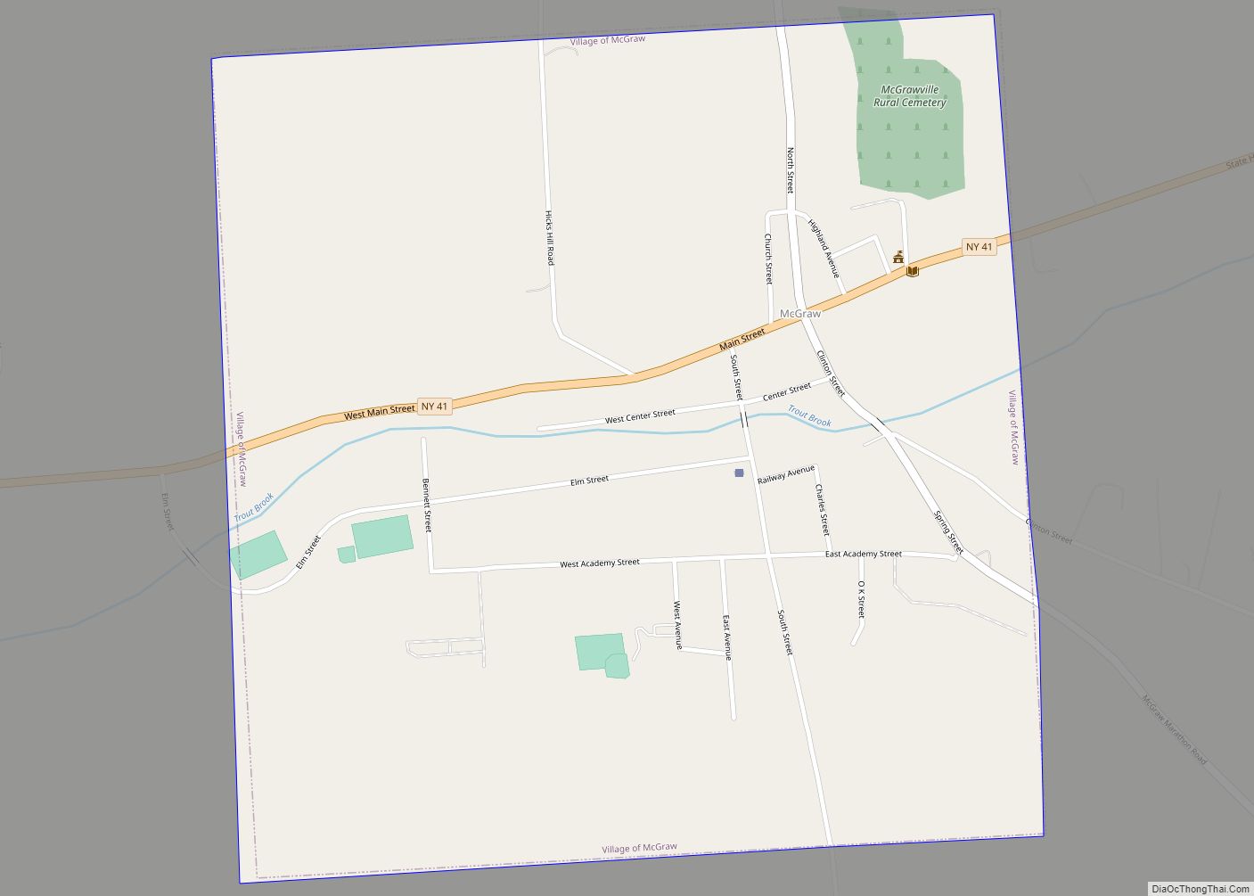
McGraw is a village in Cortland County, New York, United States. The population was 972 as of the 2020 census. The village is named after Samuel McGraw and is in the eastern part of the town of Cortlandville, east of the city of Cortland. McGraw village overview: Name: McGraw village LSAD Code: 47 LSAD Description: … Read more

Map of Mayville village, New York

Map of Mayville village, New York

Mayville is a village in Chautauqua County, New York, United States. The population was 1,477 at the 2020 census, 13.7% less than in the 2010 census. Mayville is in the town of Chautauqua and is the county seat of Chautauqua County. The village and town offices share a building on Main Street, directly across from … Read more

Map of Mayfield village, New York

Map of Mayfield village, New York

Mayfield is a village in Fulton County, New York, United States, located in the center of the town of Mayfield, northeast of Gloversville. As of the 2010 census, the village population was 832. Mayfield village overview: Name: Mayfield village LSAD Code: 47 LSAD Description: village (suffix) State: New York County: Fulton County Elevation: 850 ft (259 m) … Read more

Map of Maybrook village

Map of Maybrook village

Maybrook is a village in Orange County, New York, United States. The population was 3,150 at the 2020 census. It is part of the Poughkeepsie–Newburgh–Middletown, NY Metropolitan Statistical Area as well as the larger New York–Newark–Bridgeport, NY-NJ–CT–PA Combined Statistical Area. It is located mostly in the town of Montgomery, but a small portion is in … Read more

Map of Mattydale CDP

Map of Mattydale CDP

Mattydale is a hamlet (and census-designated place) in Onondaga County, New York, United States. The population was 6,446 at the 2010 census. Mattydale is a community in the northeast part of the town of Salina and is a northern suburb of Syracuse. Mattydale was named for the farm of Frank Matty. Mattydale CDP overview: Name: … Read more

Map of Mattituck CDP

Map of Mattituck CDP

Mattituck is a hamlet and census-designated place (CDP) in Suffolk County, New York, United States. The population was 4,219 at the 2010 census. Located in the Town of Southold, Mattituck CDP roughly corresponds to the hamlet by the same name. Mattituck CDP overview: Name: Mattituck CDP LSAD Code: 57 LSAD Description: CDP (suffix) State: New … Read more

Map of Matinecock village

Map of Matinecock village

Matinecock is a village located within the Town of Oyster Bay in Nassau County, on Long Island, in New York, United States. The population was 810 at the 2010 census. Matinecock village overview: Name: Matinecock village LSAD Code: 47 LSAD Description: village (suffix) State: New York County: Nassau County Incorporated: April 2,1928 Elevation: 89 ft (27 m) … Read more

Map of Mastic CDP

Map of Mastic CDP

Mastic is a hamlet and a census-designated place (CDP) in the southeastern part of the town of Brookhaven in central Suffolk County, New York, United States. The population was 15,481 at the 2010 census. The hamlet was originally called Forge until 1893, when it was changed to the current name of Mastic. The Long Island … Read more

Map of Mastic Beach CDP

Map of Mastic Beach CDP

Mastic Beach is a hamlet and census-designated place, and former village in the southeastern part of the Town of Brookhaven in Suffolk County, on Long Island, in New York, United States. The population was 14,849 at the 2010 census, when it was an unincorporated census-designated place for the first time. Mastic Beach CDP overview: Name: … Read more

Map of Mexico village, New York

Map of Mexico village, New York

Mexico is a village located in the Town of Mexico in Oswego County, New York, United States. The population was 1,624 at the 2010 census. The village is located along New York State Routes 3, 69, and 104. Mexico village overview: Name: Mexico village LSAD Code: 47 LSAD Description: village (suffix) State: New York County: … Read more

Map of Merritt Park CDP

Map of Merritt Park CDP

Merritt Park is a census-designated place (CDP) in the town of Fishkill in Dutchess County, New York, United States. As of the 2010 census it had a population of 1,256. The CDP is located in the eastern part of the town of Fishkill in southwestern Dutchess County. It is bordered to the west by the … Read more

Map of Merrick CDP

Map of Merrick CDP

Merrick is a hamlet and census-designated place (CDP) in the Town of Hempstead in Nassau County, on the South Shore of Long Island, in New York, United States. As of the 2019 census, the population was 20,130. Merrick CDP overview: Name: Merrick CDP LSAD Code: 57 LSAD Description: CDP (suffix) State: New York County: Nassau … Read more