Map of North Syracuse village
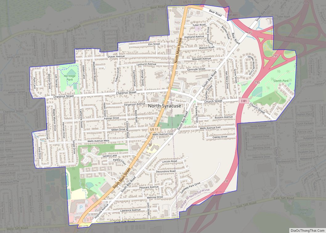
North Syracuse is a village in Onondaga County, New York, United States. As of the 2020 census, the population was 6,739. North Syracuse is located in the towns of Cicero and Clay, north of the city of Syracuse. North Syracuse village overview: Name: North Syracuse village LSAD Code: 47 LSAD Description: village (suffix) State: New ... Read more
Map of North Syracuse village
Map of Northwest Ithaca CDP
Northwest Ithaca is a census-designated place (CDP) in Tompkins County, New York, United States. The population was 1,115 at the 2000 census. Northwest Ithaca CDP overview: Name: Northwest Ithaca CDP LSAD Code: 57 LSAD Description: CDP (suffix) State: New York County: Tompkins County Total Area: 3.56 sq mi (9.22 km²) Land Area: 3.55 sq mi (9.20 km²) Water Area: 0.01 sq mi (0.01 km²) ... Read more
Map of Northwest Ithaca CDP
Map of Northwest Harbor CDP
Northwest Harbor is a hamlet and census-designated place (CDP) in the Town of East Hampton, Suffolk County, New York, United States. The population was 3,317 at the 2010 census. It is named for the bay on the South Fork of Long Island connecting Sag Harbor, Shelter Island and the town of East Hampton to Gardiners ... Read more
Map of Northwest Harbor CDP
Map of Northville CDP, New York
Northville is a hamlet and census-designated place (CDP) in the Town of Riverhead in Suffolk County, on Long Island, in New York, United States. The CDP population was 1,340 at the 2010 census. Between 1921 and 1930, it was an incorporated village known originally as the Incorporated Village of Sound Avenue, and from 1927 to ... Read more
Map of Northville CDP, New York
Map of Northport village, New York
Northport is a historic maritime village on the northern shore of Long Island in Suffolk County, New York, United States. Initially designated Great Cow Harbour by 17th-century English colonists, the area was officially renamed Northport in 1837. In 1894, in an effort to localize governance, the community was incorporated as a village. Northport is known ... Read more
Map of Northport village, New York
Map of Northeast Ithaca CDP
Northeast Ithaca is a census-designated place (CDP) in Ithaca (town), New York in Tompkins County, New York, United States. The population was 2,655 at the 2000 census. Northeast Ithaca is a suburb of adjacent Ithaca, New York. Northeast Ithaca CDP overview: Name: Northeast Ithaca CDP LSAD Code: 57 LSAD Description: CDP (suffix) State: New York ... Read more
Map of Northeast Ithaca CDP
Map of Northampton CDP, New York
Northampton (/ˈnɔːrθæmptən, ˈnɔːrð-/) is a hamlet and census-designated place (CDP) in Suffolk County, New York, United States on Long Island. The CDP population was 570 at the 2010 census. Northampton is in the Town of Southampton. The Eastern Campus of Suffolk County Community College is located in Northampton. Northampton CDP overview: Name: Northampton CDP LSAD ... Read more
Map of Northampton CDP, New York
Map of North Wantagh CDP
North Wantagh is a hamlet and census-designated place in the Town of Hempstead in Nassau County, on the South Shore of Long Island, in New York, United States. The population was 11,960 at the 2010 census. North Wantagh CDP overview: Name: North Wantagh CDP LSAD Code: 57 LSAD Description: CDP (suffix) State: New York County: ... Read more
Map of North Wantagh CDP
Map of North Valley Stream CDP
North Valley Stream is a hamlet and census-designated place (CDP) in the Town of Hempstead in Nassau County, on Long Island, in New York, United States. The population was 16,628 at the 2010 census. North Valley Stream CDP overview: Name: North Valley Stream CDP LSAD Code: 57 LSAD Description: CDP (suffix) State: New York County: ... Read more
Map of North Valley Stream CDP
Map of Oakfield village, New York
Oakfield is a village in Genesee County, New York, United States. As of the 2010 census, the village population was 1,813. The village lies within the town of Oakfield in northern Genesee County. The village is at the intersection of Route 63 (Lewiston Road) and Route 262. It is northwest of Batavia. Oakfield village overview: ... Read more
Map of Oakfield village, New York
Map of Oakdale CDP, New York
Oakdale is a hamlet (and census-designated place) in Suffolk County, New York, United States. The population was 7,974 at the 2010 census. Oakdale is in the Town of Islip. It has been home to Gilded Age mansions, the South Side Sportsmen’s Club, and the main campus of Dowling College. It is now home to Connetquot ... Read more
Map of Oakdale CDP, New York
Map of Oak Beach-Captree CDP
Oak Beach-Captree CDP overview: Name: Oak Beach-Captree CDP LSAD Code: 57 LSAD Description: CDP (suffix) State: New York County: Suffolk County FIPS code: 3654112 Online Interactive Map Oak Beach-Captree online map. Source: Basemap layers from Google Map, Open Street Map (OSM), Arcgisonline, Wmflabs. Boundary Data from Database of Global Administrative Areas. Oak Beach-Captree location map. ... Read more
Map of Oak Beach-Captree CDP