Map of Ravena village
Ravena is a village in Albany County, New York, United States. The population was 3,271 in the 2020 census an increase of 3 over the 2010 census. The village is in the southeast part of the town of Coeymans. Ravena village overview: Name: Ravena village LSAD Code: 47 LSAD Description: village (suffix) State: New York ... Read more
Map of Ravena village
Map of Rensselaer city, New York
Rensselaer /rɛnsəˈlɪər/ is a city in Rensselaer County, New York, United States, and is located on the east side of the Hudson River, directly opposite of Albany. As of the 2020 census, the city population was 9,210. Rensselaer is on the western border of Rensselaer County. The area now known as the City of Rensselaer ... Read more
Map of Rensselaer city, New York
Map of Rensselaer Falls village
Rensselaer Falls is a village located in St. Lawrence County, New York. As of the 2010 census, the village had a total population of 332. The current name came from mill owner Henry Van Rensselaer. The Village of Rensselaer Falls is in the western part of the Town of Canton and is due west of ... Read more
Map of Rensselaer Falls village
Map of Remsenburg-Speonk CDP
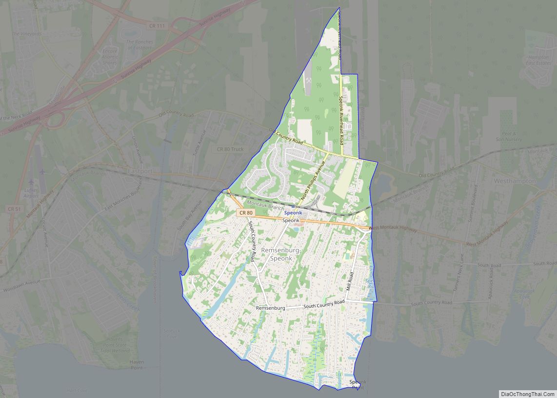
Remsenburg-Speonk is a census-designated place (CDP) located in the Town of Southampton, Suffolk County, New York, United States. It consists of the hamlets of Remsenburg and Speonk. The population was 2,642 at the 2010 census. The population of this CDP and surrounding ones increases in the summer due to summer renters who come out for ... Read more
Map of Remsenburg-Speonk CDP
Map of Remsen village, New York
Remsen is a village in Oneida County, New York, United States. The population was 508 at the 2010 census. The Village of Remsen is in the southwestern part of the Town of Remsen. The Remsen Barn Festival of the Arts (FOTA) is held in late September. The first Barn Festival was in 1980. Thousands of ... Read more
Map of Remsen village, New York
Map of Redwood CDP, New York
Redwood is a hamlet and census-designated place (CDP) in Jefferson County, New York, United States. As of the 2010 census, the population was 605. Redwood CDP overview: Name: Redwood CDP LSAD Code: 57 LSAD Description: CDP (suffix) State: New York County: Jefferson County Elevation: 367 ft (112 m) Total Area: 2.48 sq mi (6.43 km²) Land Area: 1.97 sq mi (5.10 km²) Water ... Read more
Map of Redwood CDP, New York
Map of Redford CDP, New York
Redford is a hamlet and census-designated place in the town of Saranac in Clinton County, New York, United States. The population was 477 at the 2010 census. Redford is in the southern part of the town and is west of Plattsburgh. It is within the Adirondack Park. Redford CDP overview: Name: Redford CDP LSAD Code: ... Read more
Map of Redford CDP, New York
Map of Ripley CDP, New York
Ripley is a census-designated place (CDP) in the town of Ripley in Chautauqua County, New York, United States. As of the 2010 census, the population of the CDP was 872, out of a total town population of 2,415. Ripley is located on U.S. Route 20 and Interstate 90 in the northeast corner of the town. ... Read more
Map of Ripley CDP, New York
Map of Rifton CDP
Rifton is a hamlet (and census-designated place) in Ulster County, New York, United States. The population was 481 at the 2020 census. Rifton is home to the Woodcrest Bruderhof and is located near the western town line of the Town of Esopus on Route 213. Rifton CDP overview: Name: Rifton CDP LSAD Code: 57 LSAD ... Read more
Map of Rifton CDP
Map of Ridge CDP
Ridge is a hamlet and census-designated place (CDP) in the town of Brookhaven, Suffolk County, New York, United States. The population was 13,336 at the 2010 census. Ridge CDP overview: Name: Ridge CDP LSAD Code: 57 LSAD Description: CDP (suffix) State: New York County: Suffolk County Elevation: 92 ft (28 m) Total Area: 13.29 sq mi (34.41 km²) Land Area: ... Read more
Map of Ridge CDP
Map of Richville village, New York
Richville is a village in St. Lawrence County, New York, United States. The population was 323 at the 2010 census. The name is taken from an early settler. The Village of Richville is in the southwestern corner of the Town of De Kalb and is southwest of the Village of Canton. Richville village overview: Name: ... Read more
Map of Richville village, New York
Map of Richmondville village
Richmondville is a village in Schoharie County, New York, United States. The population was 918 at the 2010 census. The Village of Richmondville is in the center of the Town of Richmondville and is northeast of Oneonta. Richmondville village overview: Name: Richmondville village LSAD Code: 47 LSAD Description: village (suffix) State: New York County: Schoharie ... Read more
Map of Richmondville village