Map of Richfield Springs village
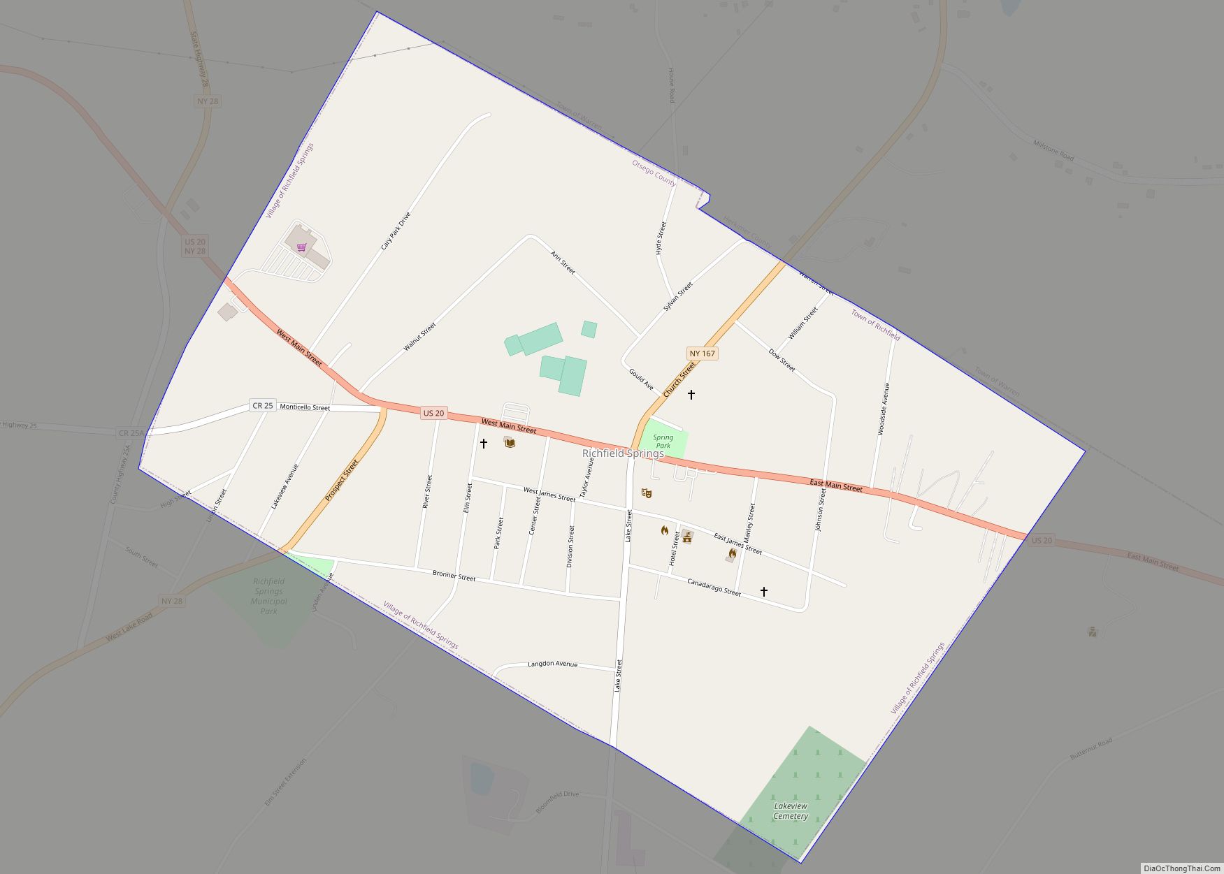
Richfield Springs is a village located in the Town of Richfield, on the north-central border of Otsego County, New York, United States. The population was 1,264 at the 2010 census. The name is derived from local sulfur springs. Richfield Springs village overview: Name: Richfield Springs village LSAD Code: 47 LSAD Description: village (suffix) State: New ... Read more
Map of Richfield Springs village
Map of Richburg village, New York
Richburg is a village in Allegany County, New York, United States. The population was 450 at the 2010 census. The village is partly within the boundaries of the towns of Wirt and Bolivar. The community is east of Olean. Richburg village overview: Name: Richburg village LSAD Code: 47 LSAD Description: village (suffix) State: New York ... Read more
Map of Richburg village, New York
Map of Rhinecliff CDP
Rhinecliff is a hamlet and census-designated place (CDP) located along the Hudson River in the town of Rhinebeck in northern Dutchess County, New York, United States. As of the 2010 census, the population of Rhinecliff was 425. Rhinecliff CDP overview: Name: Rhinecliff CDP LSAD Code: 57 LSAD Description: CDP (suffix) State: New York County: Dutchess ... Read more
Map of Rhinecliff CDP
Map of Rhinebeck village
Rhinebeck is a village in the town of Rhinebeck in Dutchess County, New York, United States. The population was 2,657 at the 2010 census. It is part of the Poughkeepsie–Newburgh–Middletown, NY Metropolitan Statistical Area as well as the larger New York–Newark–Connecticut. The postal ZIP code is 12572. U.S. Route 9 passes through the village. Rhinebeck ... Read more
Map of Rhinebeck village
Map of Retsof CDP
Retsof is a hamlet and census-designated place (CDP) within the town of York in Livingston County, New York, United States. The community, situated 30 miles (48 km) southwest of the city of Rochester, is off New York State Route 63 approximately one mile east of State Route 36. As of the 2010 census, it had a ... Read more
Map of Retsof CDP
Map of Rockville Centre village
Rockville Centre, commonly abbreviated as RVC, is an incorporated village located in the Town of Hempstead in Nassau County, on the South Shore of Long Island, in New York, United States. The population was 26,016 at the 2020 census. Rockville Centre village overview: Name: Rockville Centre village LSAD Code: 47 LSAD Description: village (suffix) State: ... Read more
Map of Rockville Centre village
Map of Rock Hill CDP, New York
Rock Hill is a hamlet (and census-designated place) in Sullivan County, New York, United States. At the 2010 census the population was 1,742. Rock Hill is in the town of Thompson by New York State Route 17. Rock Hill CDP overview: Name: Rock Hill CDP LSAD Code: 57 LSAD Description: CDP (suffix) State: New York ... Read more
Map of Rock Hill CDP, New York
Map of Riverside CDP, New York
Riverside is a hamlet and census-designated place (CDP) in Suffolk County, New York, United States. The population was 2,911 at the 2010 census. Riverside is in the Town of Southampton and derives its name from being on the south bank of the Peconic River. Riverside CDP overview: Name: Riverside CDP LSAD Code: 57 LSAD Description: ... Read more
Map of Riverside CDP, New York
Map of Riverhead CDP
Riverhead is a census-designated place (CDP) roughly corresponding to the hamlet by the same name located in the Town of Riverhead in Suffolk County, on Long Island, in New York, United States. The CDP’s population was 13,299 at the 2010 census. Situated at the mouth of the Peconic River, which empties into Peconic Bay where ... Read more
Map of Riverhead CDP
Map of Roosevelt CDP, New York
Roosevelt (historically known as Greenwich and Rum Point) is a hamlet and census-designated place (CDP) in the Town of Hempstead in Nassau County, on the South Shore of Long Island, in New York, United States. The population was 18,066 at the 2020 census. Roosevelt CDP overview: Name: Roosevelt CDP LSAD Code: 57 LSAD Description: CDP ... Read more
Map of Roosevelt CDP, New York
Map of Ronkonkoma CDP
Ronkonkoma (/rɒnˈkɒŋkəmə/ ron-KONG-kə-mə) is a hamlet and census-designated place (CDP) in the Town of Islip in Suffolk County, on Long Island, in New York, United States. The population was 19,082 at the 2010 census. The Ronkonkoma post office has the ZIP Code 11779, and serves parts of several hamlets and CDPs adjacent to Ronkonkoma. Ronkonkoma ... Read more
Map of Ronkonkoma CDP
Map of Romulus CDP, New York
Romulus is a hamlet (and census-designated place) located in the Town of Romulus, Seneca County, New York, United States on the border with the Town of Varick. The population was 409 at the 2010 census. The hamlet was originally called “Romulusville.” It was renamed Romulus, after the town, circa 1870. Romulus CDP overview: Name: Romulus ... Read more
Map of Romulus CDP, New York