Map of Sand Ridge CDP

Map of Sand Ridge CDP

Sand Ridge is a hamlet (and census-designated place) in Oswego County, New York, United States. The population was 849 at the 2010 census. Sand Ridge is in the southern section of the Town of Schroeppel. Sand Ridge CDP overview: Name: Sand Ridge CDP LSAD Code: 57 LSAD Description: CDP (suffix) State: New York County: Oswego … Read more

Map of Sanborn CDP, New York

Map of Sanborn CDP, New York

Sanborn is a hamlet (and census-designated place, population: 1,645 in 2010 census) in the Towns of Cambria, Lewiston, and Wheatfield, in Niagara County, New York, United States, on the southern side of the intersection of New York State Route 429 and New York State Route 31. Originally called South Pekin after the formerly thriving hamlet … Read more

Map of Saltaire village

Map of Saltaire village

Saltaire is a village located on Fire Island in Islip, Suffolk County, New York, United States. The year-round population was 37 at the 2010 census, which, as a summer beach community, increases many times over in the summer. Saltaire village overview: Name: Saltaire village LSAD Code: 47 LSAD Description: village (suffix) State: New York County: … Read more

Map of Salt Point CDP

Map of Salt Point CDP

Salt Point is a hamlet and census-designated place (CDP) located in the Town of Pleasant Valley, Dutchess County, New York, United States. As of the 2020 census it had a population of 202. It lies northeast of Poughkeepsie following New York Route 115, the Salt Point Turnpike. East of Salt Point, the Taconic State Parkway … Read more

Map of Salisbury CDP, New York

Map of Salisbury CDP, New York

Salisbury (formerly known as South Westbury) is a hamlet and census-designated place (CDP) in the Town of Hempstead in Nassau County, on Long Island, in New York, United States. The population was 12,093 at the 2010 census. Many Levitt style homes lie adjacent to Eisenhower Park (formerly known as Salisbury Park). It is served by … Read more

Map of Salisbury Mills CDP

Map of Salisbury Mills CDP

Salisbury Mills is a hamlet and census-designated place (CDP) in the towns of Blooming Grove and Cornwall in Orange County, New York, United States. As of the 2020 census, it had a population of 580. The CDP is in eastern Orange County and is bordered to the north by Beaver Dam Lake. Salisbury Mills is … Read more

Map of Salem CDP, New York

Map of Salem CDP, New York

Salem is a hamlet (and census-designated place) located in the town of Salem in Washington County, New York, United States. It is part of the Glens Falls Metropolitan Statistical Area. The population was 946 at the 2010 census. The hamlet is located in the north central part of Town of Salem, at the junction of … Read more

Map of Saranac Lake village

Map of Saranac Lake village

Saranac Lake is a village in the state of New York, United States. As of the 2020 census, the population was 4,887, making it the largest community by population in the Adirondack Park. The village is named after Upper, Middle and Lower Saranac lakes, which are nearby. The village of Saranac Lake covers parts of … Read more

Map of Sandy Creek village, New York

Map of Sandy Creek village, New York

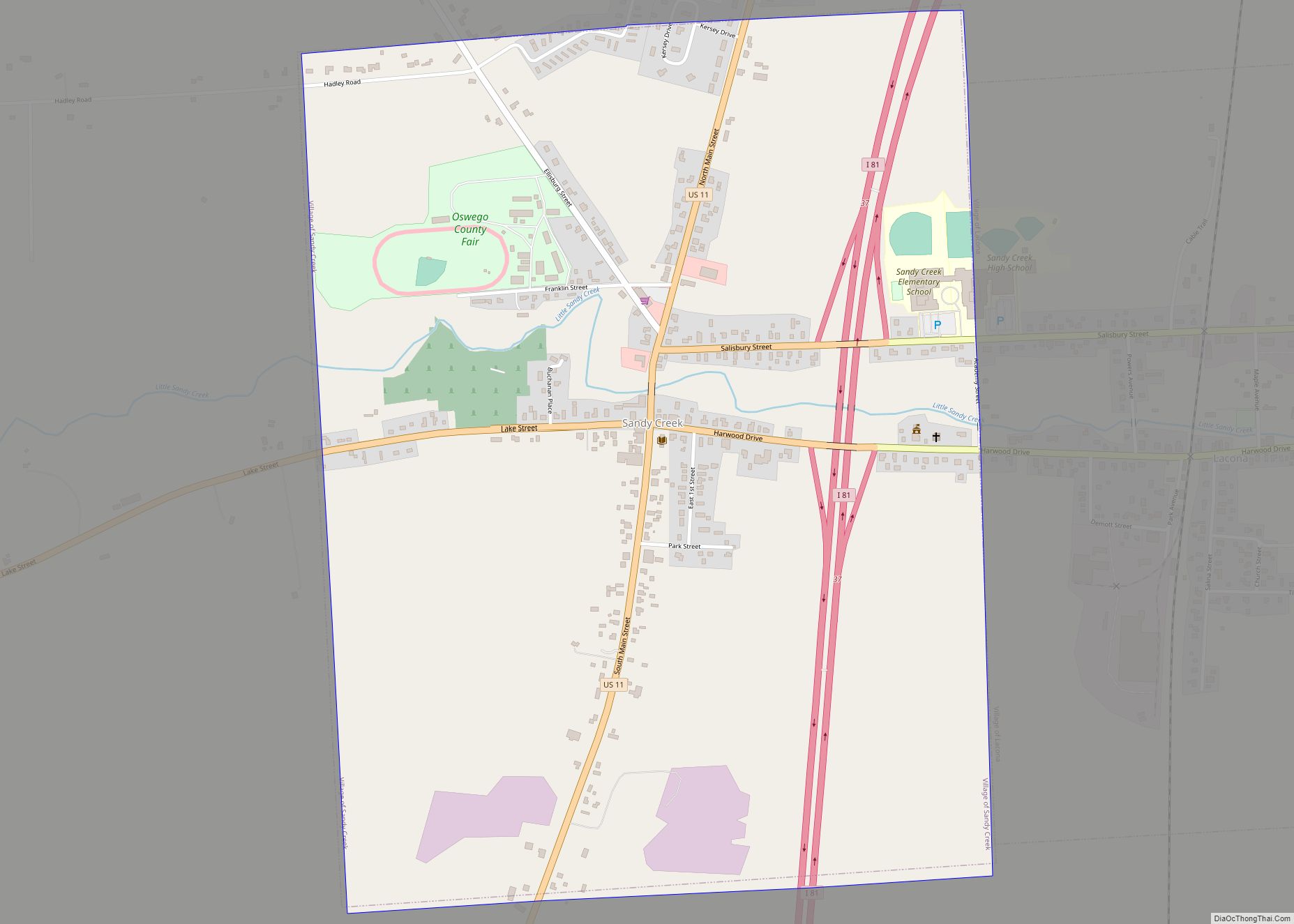
Sandy Creek is a village in Oswego County, New York, United States. The population was 771 at the 2010 census. The Village of Sandy Creek in the central part of the Town of Sandy Creek. The village is located by U.S. Route 11. Sandy Creek village overview: Name: Sandy Creek village LSAD Code: 47 LSAD … Read more

Map of Schenevus CDP

Map of Schenevus CDP

Schenevus is a hamlet (and census-designated place) in the town of Maryland in southeastern Otsego County, New York, United States. According to the 2010 census, the population was 551. The Schenevus Central School district covers the towns of Maryland, Westford, Milford, Decatur and Roseboom. The Schenevus Carousel and Twentieth Century Steam Riding Gallery No. 409 … Read more

Map of Schenectady city

Map of Schenectady city

Schenectady (/skəˈnɛktədi/) is a city in Schenectady County, New York, United States, of which it is the county seat. As of the 2020 census, the city’s population of 67,047 made it the state’s ninth-largest city by population. The city is in eastern New York, near the confluence of the Mohawk and Hudson rivers. It is … Read more

Map of Schaghticoke village

Map of Schaghticoke village

Schaghticoke is a village in Rensselaer County, New York, United States. The population was 592 at the 2010 census. During the colonial period of 1640-1750, this area was occupied by a mixed group of Native Americans — Mohicans, who were local, and remnants of numerous New England tribes who had migrated west away from European … Read more