Map of Bergen village, New York

Map of Bergen village, New York

Bergen (/ˈbɜːrdʒən/ BUR-jən) is a village in Genesee County, New York, United States. The population was 1,176 at the 2010 census. The village lies on the eastern edge of the town of Bergen. The village is north of the junction of Routes 19 and 33. Bergen village overview: Name: Bergen village LSAD Code: 47 LSAD … Read more

Map of Bemus Point village

Map of Bemus Point village

Bemus Point is a village in Chautauqua County, New York, United States. The village is within the town of Ellery and is located along the eastern shore of Chautauqua Lake. The population was 312 at the 2020 census. Bemus Point village overview: Name: Bemus Point village LSAD Code: 47 LSAD Description: village (suffix) State: New … Read more

Map of Belmont village, New York

Map of Belmont village, New York

Belmont is a village within the town of Amity in Allegany County, New York, United States. Belmont is the county seat of Allegany County. The population was 969 at the 2010 census. The name means “beautiful hill”. The village is centrally located in Amity and is northeast of Olean. Belmont village overview: Name: Belmont village … Read more

Map of Bellport village

Map of Bellport village

Bellport is a village in the Town of Brookhaven in Suffolk County, on the South Shore of Long Island, in New York, United States. The population was 2,084 at the 2010 census. The Incorporated Village of Bellport is named after the Bell family, early settlers of the area. South Country Road (Main St.) in the … Read more

Map of Bellmore CDP

Map of Bellmore CDP

Bellmore is a hamlet and census-designated place (CDP) in Nassau County, New York, United States. The population according to the 2010 census was 16,218. Bellmore is located on the south shore of Long Island 5 miles from Jones Beach State Park, approximately 27 miles (43 km) east of Manhattan, and 10 miles (16 km) east of the … Read more

Map of Binghamton city

Map of Binghamton city

Binghamton (/ˈbɪŋəmtən/ BING-əm-tən) is a city in the U.S. state of New York, and serves as the county seat of Broome County. Surrounded by rolling hills, it lies in the state’s Southern Tier region near the Pennsylvania border, in a bowl-shaped valley at the confluence of the Susquehanna and Chenango Rivers. Binghamton is the principal … Read more

Map of Binghamton University CDP

Map of Binghamton University CDP

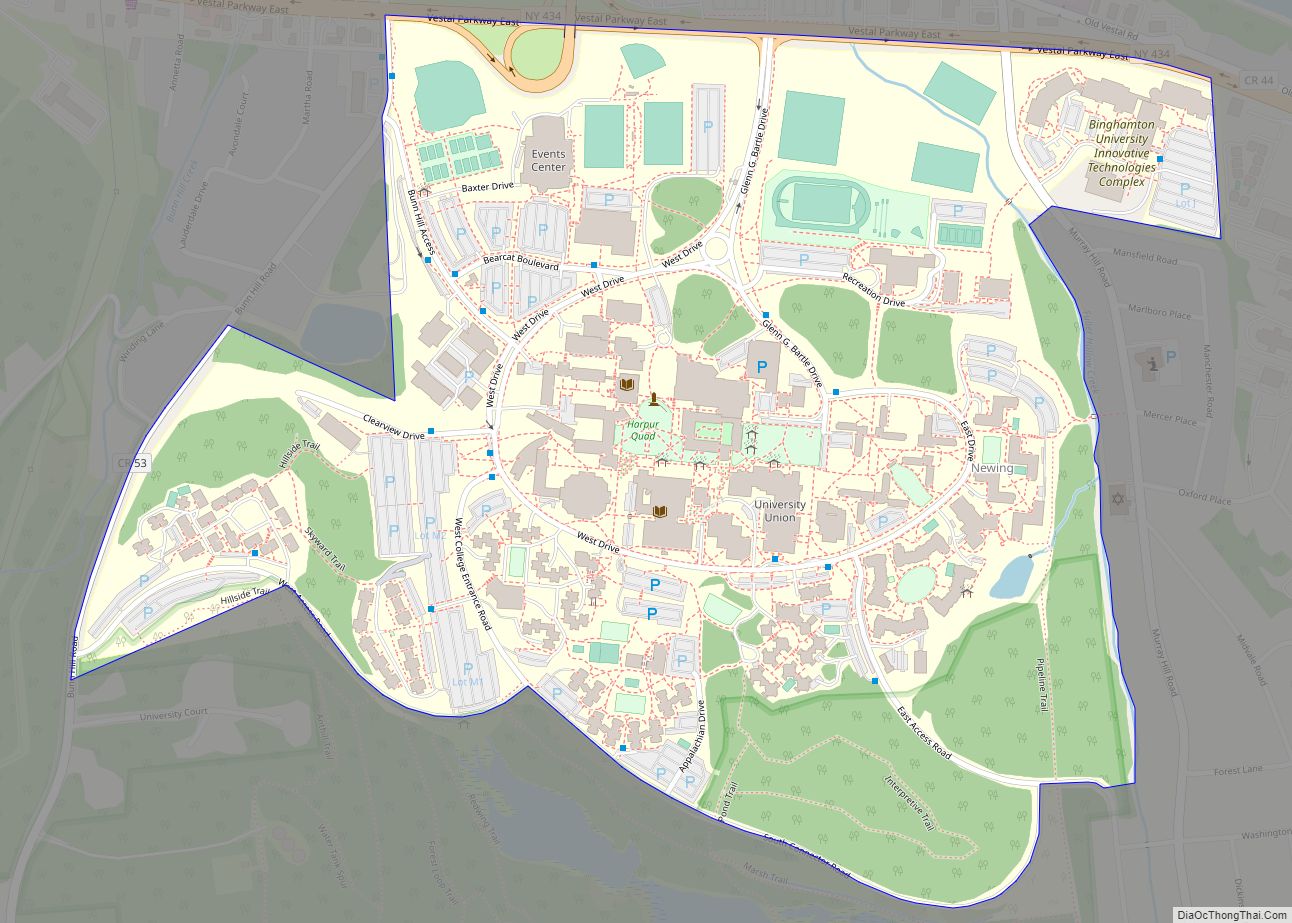
Binghamton University CDP is a census-designated place (CDP) covering the Binghamton University campus in Broome County, New York, United States. It covers the permanent resident population of the campus and is not reflective of either the student body or include students who list their permanent residency elsewhere. Per the 2020 census, the population was 7,261. … Read more

Map of Billington Heights CDP

Map of Billington Heights CDP

Billington Heights is a hamlet and census-designated place (CDP) in the towns of Elma and Aurora in Erie County, New York, United States. The population was 1,685 at the 2010 census. It is part of the Buffalo–Niagara Falls Metropolitan Statistical Area. Billington Heights CDP overview: Name: Billington Heights CDP LSAD Code: 57 LSAD Description: CDP … Read more

Map of Big Flats CDP

Map of Big Flats CDP

Big Flats is an unincorporated community and census-designated place (CDP) within the town of Big Flats in Chemung County, New York, United States. The population of the CDP was 5,277 at the 2010 census, out of a total population in the town of 7,595. Big Flats CDP overview: Name: Big Flats CDP LSAD Code: 57 … Read more

Map of Bohemia CDP

Map of Bohemia CDP

Bohemia /boʊhiːmiːə/ is a hamlet (and census-designated place) in Suffolk County, New York, United States. The population was 10,180 at the 2010 census. It is situated along the South Shore of Long Island in the Town of Islip, approximately 50 miles from New York City. A portion of Long Island MacArthur Airport is located within … Read more

Map of Blue Point CDP

Map of Blue Point CDP

Blue Point is a hamlet and census-designated place in Suffolk County on Long Island, New York, United States. The population was 5,156 at the 2020 census. Blue Point is in the Town of Brookhaven. Blue Point CDP overview: Name: Blue Point CDP LSAD Code: 57 LSAD Description: CDP (suffix) State: New York County: Suffolk County … Read more

Map of Bloomville CDP

Map of Bloomville CDP, New York

Bloomville is a hamlet and census-designated place (CDP) in the town of Kortright, Delaware County, New York, United States. The population was 213 at the 2010 census. Bloomville CDP overview: Name: Bloomville CDP LSAD Code: 57 LSAD Description: CDP (suffix) State: New York County: Delaware County Elevation: 1,455 ft (443 m) Total Area: 1.32 sq mi (3.43 km²) Land Area: … Read more