Map of Scottsburg CDP, New York
Scottsburg is a hamlet and census-designated place (CDP) in Livingston County, New York, United States. Its population was 117 as of the 2010 census. New York State Route 256 passes through the community. Scottsburg CDP overview: Name: Scottsburg CDP LSAD Code: 57 LSAD Description: CDP (suffix) State: New York County: Livingston County Elevation: 925 ft (282 m) ... Read more
Map of Scottsburg CDP, New York
Map of Scotts Corners CDP
Scotts Corners is a hamlet (and census-designated place or CDP) located in the town of Pound Ridge in Westchester County, New York, United States. As of the 2010 census, the CDP population was 711, making Scotts Corners Westchester County’s smallest census-recognized area. Scotts Corners is near the southern town line (the border of Connecticut), east ... Read more
Map of Scotts Corners CDP
Map of Scotia village, New York
Scotia is a village in Schenectady County, New York, United States, incorporated in 1904. The population was 7,729 at the 2010 census. Scotia is part of the town of Glenville, and is connected with the city of Schenectady by the Western Gateway Bridge over the Mohawk River. Scotia village overview: Name: Scotia village LSAD Code: ... Read more
Map of Scotia village, New York
Map of Scotchtown CDP
Scotchtown is a hamlet (and census-designated place) in the Town of Wallkill, in Orange County, New York, United States. The population was 10,578 at the 2020 census. It has the ZIP Code 10941. The hamlet is located east of the City of Middletown. It is part of the Poughkeepsie–Newburgh–Middletown, NY Metropolitan Statistical Area as well ... Read more
Map of Scotchtown CDP
Map of Scio CDP, New York
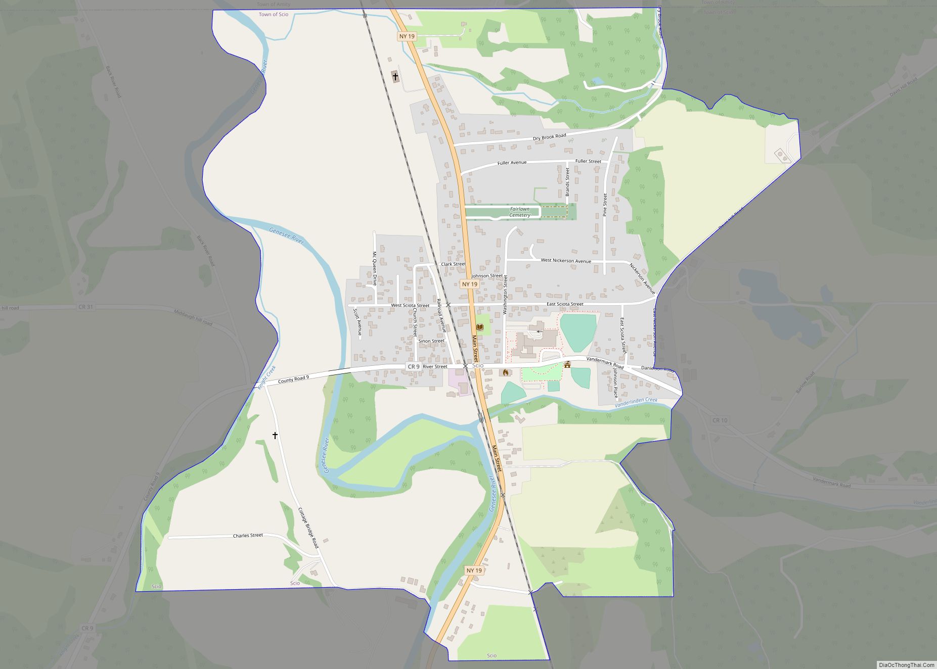
Scio is a census-designated place comprising the primary settlement in the town of Scio, Allegany County, New York, United States. As of the 2010 census it had a population of 609, out of a total population of 1,833 in the town. Scio CDP overview: Name: Scio CDP LSAD Code: 57 LSAD Description: CDP (suffix) State: ... Read more
Map of Scio CDP, New York
Map of Shelter Island CDP
Shelter Island is a hamlet and census-designated place (CDP) within the Town of Shelter Island in Suffolk County, New York, United States. The population was 1,333 at the 2010 census. The village of Dering Harbor and the CDP of Shelter Island Heights make up the rest of the town. The community of Shelter Island is ... Read more
Map of Shelter Island CDP
Map of Shelter Island Heights CDP
Shelter Island Heights is a hamlet and census-designated place (CDP) located in the Town of Shelter Island, Suffolk County, New York, United States. It is located on the north side of the island of Shelter Island, surrounding the village of Dering Harbor. The population was 1,048 at the 2010 census. Shelter Island Heights CDP overview: ... Read more
Map of Shelter Island Heights CDP
Map of Sharon Springs village, New York
Sharon Springs is a village in Schoharie County, New York, United States. The population was 558 at the 2010 census. Its name derives from the hometown of the first Colonial settlers, Sharon, Connecticut, and the important springs in the village. Sharon Springs, Kansas likewise was settled by former residents of this Upstate New York village. ... Read more
Map of Sharon Springs village, New York
Map of Setauket-East Setauket CDP
Setauket-East Setauket CDP overview: Name: Setauket-East Setauket CDP LSAD Code: 57 LSAD Description: CDP (suffix) State: New York County: Suffolk County FIPS code: 3666481 Online Interactive Map Setauket-East Setauket online map. Source: Basemap layers from Google Map, Open Street Map (OSM), Arcgisonline, Wmflabs. Boundary Data from Database of Global Administrative Areas. Setauket-East Setauket location map. ... Read more
Map of Setauket-East Setauket CDP
Map of Seneca Knolls CDP
Seneca Knolls is a hamlet (and census-designated place) in Onondaga County, New York, United States. The population was 2,011 at the 2010 census. Seneca Knolls is in the eastern part of the town of Van Buren. Seneca Knolls CDP overview: Name: Seneca Knolls CDP LSAD Code: 57 LSAD Description: CDP (suffix) State: New York County: ... Read more
Map of Seneca Knolls CDP
Map of Seneca Falls CDP
Seneca Falls is a hamlet and census-designated place in Seneca County, New York, United States. The population was 6,681 at the 2010 census. The 2020 census population of Seneca Falls CDP was 6,809. The hamlet is in the Town of Seneca Falls, east of Geneva. It was an incorporated village from 1831 to 2011. Finger ... Read more
Map of Seneca Falls CDP
Map of Selden CDP, New York
Selden is a hamlet (and census-designated place) in the Town of Brookhaven in Suffolk County, New York, United States. The population was 19,851 at the 2010 census. Selden CDP overview: Name: Selden CDP LSAD Code: 57 LSAD Description: CDP (suffix) State: New York County: Suffolk County Elevation: 89 ft (27 m) Total Area: 4.55 sq mi (11.78 km²) Land Area: ... Read more
Map of Selden CDP, New York