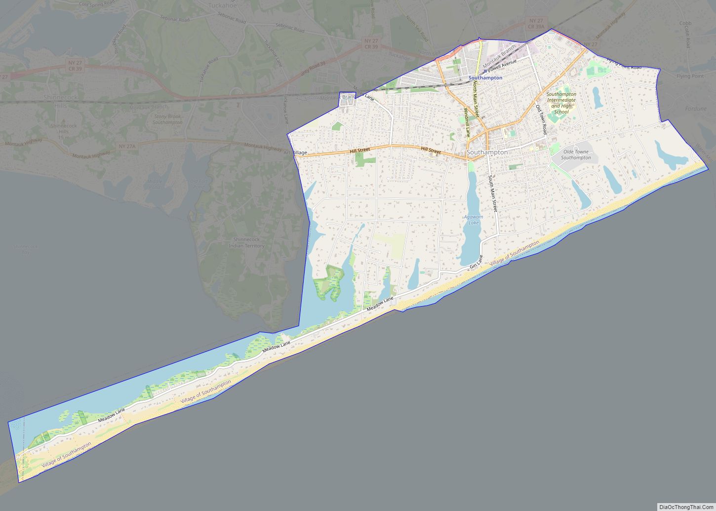
Map of South Lockport CDP
South Lockport is a hamlet (and census-designated place) located in the Town of Lockport in Niagara County, New York, United States. The population was 8,234 at the 2010 census. It is part of the Buffalo–Niagara Falls Metropolitan Statistical Area. South Lockport is south of the City of Lockport on New York State Route 78. South ... Read more
Map of South Lockport CDP
Map of South Lima CDP
South Lima is a hamlet and census-designated place (CDP) in Livingston County, New York, United States. Its population was 240 as of the 2010 census. South Lima had a post office from January 10, 1854, until April 17, 2010; it still has its own ZIP code, 14558. South Lima CDP overview: Name: South Lima CDP ... Read more
Map of South Lima CDP
Map of South Huntington CDP
South Huntington is an affluent hamlet and census-designated place (CDP) within the Town of Huntington in Suffolk County, on Long Island, in New York, United States. The population was 9,422 at the 2010 census. Residents have a Huntington Station postal address. South Huntington is the birthplace of Walt Whitman, and the Walt Whitman Shops Mall ... Read more
Map of South Huntington CDP
Map of South Hill CDP, New York
South Hill is a census-designated place (CDP) in Tompkins County, New York, United States. The population was 7,245 at the 2020 census. The South Hill CDP is located within the town of Ithaca. It is located near the south end of Cayuga Lake. The name South Hill is shared with a contiguous area within the ... Read more
Map of South Hill CDP, New York
Map of South Hempstead CDP
South Hempstead is a hamlet and census-designated place (CDP) in the Town of Hempstead in Nassau County, on Long Island, in New York, United States. The population was 3,243 at the 2010 census. South Hempstead CDP overview: Name: South Hempstead CDP LSAD Code: 57 LSAD Description: CDP (suffix) State: New York County: Nassau County Elevation: ... Read more
Map of South Hempstead CDP
Map of South Glens Falls village
South Glens Falls is a village in Saratoga County, New York, United States. The population was 3,518 at the 2010 census. The village is in the northern part of the Town of Moreau, south of the City of Glens Falls. Cooper’s Cave, shown on the village seal, is named after the author, James Fenimore Cooper. ... Read more
Map of South Glens Falls village
Map of South Floral Park village
South Floral Park (formerly known as Jamaica Square) is a village in the Town of Hempstead in Nassau County, on Long Island, in New York, United States. The population was 1,741 at the 2020 census. At 0.096 square miles (0.25 km), the Incorporated Village of South Floral Park is the smallest village in the State of ... Read more
Map of South Floral Park village
Map of Spackenkill CDP
Spackenkill (/ˈspækənˌkɪl/) is a hamlet and census-designated place (CDP) in Dutchess County, New York, United States. The population was 4,123 at the 2010 census. It is part of the Poughkeepsie–Newburgh–Middletown, NY Metropolitan Statistical Area as well as the larger New York–Newark–Bridgeport, NY-NJ–CT–PA Combined Statistical Area. Spackenkill is in the town of Poughkeepsie. Children in the ... Read more
Map of Spackenkill CDP
Map of Southport CDP, New York
Southport is a census-designated place (CDP) in the town of Southport in Chemung County, New York, United States. The population of the CDP was 7,238 at the 2010 census, out of a total population in the town of 10,940. Southport CDP overview: Name: Southport CDP LSAD Code: 57 LSAD Description: CDP (suffix) State: New York ... Read more
Map of Southport CDP, New York
Map of Southold CDP
Southold is a census-designated place (CDP) that generally corresponds to the hamlet by the same name in the Town of Southold in Suffolk County, New York, United States. The CDP population was 5,748 at the 2010 census. Southold CDP overview: Name: Southold CDP LSAD Code: 57 LSAD Description: CDP (suffix) State: New York County: Suffolk ... Read more
Map of Southold CDP
Map of Springville village, New York
Springville is a village in the southeastern section of the town of Concord in Erie County, New York, United States. Springville is the principal community in the town and a major business location in southern Erie County. The population was 4,296 at the 2010 census. It is part of the Buffalo–Niagara Falls Metropolitan Statistical Area. ... Read more
Map of Springville village, New York
Map of Springs CDP
Springs is a census-designated place (CDP) roughly corresponding to the hamlet by the same name in the Town of East Hampton in Suffolk County, New York, United States, on the South Fork of Long Island. As of the 2010 United States Census, the CDP population was 6,592. Springs CDP overview: Name: Springs CDP LSAD Code: ... Read more
Map of Springs CDP