Map of Wilson village, New York
Wilson is a town in Niagara County, New York, United States. The population was 5,993 at the 2010 census. The town was named after an early settler, Reuben Wilson, who built and dwelt in a log cabin on the shore of Lake Ontario at the site of what would become the Village of Wilson. The ... Read more
Map of Wilson village, New York
Map of Woodsburgh village
Woodsburgh is a village in the Town of Hempstead in Nassau County, on the South Shore of Long Island, in New York, United States. The population was 778 at the 2010 United States Census. Woodsburgh is included in the Five Towns (though not as one of the “five”), which is usually said to comprise the ... Read more
Map of Woodsburgh village
Map of Woodridge village, New York
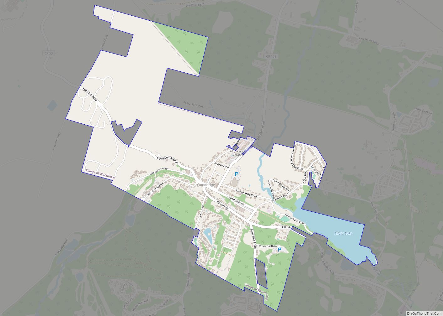
Woodridge is a village in Sullivan County, New York, United States. The population was 847 at the 2010 census. The village is in the town of Fallsburg at the junction of county routes 53, 54, 58, and 158. The Woodridge ZIP Code is 12789. Woodridge village overview: Name: Woodridge village LSAD Code: 47 LSAD Description: ... Read more
Map of Woodridge village, New York
Map of Woodmere CDP, New York
Woodmere is a hamlet and census-designated place (CDP) in the Town of Hempstead in Nassau County, New York, United States. The population was 17,554 at the 2016 census. Woodmere is one of the Long Island communities known as the Five Towns, which is usually said to comprise the villages of Lawrence and Cedarhurst, the hamlets ... Read more
Map of Woodmere CDP, New York
Map of Woodbury CDP, New York
Woodbury is a hamlet and census-designated place (CDP) located within the Town of Oyster Bay in Nassau County, on Long Island, in New York, United States. The population was 8,907 at the 2010 census. Woodbury borders Laurel Hollow to the north, Plainview to the south, Syosset to the west, and Cold Spring Harbor, West Hills ... Read more
Map of Woodbury CDP, New York
Map of Wolcott village, New York
Wolcott is a village in Wayne County, New York, United States. The population was 1,701 at the 2010 census. The name is from Oliver Wolcott, a former governor of Connecticut. The Village of Wolcott is in the southwest part of the Town of Wolcott and is west of Syracuse, New York. Part of the southward ... Read more
Map of Wolcott village, New York
Map of Witherbee CDP
Witherbee is a hamlet and census-designated place (CDP) in the town of Moriah in Essex County, New York, United States. The population of the CDP was 347 at the 2010 census. Prior to 2010 the hamlet was part of the Mineville-Witherbee CDP. Witherbee CDP overview: Name: Witherbee CDP LSAD Code: 57 LSAD Description: CDP (suffix) ... Read more
Map of Witherbee CDP
Map of Winthrop CDP, New York
Winthrop is a hamlet and census-designated place (CDP) in the town of Stockholm in St. Lawrence County, New York, United States. As of the 2010 census, it had a population of 510. The community is in northeastern St. Lawrence County, in the northeastern part of the town of Stockholm. It is bordered to the northeast ... Read more
Map of Winthrop CDP, New York
Map of Windsor village, New York
Windsor is a village in Broome County, New York, United States. The population was 916 at the 2010 census. It is part of the Binghamton Metropolitan Statistical Area. The Incorporated Village of Windsor is located near the middle of the Town of Windsor and is the principal settlement in the town. The village is east ... Read more
Map of Windsor village, New York
Map of Yaphank CDP
Yaphank (/ˈjæpæŋk/) is a hamlet and census-designated place (CDP) in Suffolk County, New York, United States. The population was 5,945 at the time of the 2010 census. Yaphank is located in the south part of the Town of Brookhaven. It is served by the Longwood Central School District, except for extreme southwestern Yaphank, which is ... Read more
Map of Yaphank CDP
Map of Wyoming village, New York
Wyoming is a village in Wyoming County, New York, United States. As of the 2010 census, the village has a total population of 434. The Village of Wyoming lies within the Town of Middlebury by the eastern town line. Wyoming is located on New York State Route 19. Wyoming village overview: Name: Wyoming village LSAD ... Read more
Map of Wyoming village, New York
Map of Wynantskill CDP
Wynantskill is a census-designated place (CDP) in Rensselaer County, New York, United States. The population was 3,276 at the 2010 census. Wynantskill is located at the northern town line and the northeastern corner of the town of North Greenbush. The community is a suburb of Troy. state route 66 (Pawling Ave. in Troy, Main Ave. ... Read more
Map of Wynantskill CDP