Map of Rhodhiss town

Map of Rhodhiss town

Rhodhiss is a town in Caldwell and Burke counties in the U.S. state of North Carolina. The population was 1,070 at the 2010 census, up from 366 in 2000. It is part of the Hickory–Lenoir–Morganton Metropolitan Statistical Area. Rhodhiss town overview: Name: Rhodhiss town LSAD Code: 43 LSAD Description: town (suffix) State: North Carolina County: … Read more

Map of Rex CDP

Map of Rex CDP

Rex is a census-designated place (CDP) in Robeson County, North Carolina, United States. The population was 55 at the 2010 census, and Rex ranked fourth on the list of the highest-income places in the United States. Rex CDP overview: Name: Rex CDP LSAD Code: 57 LSAD Description: CDP (suffix) State: North Carolina County: Robeson County … Read more

Map of Rennert town

Map of Rennert town

Rennert is a town in Robeson County, North Carolina, United States. The population was 383 at the 2010 census. Rennert town overview: Name: Rennert town LSAD Code: 43 LSAD Description: town (suffix) State: North Carolina County: Robeson County Elevation: 180 ft (55 m) Total Area: 1.10 sq mi (2.86 km²) Land Area: 1.10 sq mi (2.86 km²) Water Area: 0.00 sq mi (0.00 km²) Total Population: … Read more

Map of Reidsville city, North Carolina

Map of Reidsville city, North Carolina

Reidsville is a city in Rockingham County in the U.S. state of North Carolina. At the 2020 census, the city had a total population of 14,583. Reidsville is included in the Greensboro–High Point Metropolitan Statistical Area of the Piedmont Triad. Reidsville was established in the early 19th century as an outpost and stop on the … Read more

Map of Red Springs town

Map of Red Springs town

Red Springs is a town in Hoke and Robeson counties in the U.S. state of North Carolina. The population was 3,428 at the 2010 census. Red Springs town overview: Name: Red Springs town LSAD Code: 43 LSAD Description: town (suffix) State: North Carolina County: Hoke County, Robeson County Elevation: 207 ft (63 m) Total Area: 3.67 sq mi (9.50 km²) … Read more

Map of Red Oak town, North Carolina

Map of Red Oak town, North Carolina

Red Oak is a town in Nash County, North Carolina, United States. It is part of the Rocky Mount, North Carolina Metropolitan Statistical Area. The population was 3,430 in 2010. Red Oak town overview: Name: Red Oak town LSAD Code: 43 LSAD Description: town (suffix) State: North Carolina County: Nash County Elevation: 203 ft (62 m) Total … Read more

Map of Red Cross town

Map of Red Cross town

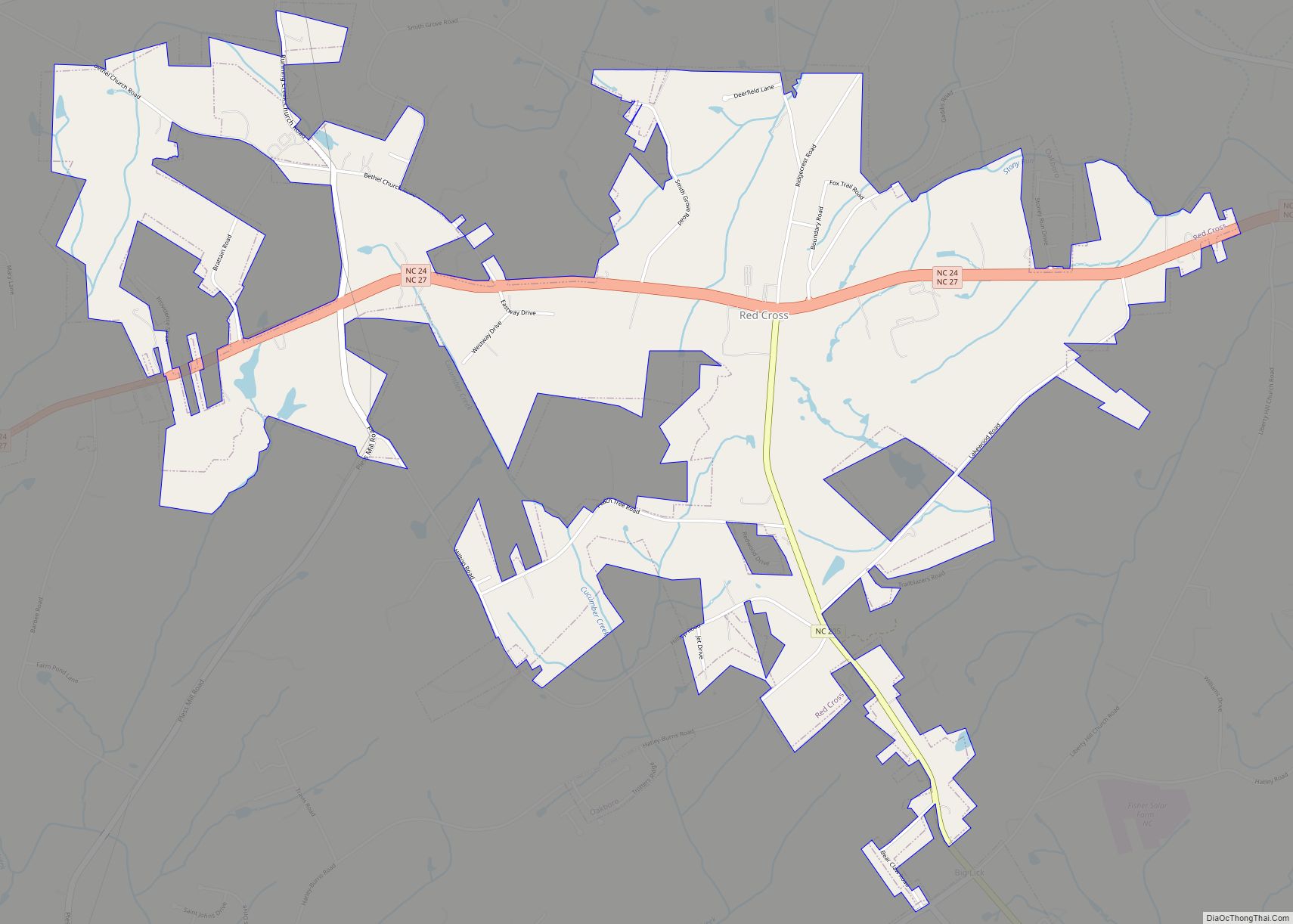
Red Cross is a town in Stanly County, North Carolina, United States. The population was 742 as of the 2010 Census. Red Cross town overview: Name: Red Cross town LSAD Code: 43 LSAD Description: town (suffix) State: North Carolina County: Stanly County Elevation: 659 ft (201 m) Total Area: 3.73 sq mi (9.67 km²) Land Area: 3.73 sq mi (9.67 km²) Water Area: … Read more

Map of Raynham town

Map of Raynham town

Raynham is a town in Robeson County, North Carolina, United States. The population was 72 at the 2010 census. Raynham town overview: Name: Raynham town LSAD Code: 43 LSAD Description: town (suffix) State: North Carolina County: Robeson County Elevation: 144 ft (44 m) Total Area: 0.12 sq mi (0.32 km²) Land Area: 0.12 sq mi (0.32 km²) Water Area: 0.00 sq mi (0.00 km²) Total Population: … Read more

Map of Ranlo town

Map of Ranlo town

Ranlo is a small town in Gaston County, North Carolina, United States and a suburb of Charlotte, located north of Gastonia. As of the 2020 census, the town population was 4,511, up from 3,434 in 2010. Ranlo town overview: Name: Ranlo town LSAD Code: 43 LSAD Description: town (suffix) State: North Carolina County: Gaston County … Read more

Map of Randleman city

Map of Randleman city

Randleman is a city in Randolph County, North Carolina, United States. The population was 4,113 at the 2010 census. It is the home of NASCAR’s Petty family, the Victory Junction Gang Camp and was the location of the Richard Petty Museum from 2003 to 2014. Randleman city overview: Name: Randleman city LSAD Code: 25 LSAD … Read more

Map of Rich Square town

Map of Rich Square town

Rich Square is a town in Northampton County, North Carolina, United States. The population was 958 at the 2010 census. It is part of the Roanoke Rapids, North Carolina Micropolitan Statistical Area. Rich Square town overview: Name: Rich Square town LSAD Code: 43 LSAD Description: town (suffix) State: North Carolina County: Northampton County Elevation: 72 ft … Read more

Map of Robersonville town

Map of Robersonville town

Robersonville, incorporated in 1872, is a town located in Martin County, North Carolina, United States. The population was 1,326 at the 2020 census. Robersonville is located in North Carolina’s Inner Banks region. It is home to the East Carolina Motor Speedway. Robersonville town overview: Name: Robersonville town LSAD Code: 43 LSAD Description: town (suffix) State: … Read more