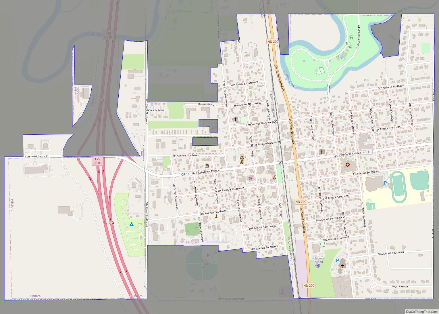
Map of Hurdsfield city
Hurdsfield is a city in Wells County, North Dakota, United States. The population was 64 at the 2020 census. Hurdsfield was founded in 1903. Hurdsfield city overview: Name: Hurdsfield city LSAD Code: 25 LSAD Description: city (suffix) State: North Dakota County: Wells County Founded: 1903 Elevation: 1,913 ft (583 m) Total Area: 0.29 sq mi (0.75 km²) Land Area: 0.29 sq mi ... Read more
Map of Hurdsfield city
Map of Hunter city, North Dakota
Hunter is a city in Cass County, North Dakota, United States. The population was 332 at the 2020 census. Hunter was founded in 1881. Hunter city overview: Name: Hunter city LSAD Code: 25 LSAD Description: city (suffix) State: North Dakota County: Cass County Founded: 1881 Elevation: 978 ft (298 m) Total Area: 1.51 sq mi (3.90 km²) Land Area: 1.49 sq mi ... Read more
Map of Hunter city, North Dakota
Map of Horace city, North Dakota
Horace is a city in Cass County, North Dakota, United States. As of the 2020 census, the population was 3,085. The city is a suburb of the Fargo-Moorhead metropolitan area. It is the sixteenth-largest city in North Dakota. Horace was founded in 1882 at a time of widespread European-American settlement in the territory. Horace city ... Read more
Map of Horace city, North Dakota
Map of Hope city, North Dakota
Hope is a city in Steele County, North Dakota, United States. The population was 272 at the 2020 census. Hope was founded in 1881. Hope city overview: Name: Hope city LSAD Code: 25 LSAD Description: city (suffix) State: North Dakota County: Steele County Founded: 1881 Elevation: 1,240 ft (378 m) Total Area: 0.61 sq mi (1.59 km²) Land Area: 0.61 sq mi ... Read more
Map of Hope city, North Dakota
Map of Knox city, North Dakota
Knox is a city in Benson County, North Dakota, United States. The population was 22 at the 2020 census. Knox was founded in 1887. Knox city overview: Name: Knox city LSAD Code: 25 LSAD Description: city (suffix) State: North Dakota County: Benson County Founded: 1887 Elevation: 1,601 ft (488 m) Total Area: 0.48 sq mi (1.25 km²) Land Area: 0.48 sq mi ... Read more
Map of Knox city, North Dakota
Map of Kindred city
Kindred is a city in Cass County, North Dakota, United States. The population was 889 at the time of the 2020 census. Kindred primarily serves as a bedroom community for Fargo, located about 25 miles to the southwest. Kindred city overview: Name: Kindred city LSAD Code: 25 LSAD Description: city (suffix) State: North Dakota County: ... Read more
Map of Kindred city
Map of Killdeer city
Killdeer (Hidatsa: Cíìdadagi Arudíheesh, “happy land”) is a city in Dunn County, North Dakota, United States. The population was 939 at the 2020 census. Killdeer city overview: Name: Killdeer city LSAD Code: 25 LSAD Description: city (suffix) State: North Dakota County: Dunn County Elevation: 2,290 ft (698 m) Total Area: 1.85 sq mi (4.80 km²) Land Area: 1.85 sq mi (4.79 km²) Water ... Read more
Map of Killdeer city
Map of Kief city
Kief is a city in McHenry County, North Dakota, United States. The population was 8 at the 2020 census. It is part of the Minot Micropolitan Statistical Area. Kief was founded in 1908. Kief city overview: Name: Kief city LSAD Code: 25 LSAD Description: city (suffix) State: North Dakota County: McHenry County Founded: 1908 Elevation: ... Read more
Map of Kief city
Map of Kensal city
Kensal is a city in Stutsman County, North Dakota, United States. The population was 146 at the 2020 census. Kensal was founded in 1892. It is the location of, or nearest community to, the Cecil Baker Round Barn, which was built in 1921 and is listed on the National Register of Historic Places. Kensal city ... Read more
Map of Kensal city
Map of Kenmare city
Kenmare is a city in Ward County, North Dakota, United States. The population was 961 at the 2020 census. Kenmare is part of the Minot Micropolitan Statistical Area. Kenmare city overview: Name: Kenmare city LSAD Code: 25 LSAD Description: city (suffix) State: North Dakota County: Ward County Founded: 1897 Elevation: 1,890 ft (576 m) Total Area: 1.34 sq mi ... Read more
Map of Kenmare city
Map of Kathryn city
Kathryn is a city in Barnes County, North Dakota, United States. The population was 66 at the 2020 census. Kathryn was founded in 1900. It was named after the daughter of a railroad man. Kathryn city overview: Name: Kathryn city LSAD Code: 25 LSAD Description: city (suffix) State: North Dakota County: Barnes County Founded: 1900 ... Read more
Map of Kathryn city
Map of Karlsruhe city
Karlsruhe (/ˈkɑːrlsruː/ KARLSS-roo) is a city in McHenry County, North Dakota, United States. The population was 87 at the 2020 census. Karlsruhe was founded in 1912. Old Saints Peter and Paul Cemetery, Wrought-Iron Cross Site, in or near Karlsruhe, is listed on the National Register of Historic Places. Sts. Peter and Paul Catholic Church in ... Read more
Map of Karlsruhe city