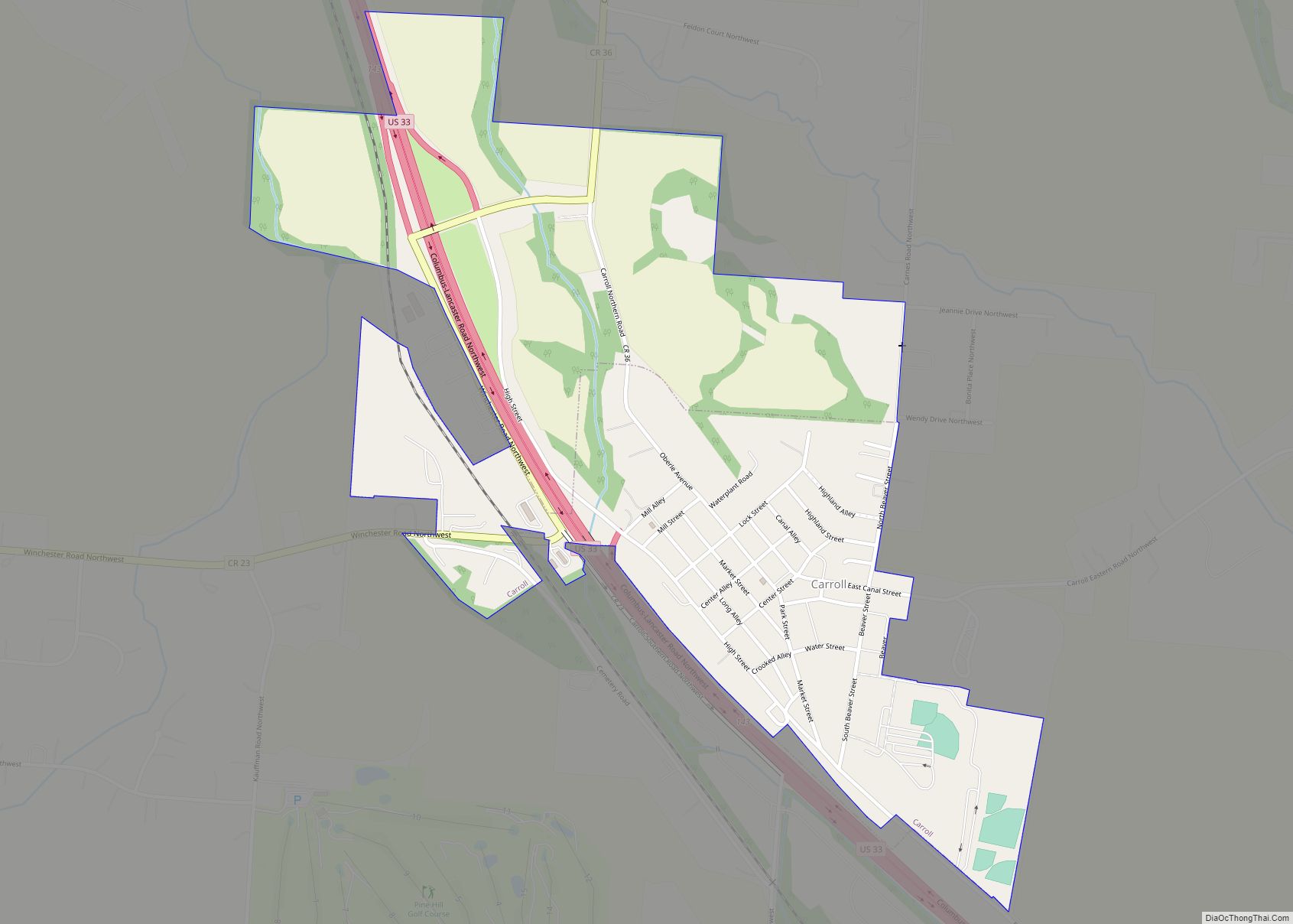
Carroll is a village in Fairfield County, Ohio, United States. The population was 524 at the 2010 census. Carroll village overview: Name: Carroll village LSAD Code: 47 LSAD Description: village (suffix) State: Ohio County: Fairfield County Elevation: 837 ft (255 m) Total Area: 0.63 sq mi (1.63 km²) Land Area: 0.63 sq mi (1.63 km²) Water Area: 0.00 sq mi (0.00 km²) Total Population: 501 Population ... Read more
Ohio Cities and Places
Carlisle (/ˈkɑːrlaɪl/ KAR-lyle) is a city in northwestern Warren and southern Montgomery counties in the southwestern part of the U.S. state of Ohio. The city is in Franklin Township, Warren County, Ohio and German Township, Montgomery County, Ohio. The Warren County portion of Carlisle is part of the Cincinnati–Middletown, OH-KY–IN Metropolitan Statistical Area, while the ... Read more
Carey is a village in Wyandot County, Ohio, United States. The population was 3,507 at the 2019 census. Carey village overview: Name: Carey village LSAD Code: 47 LSAD Description: village (suffix) State: Ohio County: Wyandot County Elevation: 820 ft (250 m) Total Area: 2.17 sq mi (5.61 km²) Land Area: 2.16 sq mi (5.59 km²) Water Area: 0.01 sq mi (0.02 km²) Total Population: 3,565 Population ... Read more
Cardington is a village in Morrow County, Ohio, United States. The population was 2,047 at the 2010 census. Mount Gilead, Ohio, the county seat, is located northeast of Cardington on U.S. Route 42. Cardington village overview: Name: Cardington village LSAD Code: 47 LSAD Description: village (suffix) State: Ohio County: Morrow County Elevation: 1,010 ft (308 m) Total ... Read more
Carbon Hill is an unincorporated community and census-designated place (CDP) in central Ward Township, Hocking County, Ohio, United States. It has a post office with the ZIP code 43111. As of the 2010 census the population of the CDP was 233. State Route 278, located on the western edge of Carbon Hill, is its main ... Read more
Centerville, also known as Thurman, is a village in Gallia County, Ohio, United States. The population was 87 at the 2020 census. It is part of the rural Point Pleasant micropolitan area. It is located near U.S. Route 35 near the eastern terminus of State Route 279 as the highways parallel each other for about ... Read more
Centerburg is a village in Knox County, Ohio, United States, along the North Fork of the Licking River. As of the 2010 census, the village population was 1,773. Centerburg is the geographical center of Ohio. Centerburg village overview: Name: Centerburg village LSAD Code: 47 LSAD Description: village (suffix) State: Ohio County: Knox County Elevation: 1,220 ft ... Read more
Celina (/səˈlaɪnə/ sə-LY-nə) is a city in and the county seat of Mercer County, Ohio, United States about 58 miles northwest of Dayton. The population was 10,400 at the 2010 census. Celina is situated on the northwestern shores of Grand Lake St. Marys. Celina city overview: Name: Celina city LSAD Code: 25 LSAD Description: city ... Read more
Celeryville is an unincorporated community and census-designated place (CDP) on the boundary between New Haven and Richmond townships in Huron County, Ohio, United States. Celeryville is located approximately 1 mile (1.6 km) south of Willard, and the community relies on Willard’s social services. As of the 2010 census the population of the community was 210. Celeryville ... Read more
Cedarville is a village in Greene County, Ohio, United States. The village is within the Dayton Metropolitan Statistical Area. The population was 4,019 at the 2010 census. Cedarville village overview: Name: Cedarville village LSAD Code: 47 LSAD Description: village (suffix) State: Ohio County: Greene County Elevation: 1,050 ft (320 m) Total Area: 1.35 sq mi (3.51 km²) Land Area: 1.31 sq mi ... Read more
Cecil /ˈsiːsəl/ is a village in Paulding County, Ohio, United States. The population was 188 at the 2010 census. Cecil village overview: Name: Cecil village LSAD Code: 47 LSAD Description: village (suffix) State: Ohio County: Paulding County Elevation: 722 ft (220 m) Total Area: 1.46 sq mi (3.79 km²) Land Area: 1.46 sq mi (3.78 km²) Water Area: 0.00 sq mi (0.00 km²) Total Population: 146 ... Read more
Catawba /kəˈtɑːbə/ is a village in Clark County, Ohio, United States. The population was 272 at the 2010 census. It is part of the Springfield, Ohio Metropolitan Statistical Area. Catawba village overview: Name: Catawba village LSAD Code: 47 LSAD Description: village (suffix) State: Ohio County: Clark County Elevation: 1,237 ft (377 m) Total Area: 0.23 sq mi (0.60 km²) Land ... Read more